

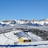
French Ski Areas Announce 2025 Summer Ski Plans
Three French ski areas have announced their opening plans in May, June and July after the winter season ends on May 4th.
Please sign in with your Snow-Forecast account details below.


Saint Gervais Weather (Next 3 days): The snow forecast for Saint Gervais is: Moderate rain (total 16.0mm), heaviest on Sun night. Very mild (max 10°C on Sat afternoon, min 4°C on Sun morning). Wind will be generally light.
Saint Gervais Weather (Days 4-6): Light rain (total 9.0mm) at first, then becoming colder with a dusting of snow on Wed night. Mild temperatures (max 7°C on Tue afternoon, min 1°C on Wed night). Wind will be generally light.
| Resort | Snow Depth | Temp. (°C) | Wind (km/h) | Weather | ||
|---|---|---|---|---|---|---|
| Top Lift: | 4 | |||||
| Middle Lift: | 7 | |||||
| Bottom Lift: | 9 |
Latest snow reports near Saint Gervais:

Sat 12 | Sunday 13 | Monday 14 | Tuesday 15 | Wednesday 16 | Thursday 17 | Friday 18 | ||||||||||||||
PM | night | AM | PM | night | AM | PM | night | AM | PM | night | AM | PM | night | AM | PM | night | AM | PM | night | |
rain shwrs | light rain | cloudy | light rain | light rain | cloudy | light rain | light rain | cloudy | light rain | light rain | light rain | light rain | light snow | light snow | cloudy | some clouds | clear | light rain | rain shwrs | |
km/h | ||||||||||||||||||||
Snow map |  |  |  |  |  |  |  | |||||||||||||
— | — | — | — | — | — | — | — | — | — | — | — | — | 3 | — | — | — | — | — | — | |
2.0 | 4 | — | 3 | 4 | — | 1.0 | 2.0 | — | 1.0 | 1.0 | 2.0 | 5 | — | — | — | — | — | 4 | 3 | |
max°C | 10 | 7 | 6 | 6 | 5 | 5 | 7 | 5 | 6 | 7 | 6 | 3 | 3 | 1 | 2 | 5 | 5 | 7 | 8 | 6 |
min°C | 9 | 5 | 4 | 5 | 4 | 4 | 7 | 4 | 4 | 7 | 4 | 3 | 2 | 1 | 1 | 4 | 4 | 4 | 8 | 4 |
8 | 3 | 3 | 5 | 4 | 3 | 6 | 2 | 2 | 6 | 2 | 2 | 2 | 0 | 1 | 4 | 4 | 3 | 8 | 3 | |
67 | 88 | 79 | 98 | 90 | 81 | 74 | 84 | 72 | 75 | 75 | 93 | 99 | 99 | 93 | 86 | 85 | 72 | 76 | 83 | |
3000 | 2700 | 2700 | 2750 | 2600 | 2650 | 2750 | 2650 | 2750 | 2800 | 2600 | 2400 | 2250 | 2100 | 2300 | 2700 | 2700 | 3000 | 2900 | 2600 | |
— | — | 6:50 | — | — | 6:50 | — | — | 6:48 | — | — | 6:46 | — | — | 6:43 | — | — | 6:41 | — | — | |
— | 8:15 | — | — | 8:15 | — | — | 8:16 | — | — | 8:19 | — | — | 8:20 | — | — | 8:21 | — | — | 8:22 | |
Moderate rain (total 16.0mm), heaviest on Sun night. Very mild (max 10°C on Sat afternoon, min 4°C on Sun morning). Wind will be generally light.
Light rain (total 9.0mm) at first, then becoming colder with a dusting of snow on Wed night. Mild temperatures (max 7°C on Tue afternoon, min 1°C on Wed night). Wind will be generally light.
Latest snow reports near Saint Gervais:
| Top snow depth: | — |
|---|---|
| Bottom snow depth: | — |
| Fresh snowfall depth: | — |
| Last snowfall: | 1 Apr 2025 |
| Snow Alerts | Create Alert |
0.4 | Bluebird Powder days Fresh snow, mostly sunny, light wind. |
|---|---|
0.8 | Powder days Fresh snow, limited sun, any wind. |
0.1 | Bluebird days Average snow, mostly sunny, light wind. |


The above table gives the weather forecast for Saint Gervais at the specific elevation of 1875 m. Our sophisticated weather models allow us to provide snow forecasts for the top, middle and bottom ski stations of Saint Gervais. To access the weather forecasts for the other elevations, use the tab navigation above the table. For a wider view of the weather, check out the Weather Map of France.
Click here to read further information on freezing levels and how we forecast our temperatures.
Overall 4.3 Based on 39 votes and 21 reviews
The whole Evasion Mont Blanc area remains exceptional with great tree-line skiing for all abilities and some challenging off-piste in the snow bowls off Mont Joly and Cote 2000. A good range of mountain restaurants from chic and pricey to home cooked value. Much recommended and following earlier comments, the picturesque but mighty slow Chattrix lift in the St Nicholas area will be replaced by a 6 seat TSK for 2020.
Andrew from United Kingdom writes:
The whole Evasion Mont Blanc area remains exceptional with great tree-line skiing for all abilities and some challenging off-piste in the snow bowls off Mont Joly and Cote 2000. A good range of mountain restaurants from chic and pricey to home cooked value. Much recommended and following earlier comments, the picturesque but mighty slow Chattrix lift in the St Nicholas area will be replaced by a 6 seat TSK for 2020.
The Saint Gervais skiing weather widget is available to embed on external websites free of charge. It provides a daily summary of our Saint Gervais snow forecast and current weather conditions. Simply go to the feed configuration page and follow the 3 simple steps to grab the custom html code snippet and paste it into your own site. You can choose the snow forecast elevation (summit, mid-mountain or bottom lift) and metric/imperial units for the snow forecast feed to suit your own website…. Click here to get the code.
View detailed snow forecast for Saint Gervais at:
snow-forecast.com


 Nearest