

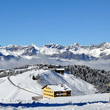
French Ski Areas Announce 2025 Summer Ski Plans
Three French ski areas have announced their opening plans in May, June and July after the winter season ends on May 4th.
Please sign in with your Snow-Forecast account details below.


Saint Gervais Weather (Next 3 days): The snow forecast for Saint Gervais is: Moderate rain (total 17.0mm), heaviest on Sun afternoon. Very mild (max 11°C on Tue afternoon, min 5°C on Mon night). Wind will be generally light.
Saint Gervais Weather (Days 4-6): Heavy rain (total 23.0mm), heaviest during Wed afternoon. Freeze-thaw conditions (max 12°C on Fri afternoon, min 0°C on Wed night). Wind will be generally light.
| Resort | Snow Depth | Temp. (°C) | Wind (km/h) | Weather | ||
|---|---|---|---|---|---|---|
| Top Lift: | 4 | |||||
| Middle Lift: | 7 | |||||
| Bottom Lift: | 9 |
Latest snow reports near Saint Gervais:

Sunday 13 | Monday 14 | Tuesday 15 | Wednesday 16 | Thursday 17 | Friday 18 | ||||||||||||||
night | AM | PM | night | AM | PM | night | AM | PM | night | AM | PM | night | AM | PM | night | AM | PM | night | |
light rain | light rain | mod. rain | light rain | cloudy | light rain | cloudy | cloudy | rain shwrs | rain shwrs | light rain | mod. rain | mod. rain | some clouds | light rain | some clouds | light rain | light rain | rain shwrs | |
km/h | |||||||||||||||||||
Snow map |  |  |  |  |  |  |  | ||||||||||||
— | — | — | — | — | — | — | — | — | — | — | — | — | — | — | — | — | — | — | |
5 | 1.0 | 6 | 2.0 | — | 1.0 | — | — | 2.0 | 1.0 | 3 | 7 | 6 | — | 1.0 | — | 1.0 | 4 | 3 | |
max°C | 9 | 8 | 8 | 7 | 9 | 10 | 6 | 8 | 11 | 8 | 5 | 3 | 2 | 6 | 9 | 7 | 10 | 12 | 8 |
min°C | 6 | 6 | 6 | 6 | 6 | 9 | 5 | 6 | 10 | 5 | 5 | 2 | 0 | 3 | 8 | 5 | 7 | 10 | 5 |
5 | 5 | 6 | 5 | 5 | 8 | 3 | 4 | 10 | 4 | 5 | 1 | -2 | 2 | 8 | 4 | 6 | 10 | 3 | |
89 | 82 | 97 | 83 | 72 | 74 | 88 | 76 | 66 | 85 | 98 | 100 | 90 | 92 | 86 | 88 | 73 | 78 | 83 | |
2700 | 2650 | 2600 | 2550 | 2750 | 2700 | 2650 | 2550 | 2800 | 2550 | 2300 | 1950 | 2300 | 2900 | 3000 | 3000 | 3000 | 2900 | 2550 | |
— | 6:50 | — | — | 6:50 | — | — | 6:48 | — | — | 6:46 | — | — | 6:43 | — | — | 6:41 | — | — | |
— | — | — | 8:15 | — | — | 8:16 | — | — | 8:19 | — | — | 8:20 | — | — | 8:21 | — | — | 8:22 | |
Moderate rain (total 17.0mm), heaviest on Sun afternoon. Very mild (max 11°C on Tue afternoon, min 5°C on Mon night). Wind will be generally light.
Heavy rain (total 23.0mm), heaviest during Wed afternoon. Freeze-thaw conditions (max 12°C on Fri afternoon, min 0°C on Wed night). Wind will be generally light.
Latest snow reports near Saint Gervais:
| Top snow depth: | — |
|---|---|
| Bottom snow depth: | — |
| Fresh snowfall depth: | — |
| Last snowfall: | 1 Apr 2025 |
| Snow Alerts | Create Alert |
0.1 | Bluebird Powder days Fresh snow, mostly sunny, light wind. |
|---|---|
0.2 | Powder days Fresh snow, limited sun, any wind. |
0.0 | Bluebird days Average snow, mostly sunny, light wind. |


The above table gives the weather forecast for Saint Gervais at the specific elevation of 1400 m. Our sophisticated weather models allow us to provide snow forecasts for the top, middle and bottom ski stations of Saint Gervais. To access the weather forecasts for the other elevations, use the tab navigation above the table. For a wider view of the weather, check out the Weather Map of France.
Click here to read further information on freezing levels and how we forecast our temperatures.
Overall 4.3 Based on 39 votes and 21 reviews
As some other reviewers have said this is an excellent resort for mixed ability groups. We went as a group of 4 adults and 6 kids aged 1-9yrs. The older children picked it up quickly after a few lessons and had plenty of easy green slopes to practice on. They even managed a few reds and blues with their dads before the week was out. For anyone else bringing young kids there are plenty of places to rent the sledges that young children can be pushed around in (am sure they have a name!) and there are 2 toboggan runs which even a young child could do on a bum board. We stayed in St. Gervais le Bain, in a chalet, and there was only one cable car up to the resort which the kids enjoyed anyway and the better skiers were able to go on up to access more challenging runs. This holiday was excellent value and we are heading back next month.
D Todd from United Kingdom writes:
As some other reviewers have said this is an excellent resort for mixed ability groups. We went as a group of 4 adults and 6 kids aged 1-9yrs. The older children picked it up quickly after a few lessons and had plenty of easy green slopes to practice on. They even managed a few reds and blues with their dads before the week was out. For anyone else bringing young kids there are plenty of places to rent the sledges that young children can be pushed around in (am sure they have a name!) and there are 2 toboggan runs which even a young child could do on a bum board.
We stayed in St. Gervais le Bain, in a chalet, and there was only one cable car up to the resort which the kids enjoyed anyway and the better skiers were able to go on up to access more challenging runs. This holiday was excellent value and we are heading back next month.
The Saint Gervais skiing weather widget is available to embed on external websites free of charge. It provides a daily summary of our Saint Gervais snow forecast and current weather conditions. Simply go to the feed configuration page and follow the 3 simple steps to grab the custom html code snippet and paste it into your own site. You can choose the snow forecast elevation (summit, mid-mountain or bottom lift) and metric/imperial units for the snow forecast feed to suit your own website…. Click here to get the code.
View detailed snow forecast for Saint Gervais at:
snow-forecast.com


 Nearest