
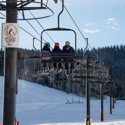
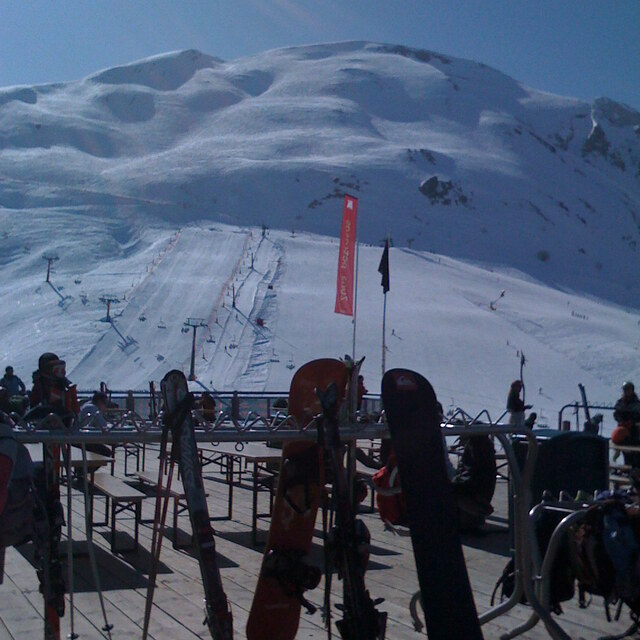
Colorado Resort Replacing 60 Year Old Chairlifts
Colorado’s Sunlight Mountain Resort, has announced the replacement of two of its three chairlifts. The new lifts will replace two double chairlifts that have been operating around six decades.
Please sign in with your Snow-Forecast account details below.

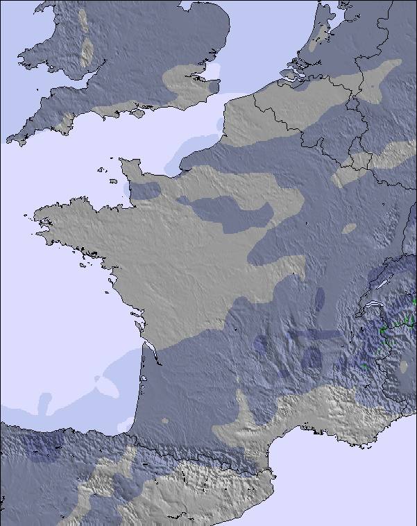
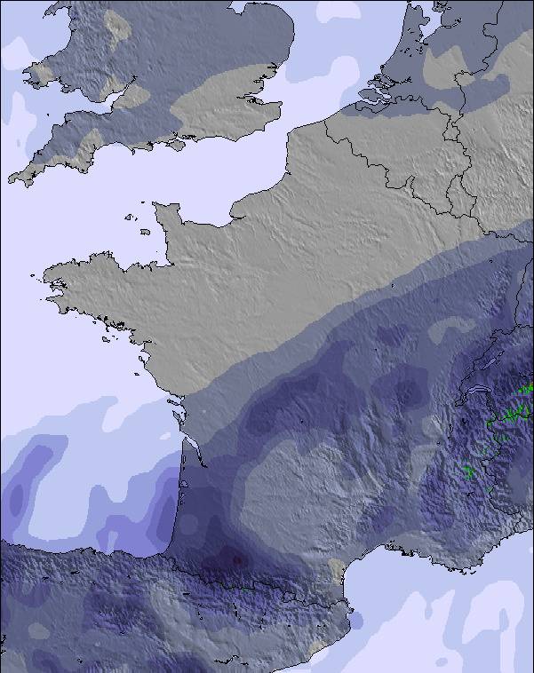
Panticosa Weather (Next 3 days): The snow forecast for Panticosa is: Heavy rain (total 60.0mm), heaviest during Mon morning. Very mild (max 12°C on Sat afternoon, min 5°C on Fri night). Wind will be generally light.
Panticosa Weather (Days 4-6): Heavy rain (total 33.0mm), heaviest during Mon night. Later becoming colder with a dusting of snow on Wed morning. Freeze-thaw conditions (max 10°C on Thu afternoon, min -3°C on Wed night). Wind will be generally light.
| Resort | Snow Depth | Temp. (°C) | Wind (km/h) | Weather | ||
|---|---|---|---|---|---|---|
| Top Lift: | 4 | |||||
| Middle Lift: | 5 | |||||
| Bottom Lift: | 6 |
Latest snow reports near Panticosa:

Saturday 12 | Sunday 13 | Monday 14 | Tuesday 15 | Wednesday 16 | Thursday 17 | ||||||||||||||
night | AM | PM | night | AM | PM | night | AM | PM | night | AM | PM | night | AM | PM | night | AM | PM | night | |
light rain | some clouds | rain shwrs | heavy rain | light rain | light rain | mod. rain | heavy rain | light rain | heavy rain | light rain | mod. rain | light snow | light snow | light rain | snow shwrs | clear | clear | some clouds | |
km/h | |||||||||||||||||||
Snow map |  |  | 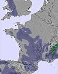 | 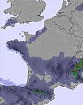 | 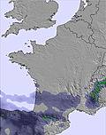 |  |  | ||||||||||||
— | — | — | — | — | — | — | — | — | — | — | — | 2.0 | 2.0 | — | — | — | — | — | |
2.0 | — | 3 | 17 | 2.0 | 5 | 9 | 19 | 3 | 20 | 2.0 | 6 | 3 | — | 2.0 | — | — | — | — | |
max°C | 7 | 8 | 12 | 9 | 8 | 9 | 8 | 5 | 9 | 7 | 4 | 5 | 3 | 1 | 3 | 1 | 6 | 10 | 7 |
min°C | 5 | 6 | 11 | 6 | 7 | 9 | 6 | 5 | 7 | 3 | 3 | 5 | 0 | 0 | 3 | -3 | -2 | 9 | 3 |
3 | 5 | 10 | 5 | 7 | 9 | 6 | 5 | 7 | 2 | 3 | 5 | -4 | -5 | 0 | -7 | -5 | 9 | 3 | |
76 | 80 | 75 | 95 | 89 | 85 | 95 | 94 | 83 | 99 | 91 | 89 | 96 | 84 | 79 | 85 | 35 | 46 | 60 | |
2850 | 2900 | 2900 | 2750 | 2750 | 2850 | 2700 | 2600 | 2750 | 2350 | 2100 | 2200 | 1750 | 1650 | 1950 | 1400 | 2850 | 2950 | 3050 | |
— | 7:24 | — | — | 7:24 | — | — | 7:22 | — | — | 7:20 | — | — | 7:18 | — | — | 7:16 | — | — | |
— | — | — | 8:38 | — | — | 8:39 | — | — | 8:40 | — | — | 8:42 | — | — | 8:43 | — | — | 8:44 | |
Heavy rain (total 60.0mm), heaviest during Mon morning. Very mild (max 12°C on Sat afternoon, min 5°C on Fri night). Wind will be generally light.
Heavy rain (total 33.0mm), heaviest during Mon night. Later becoming colder with a dusting of snow on Wed morning. Freeze-thaw conditions (max 10°C on Thu afternoon, min -3°C on Wed night). Wind will be generally light.
Latest snow reports near Panticosa:
| Top snow depth: | — |
|---|---|
| Bottom snow depth: | — |
| Fresh snowfall depth: | — |
| Last snowfall: | 3 Apr 2025 |
| Snow Alerts | Create Alert |
0.0 | Bluebird Powder days Fresh snow, mostly sunny, light wind. |
|---|---|
0.2 | Powder days Fresh snow, limited sun, any wind. |
0.0 | Bluebird days Average snow, mostly sunny, light wind. |
The above table gives the weather forecast for Panticosa at the specific elevation of 1530 m. Our sophisticated weather models allow us to provide snow forecasts for the top, middle and bottom ski stations of Panticosa. To access the weather forecasts for the other elevations, use the tab navigation above the table. For a wider view of the weather, check out the Weather Map of Spain.
Click here to read further information on freezing levels and how we forecast our temperatures.
Overall 3.8 Based on 34 votes and 5 reviews
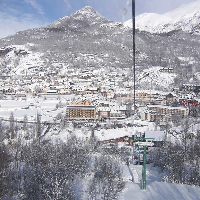
Great little resort full of charm and some good quality skiing.
Michael from United Kingdom writes:
Great little resort full of charm and some good quality skiing.
The Panticosa skiing weather widget is available to embed on external websites free of charge. It provides a daily summary of our Panticosa snow forecast and current weather conditions. Simply go to the feed configuration page and follow the 3 simple steps to grab the custom html code snippet and paste it into your own site. You can choose the snow forecast elevation (summit, mid-mountain or bottom lift) and metric/imperial units for the snow forecast feed to suit your own website…. Click here to get the code.
View detailed snow forecast for Panticosa at:
snow-forecast.com


 Nearest