

US Set To Be Home To World’s New Highest Ski Lift
The US looks set to become the new home of the world’s highest ski lift after Colorado’s Copper Mountain got the go ahead from the White River National Forest to expand its ski area.
Please sign in with your Snow-Forecast account details below.
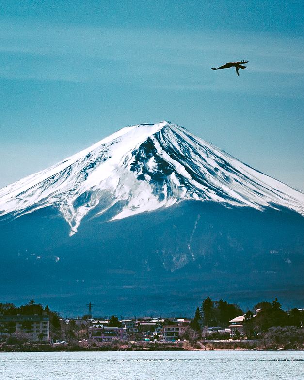

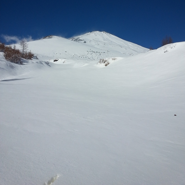
Mount Fuji Weather (Next 3 days): The snow forecast for Mount Fuji is: Light rain (total 9.0mm), mostly falling on Thu night. Mild temperatures (max 8°C on Wed morning, min 2°C on Tue night). Winds increasing (moderate winds from the W on Tue afternoon, severe gales from the W by Tue night).
Mount Fuji Weather (Days 4-6): Light rain (total 5.0mm) at first, then becoming colder with a dusting of snow on Fri night. Freeze-thaw conditions (max 10°C on Fri morning, min -6°C on Sun night). Winds decreasing (fresh winds from the WSW on Fri morning, calm by Sun afternoon).
| Resort | Snow Depth | Temp. (°C) | Wind (km/h) | Weather | ||
|---|---|---|---|---|---|---|
| Top Lift: | -10 | |||||
| Middle Lift: | -5 | |||||
| Bottom Lift: | -1 |
Latest snow reports near Mount Fuji:

Tuesday 25 | Wednesday 26 | Thursday 27 | Friday 28 | Saturday 29 | Sunday 30 | Monday 31 | |||||||||||||||
AM | PM | night | AM | PM | night | AM | PM | night | AM | PM | night | AM | PM | night | AM | PM | night | AM | PM | night | |
clear | clear | clear | clear | clear | clear | clear | some clouds | mod. rain | rain shwrs | rain shwrs | light snow | light snow | light snow | light snow | some clouds | some clouds | snow shwrs | light snow | light snow | light snow | |
km/h | |||||||||||||||||||||
Snow map |  |  |  |  |  |  |  | ||||||||||||||
— | — | — | — | — | — | — | — | — | — | — | 1.0 | — | — | 1.0 | — | — | — | 1.0 | 2.0 | 2.0 | |
— | — | — | — | — | — | — | — | 9 | 1.0 | 1.0 | 3 | — | — | — | — | — | — | — | — | — | |
max°C | 4 | 5 | 2 | 8 | 8 | 5 | 8 | 7 | 6 | 10 | 10 | 6 | 0 | -2 | -4 | -2 | -2 | -4 | -5 | -5 | -4 |
min°C | 3 | 3 | 2 | 6 | 5 | 4 | 7 | 6 | 5 | 8 | 7 | 1 | -1 | -3 | -5 | -3 | -4 | -6 | -6 | -5 | -6 |
-3 | -2 | -4 | 0 | 1 | -1 | 2 | 0 | -1 | 4 | 3 | -5 | -7 | -9 | -13 | -10 | -6 | -13 | -12 | -10 | -11 | |
34 | 46 | 35 | 20 | 23 | 28 | 35 | 65 | 83 | 76 | 73 | 85 | 96 | 67 | 65 | 35 | 50 | 56 | 83 | 99 | 95 | |
2550 | 2700 | 3100 | 3100 | 3150 | 3500 | 3600 | 3550 | 3450 | 3800 | 3600 | 3100 | 2300 | 1850 | 1350 | 1450 | 1750 | 1150 | 1100 | 1250 | 1450 | |
5:41 | — | — | 5:41 | — | — | 5:39 | — | — | 5:37 | — | — | 5:37 | — | — | 5:35 | — | — | 5:33 | — | — | |
— | 6:00 | — | — | 6:00 | — | — | 6:00 | — | — | 6:01 | — | — | 6:02 | — | — | 6:04 | — | — | 6:05 | — | |
Light rain (total 9.0mm), mostly falling on Thu night. Mild temperatures (max 8°C on Wed morning, min 2°C on Tue night). Winds increasing (moderate winds from the W on Tue afternoon, severe gales from the W by Tue night).
Light rain (total 5.0mm) at first, then becoming colder with a dusting of snow on Fri night. Freeze-thaw conditions (max 10°C on Fri morning, min -6°C on Sun night). Winds decreasing (fresh winds from the WSW on Fri morning, calm by Sun afternoon).
Latest snow reports near Mount Fuji:
| Top snow depth: | — |
|---|---|
| Bottom snow depth: | — |
| Fresh snowfall depth: | 1 cm |
| Last snowfall: | 24 Mar 2025 |
| Snow Alerts | Create Alert |
0.6 | Bluebird Powder days Fresh snow, mostly sunny, light wind. |
|---|---|
1.0 | Powder days Fresh snow, limited sun, any wind. |
1.3 | Bluebird days Average snow, mostly sunny, light wind. |
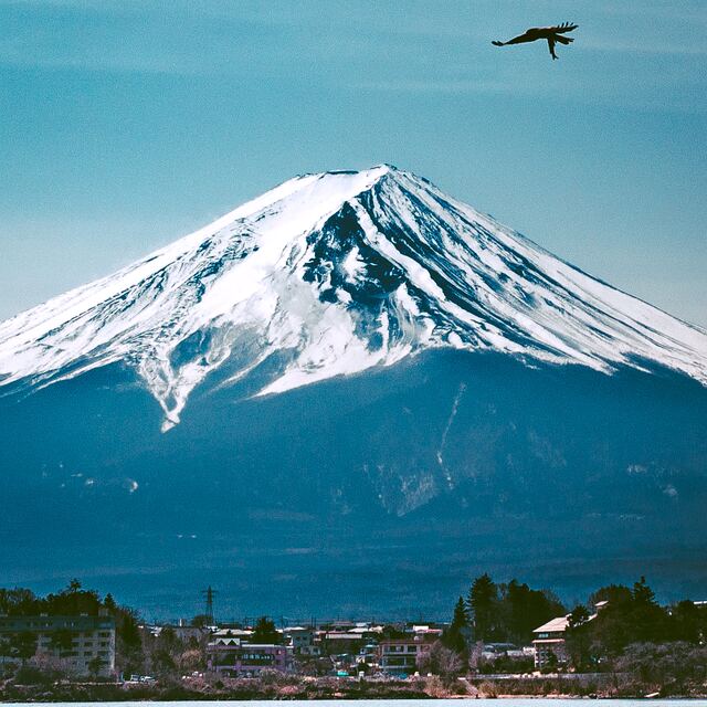
The above table gives the weather forecast for Mount Fuji at the specific elevation of 2252 m. Our sophisticated weather models allow us to provide snow forecasts for the top, middle and bottom ski stations of Mount Fuji. To access the weather forecasts for the other elevations, use the tab navigation above the table. For a wider view of the weather, check out the Weather Map of Japan.
Click here to read further information on freezing levels and how we forecast our temperatures.
Overall 2.8 Based on 2 votes and 7 reviews
My husband and I climbed Mt. Fuji just a few days ago, July 11th in the evening until the morning of July 12 in hopes of seeing the summit sunrise early in the a.m. There is a background history of our/my intentions of making the hike. While my father was stationed near Tokyo in the early 1960s with the United States Air Force, he climbed but his hiking stick with all the brands and stamps was stolen. Therefore, since I am living in Bangkok now with my husband, I wanted to climb Mt. Fuji in a trip to Japan, and earn back his hiking stick over 45+ years later to take back when we return to the United States. I checked the weather conditions, but there was nothing that could have prepared us for this trip up and down the mountain! We took the JR to Otsuki, then a commuter train to Kawaguchiku. When we arrived, it was sprinkling. I began to get nervous and then even more so because we learned from the attendants at the Kawaguchiku station that the last bus to take us to the 5th Gogome had already left just 20 minutes earlier. In a panic, we contracted with a taxi driver to drive us to the 5th station. It cost us 12,500 Yen! That was about $160 USD, but I had come this far and was not going to let my father or us down. So we paid the cash, and as we were driving along, it was dark and gloomy with rain. When we arrived, there was nobody really there, just a few people walking around in and out of the shop. We purchased a cheap set of rain gear and a cover for my husband's backpack, which kept his expensive camera inside. We met a young man from Germany who asked if he could hike with us. The shop closed at 10 and that is when we began our ascent. Again, we have never done this before, but this was completely out of our league, and as we'd learn the next morning upon arrival back at the 5th station, something that ranks among one of the worst conditions on record according to one Japanese guide, who leads groups up and down the mountain as a job, and he's hiked the mountain over 150 times! Thank goodness I got the rain gear. If I was smarter, I'd have put the pants on at the outset, but it wasn't raining so much at the lower elevations. We stopped at the 7th station to get out of the rain that was becoming heavier, along with stronger winds. Even with the intense and severe weather conditions, we were making good time along the Yoshida Trail, the one most popular to climb at night because it is from this side of the summit to the top that one can see the sunrise. That is what we were aiming for. Unfortunately, we would not see a sunrise with the thick fog and cloud cover bringing the rain we endured. We kept going, and stopped briefly to talk to some attendants at one hut at the original 8th station. He said about 40 more minutes and we'd summit. He invited us in, but we decided to keep going and we knew we would turn around right away and descend because it would be before sunrise, and we couldn't see anything anyway. We kept going and then it got so severe, I was so scared for my life. Now, we are not climbers by nature. My husband is a P.E. teacher and I run many marathons, do Muay Thai, play soccer, lift weights, etc. You get the idea. We are in shape, but being physically fit was nowhere near what it took to get through this rough stretch which seemed interminable! I forgot to mention that because it was raining so much and so hard, nobody could brand our walking sticks, which was the ícing on the cake, if you will. It was so terrible we were crouching down holding on to the sides we could grip to avoid being whisked away by the powerful winds and rain. My husband had no protection gear on, and he was actually wearing shorts. Amazingly, however, we weren't cold while climbing, even though it was about 5 degrees Celsius, with over 70 km. winds coming at us. We were so scared for our safety that after we finished, just 300 meters shy of the summit, where we could see two lights, maybe from flashlights where people were seeking shelter somehow (although I was told there is nothing at the summit except the summit itself), we had to turn around and try our best to get to shelter. We have never been so scared for our lives! And everything we read was about how Mt. Fuji is not an intense hike, that there are 70-year old women and people who wear sandals to hike. Maybe it was because we were in the dark, but that just added to the fright, and we could not understand how people would consider this an easy feat by any means. Regardless, we took our time little by little, hiding and shielding ourselves somehow from the sleet and sideways rain pouring over us, soaking us through our clothing and climbing gear, and the strong winds in the night. We made it to some inn, crouched in a bathroom where we saw two men who also decided to turn around. I was feeling so depressed because we hadn't reached our goal. It was barely 4 a.m., so it took us roughly 5.5 hrs. in such conditions, where this trail is estimated to normally take about 5-7 hrs, in favorable weather, probably later in July or in August. Being so early in the climbing season, maybe it is this intense. I was not sure. But we were soon asked to leave by an attendant at this inn unless we each paid 3000 yen for just 3 hours. We literally did not have a choice, and thankfully after our expensive cab trip, we had just enough to cover that expense, and the bus fare back to the train station of 1500 yen apiece. It was enough time for the sun to rise and for my husband to get out of his wickedly soaked clothing, get in to a sleeping bag and take a rest. We were so shaken with the heightened emotional states we were in. I didn't sleep a wink. I just listened to that wind whistle through and rock this little inn, coupled with the noise of other guests who were getting ready to depart, and the rain picking up in strength. Fortunately, when it was time to leave, we had sunlight, but when I saw the light and the mountain, I was even more scared to know what we had actually climbed up without seeing except for maybe 5 feet in front of ourselves with our tiny flashlights. Our clothes were still pretty wet, but we heard it would take about 4-5 hrs. in these conditions to descend. We knew we had better get going to get back on that bus at the 5th station in a reasonable time frame. While the wind was still crazy, along with the rain, descending on the Yoshida Trail was, well, for lack of better words, quite pleasant and much easier than not being able to see where we were to go. We saw many guide posts that had been yanked from their original positions in the mountain, probably due to the winds. The trail at that point going down was pretty flat, but you needed to be cautious that you didn't slip on some of the larger lava rocks on those switchbacks and curves. It was pretty narrow in some parts. We saw many others hiking down who also said they stopped, but I think we were among the only few who made it up so far that night. In fact, we warned time and time again to others who were passing us while we were coming back down, DO NOT GO! TURN AROUND! IT IS TOO DANGEROUS. Now, many spoke English, but how to explain this in Japanese in the darkness with crazy winds and rain halting us from maintaining any sort of upright position or grip? Some just didn't get it and they kept going. It gets better. We descended in about 1.75 hours. We saw many police vehicles at the 5th station and many were huddled inside the shop where we'd purchased our gear. It was there that we learned that all buses were canceled! The conditions were so bad even at the base of the mountain that they were not letting any buses come up to retrieve us hikers and tour guests who'd climbed throughout the night! What were we going to do? We had only enough yen to get us on a bus back to the train station, and there were no ATMs to extract cash, even to pay a taxi once again! (insert sarcastic laugh there). However, we began talking with one Japanese tour guide, who was especially helpful, as he speaks English well, and he explained this to us. He said in all his years and over 150+ hikes up the mountain, he has never witnessed it like this in July. In a way, I felt somewhat relieved and amazed just by how much we achieved the night before. Here we were, rushing to get back down the mountain and a bus would not even be coming for us. Anyway, after about 20 minutes of standing in the shop and changing in to some other clothing, taking off my rain gear, we were informed by this tour guide that they would send a couple buses, but those would be the only buses and the rest would be stranded until the next day when the weather (hopefully) would improve. It was just that dangerous for even vehicles to travel the distance from the base of Mt. Fuji to where we were at the 5th station. Just shortly before 11 a.m., about 2 hours after we got back, a couple of buses arrived to take about 150 of us back to Kawaguchiku Station and the direct bus to Shinjuku. In fact, when we got back to the entrance gates, we were 'greeted' by TV reporters and cameras to get the stories on what had happened. Boy, that would have made an interesting story if I could only speak Japanese. We had spoken with many hikers, young, old, foreign and Japanese who had made the journey, and many had similar stories and fears as us. Like I said earlier, I was depressed because my only wish was to get that walking stick branded at every single station we could, and either mail it or bring it back with me in a year when I return to Wisconsin to visit my parents and family. The picture my father painted about his climb was very different indeed from what my husband and I experienced. I like to think we are adventurous, fearless in some senses, and especially fit. But this 'adventure' played with our emotions and conscience beyond my wildest imagination. Surely, the evening of July 11 to the dawn/early morning of July 12, 2012 will live in our memories forever. With or without branding and stamps on my stick for my father, it will be such a pleasure to give that to him. No pictures to even prove we did it, but I am not a good enough liar to make up a tall tale like this. So now Mt. Fuji is just a memory. And if there was any more icing left to top that cake, it came when I saw a recent Instagram photo posted that showed beautiful Mt. Fuji with green pastures leading up to it in the distance, taken just one day before we hiked. Certainly, their photo doesn't match up to the experience or image I paint in my own head when I think of Mt. Fuji. I just wish maybe it would have been clearer to see that sunrise, but it probably would not have accounted for such a magnificent story, now would it?
Sharin from Thailand writes:
My husband and I climbed Mt. Fuji just a few days ago, July 11th in the evening until the morning of July 12 in hopes of seeing the summit sunrise early in the a.m. There is a background history of our/my intentions of making the hike. While my father was stationed near Tokyo in the early 1960s with the United States Air Force, he climbed but his hiking stick with all the brands and stamps was stolen. Therefore, since I am living in Bangkok now with my husband, I wanted to climb Mt. Fuji in a trip to Japan, and earn back his hiking stick over 45+ years later to take back when we return to the United States.
I checked the weather conditions, but there was nothing that could have prepared us for this trip up and down the mountain! We took the JR to Otsuki, then a commuter train to Kawaguchiku. When we arrived, it was sprinkling. I began to get nervous and then even more so because we learned from the attendants at the Kawaguchiku station that the last bus to take us to the 5th Gogome had already left just 20 minutes earlier. In a panic, we contracted with a taxi driver to drive us to the 5th station. It cost us 12,500 Yen! That was about $160 USD, but I had come this far and was not going to let my father or us down. So we paid the cash, and as we were driving along, it was dark and gloomy with rain.
When we arrived, there was nobody really there, just a few people walking around in and out of the shop. We purchased a cheap set of rain gear and a cover for my husband's backpack, which kept his expensive camera inside. We met a young man from Germany who asked if he could hike with us. The shop closed at 10 and that is when we began our ascent.
Again, we have never done this before, but this was completely out of our league, and as we'd learn the next morning upon arrival back at the 5th station, something that ranks among one of the worst conditions on record according to one Japanese guide, who leads groups up and down the mountain as a job, and he's hiked the mountain over 150 times!
Thank goodness I got the rain gear. If I was smarter, I'd have put the pants on at the outset, but it wasn't raining so much at the lower elevations. We stopped at the 7th station to get out of the rain that was becoming heavier, along with stronger winds.
Even with the intense and severe weather conditions, we were making good time along the Yoshida Trail, the one most popular to climb at night because it is from this side of the summit to the top that one can see the sunrise. That is what we were aiming for. Unfortunately, we would not see a sunrise with the thick fog and cloud cover bringing the rain we endured.
We kept going, and stopped briefly to talk to some attendants at one hut at the original 8th station. He said about 40 more minutes and we'd summit. He invited us in, but we decided to keep going and we knew we would turn around right away and descend because it would be before sunrise, and we couldn't see anything anyway.
We kept going and then it got so severe, I was so scared for my life. Now, we are not climbers by nature. My husband is a P.E. teacher and I run many marathons, do Muay Thai, play soccer, lift weights, etc. You get the idea. We are in shape, but being physically fit was nowhere near what it took to get through this rough stretch which seemed interminable!
I forgot to mention that because it was raining so much and so hard, nobody could brand our walking sticks, which was the ícing on the cake, if you will. It was so terrible we were crouching down holding on to the sides we could grip to avoid being whisked away by the powerful winds and rain. My husband had no protection gear on, and he was actually wearing shorts. Amazingly, however, we weren't cold while climbing, even though it was about 5 degrees Celsius, with over 70 km. winds coming at us. We were so scared for our safety that after we finished, just 300 meters shy of the summit, where we could see two lights, maybe from flashlights where people were seeking shelter somehow (although I was told there is nothing at the summit except the summit itself), we had to turn around and try our best to get to shelter. We have never been so scared for our lives! And everything we read was about how Mt. Fuji is not an intense hike, that there are 70-year old women and people who wear sandals to hike. Maybe it was because we were in the dark, but that just added to the fright, and we could not understand how people would consider this an easy feat by any means.
Regardless, we took our time little by little, hiding and shielding ourselves somehow from the sleet and sideways rain pouring over us, soaking us through our clothing and climbing gear, and the strong winds in the night. We made it to some inn, crouched in a bathroom where we saw two men who also decided to turn around. I was feeling so depressed because we hadn't reached our goal. It was barely 4 a.m., so it took us roughly 5.5 hrs. in such conditions, where this trail is estimated to normally take about 5-7 hrs, in favorable weather, probably later in July or in August. Being so early in the climbing season, maybe it is this intense. I was not sure. But we were soon asked to leave by an attendant at this inn unless we each paid 3000 yen for just 3 hours. We literally did not have a choice, and thankfully after our expensive cab trip, we had just enough to cover that expense, and the bus fare back to the train station of 1500 yen apiece. It was enough time for the sun to rise and for my husband to get out of his wickedly soaked clothing, get in to a sleeping bag and take a rest. We were so shaken with the heightened emotional states we were in. I didn't sleep a wink. I just listened to that wind whistle through and rock this little inn, coupled with the noise of other guests who were getting ready to depart, and the rain picking up in strength.
Fortunately, when it was time to leave, we had sunlight, but when I saw the light and the mountain, I was even more scared to know what we had actually climbed up without seeing except for maybe 5 feet in front of ourselves with our tiny flashlights. Our clothes were still pretty wet, but we heard it would take about 4-5 hrs. in these conditions to descend. We knew we had better get going to get back on that bus at the 5th station in a reasonable time frame. While the wind was still crazy, along with the rain, descending on the Yoshida Trail was, well, for lack of better words, quite pleasant and much easier than not being able to see where we were to go. We saw many guide posts that had been yanked from their original positions in the mountain, probably due to the winds. The trail at that point going down was pretty flat, but you needed to be cautious that you didn't slip on some of the larger lava rocks on those switchbacks and curves. It was pretty narrow in some parts. We saw many others hiking down who also said they stopped, but I think we were among the only few who made it up so far that night. In fact, we warned time and time again to others who were passing us while we were coming back down, DO NOT GO! TURN AROUND! IT IS TOO DANGEROUS. Now, many spoke English, but how to explain this in Japanese in the darkness with crazy winds and rain halting us from maintaining any sort of upright position or grip? Some just didn't get it and they kept going.
It gets better. We descended in about 1.75 hours. We saw many police vehicles at the 5th station and many were huddled inside the shop where we'd purchased our gear. It was there that we learned that all buses were canceled! The conditions were so bad even at the base of the mountain that they were not letting any buses come up to retrieve us hikers and tour guests who'd climbed throughout the night! What were we going to do? We had only enough yen to get us on a bus back to the train station, and there were no ATMs to extract cash, even to pay a taxi once again! (insert sarcastic laugh there). However, we began talking with one Japanese tour guide, who was especially helpful, as he speaks English well, and he explained this to us. He said in all his years and over 150+ hikes up the mountain, he has never witnessed it like this in July. In a way, I felt somewhat relieved and amazed just by how much we achieved the night before. Here we were, rushing to get back down the mountain and a bus would not even be coming for us. Anyway, after about 20 minutes of standing in the shop and changing in to some other clothing, taking off my rain gear, we were informed by this tour guide that they would send a couple buses, but those would be the only buses and the rest would be stranded until the next day when the weather (hopefully) would improve. It was just that dangerous for even vehicles to travel the distance from the base of Mt. Fuji to where we were at the 5th station. Just shortly before 11 a.m., about 2 hours after we got back, a couple of buses arrived to take about 150 of us back to Kawaguchiku Station and the direct bus to Shinjuku. In fact, when we got back to the entrance gates, we were 'greeted' by TV reporters and cameras to get the stories on what had happened. Boy, that would have made an interesting story if I could only speak Japanese. We had spoken with many hikers, young, old, foreign and Japanese who had made the journey, and many had similar stories and fears as us. Like I said earlier, I was depressed because my only wish was to get that walking stick branded at every single station we could, and either mail it or bring it back with me in a year when I return to Wisconsin to visit my parents and family. The picture my father painted about his climb was very different indeed from what my husband and I experienced. I like to think we are adventurous, fearless in some senses, and especially fit. But this 'adventure' played with our emotions and conscience beyond my wildest imagination. Surely, the evening of July 11 to the dawn/early morning of July 12, 2012 will live in our memories forever. With or without branding and stamps on my stick for my father, it will be such a pleasure to give that to him. No pictures to even prove we did it, but I am not a good enough liar to make up a tall tale like this. So now Mt. Fuji is just a memory. And if there was any more icing left to top that cake, it came when I saw a recent Instagram photo posted that showed beautiful Mt. Fuji with green pastures leading up to it in the distance, taken just one day before we hiked. Certainly, their photo doesn't match up to the experience or image I paint in my own head when I think of Mt. Fuji. I just wish maybe it would have been clearer to see that sunrise, but it probably would not have accounted for such a magnificent story, now would it?
The Mount Fuji skiing weather widget is available to embed on external websites free of charge. It provides a daily summary of our Mount Fuji snow forecast and current weather conditions. Simply go to the feed configuration page and follow the 3 simple steps to grab the custom html code snippet and paste it into your own site. You can choose the snow forecast elevation (summit, mid-mountain or bottom lift) and metric/imperial units for the snow forecast feed to suit your own website…. Click here to get the code.
View detailed snow forecast for Mount Fuji at:
snow-forecast.com


 Nearest