

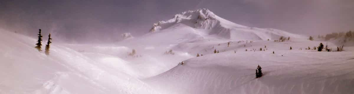
Massive Snowfall in the Alps
A huge snowfall is underway in the Alps, by far the biggest of the 24-25 season.
Please sign in with your Snow-Forecast account details below.


Montchavin Weather (Next 3 days): The snow forecast for Montchavin is: A dusting of new snow. Temperatures will be below freezing (max -3°C on Sat morning, min -8°C on Sun night). Wind will be generally light.
Montchavin Weather (Days 4-6): A dusting of new snow. Temperatures will be below freezing (max -3°C on Wed night, min -6°C on Thu morning). Wind will be generally light.
| Resort | Snow Depth | Temp. (°C) | Wind (km/h) | Weather | ||
|---|---|---|---|---|---|---|
| Top Lift: | -3 | |||||
| Middle Lift: | 1 | |||||
| Bottom Lift: | 3 |
Latest snow reports near Montchavin:
Great conditions for this time of year. Light clouds dotting the sky. from Val Thorens

Saturday 19 | Sunday 20 | Monday 21 | Tuesday 22 | Wednesday 23 | Thursday 24 | Friday 25 | |||||||||||||||
AM | PM | night | AM | PM | night | AM | PM | night | AM | PM | night | AM | PM | night | AM | PM | night | AM | PM | night | |
some clouds | some clouds | snow shwrs | light snow | light snow | snow shwrs | some clouds | some clouds | snow shwrs | clear | snow shwrs | light snow | light snow | cloudy | clear | some clouds | clear | some clouds | clear | clear | some clouds | |
km/h | |||||||||||||||||||||
Snow map |  |  |  |  |  |  |  | ||||||||||||||
— | — | — | 1.0 | 3 | 1.0 | — | — | — | — | — | 1.0 | — | — | — | — | — | — | — | — | — | |
— | — | — | — | — | — | — | — | — | — | — | — | — | — | — | — | — | — | — | — | — | |
max°C | -3 | -4 | -4 | -7 | -6 | -7 | -7 | -6 | -5 | -4 | -4 | -4 | -5 | -5 | -3 | -5 | -6 | -5 | -5 | -5 | -3 |
min°C | -4 | -5 | -6 | -7 | -6 | -8 | -7 | -6 | -6 | -4 | -5 | -5 | -5 | -5 | -5 | -6 | -6 | -5 | -5 | -5 | -5 |
-9 | -11 | -12 | -13 | -12 | -14 | -11 | -9 | -6 | -4 | -5 | -5 | -5 | -5 | -9 | -12 | -12 | -11 | -11 | -10 | -9 | |
66 | 86 | 74 | 94 | 87 | 93 | 76 | 89 | 71 | 46 | 89 | 95 | 89 | 89 | 59 | 56 | 90 | 70 | 73 | 90 | 48 | |
2600 | 2450 | 2200 | 2250 | 2350 | 1700 | 2200 | 2400 | 2300 | 2650 | 2750 | 2500 | 2450 | 2550 | 2550 | 2250 | 2500 | 2250 | 2550 | 2600 | 2650 | |
6:41 | — | — | 6:39 | — | — | 6:37 | — | — | 6:35 | — | — | 6:33 | — | — | 6:33 | — | — | 6:31 | — | — | |
— | — | 8:22 | — | — | 8:24 | — | — | 8:25 | — | — | 8:27 | — | — | 8:28 | — | — | 8:30 | — | — | 8:30 | |
A dusting of new snow. Temperatures will be below freezing (max -3°C on Sat morning, min -8°C on Sun night). Wind will be generally light.
A dusting of new snow. Temperatures will be below freezing (max -3°C on Wed night, min -6°C on Thu morning). Wind will be generally light.
Latest snow reports near Montchavin:
Great conditions for this time of year. Light clouds dotting the sky. from Val Thorens
| Top snow depth: | — |
|---|---|
| Bottom snow depth: | — |
| Fresh snowfall depth: | 89 cm |
| Last snowfall: | 17 Apr 2025 |
| Snow Alerts | Create Alert |
1.0 | Bluebird Powder days Fresh snow, mostly sunny, light wind. |
|---|---|
2.7 | Powder days Fresh snow, limited sun, any wind. |
1.6 | Bluebird days Average snow, mostly sunny, light wind. |
The above table gives the weather forecast for Montchavin at the specific elevation of 3250 m. Our sophisticated weather models allow us to provide snow forecasts for the top, middle and bottom ski stations of Montchavin. To access the weather forecasts for the other elevations, use the tab navigation above the table. For a wider view of the weather, check out the Weather Map of France.
Click here to read further information on freezing levels and how we forecast our temperatures.
Overall 4.5 Based on 8 votes and 8 reviews
We have been to Les Coches on regular ski holidays and found the whole experience fantastic. Skiaffinity offer a great solution to missing the usual gridlock on "transfer Saturday", they offer a Sunday to Sunday package so not only the roads are quieter on a Sunday, we also get to ski on Saturday with only the locals on the slopes. Skiaffinity offer a luxury fully catered chalet within metres of the ski lift and with Laurie and Jess as chalet hosts delivering exceptional fully catered 5 star service. Great village atmosphere, check out "White Lines" après bar also. It was so good at new year we are all heading back next month.
John M from United Kingdom writes:
We have been to Les Coches on regular ski holidays and found the whole experience fantastic. Skiaffinity offer a great solution to missing the usual gridlock on "transfer Saturday", they offer a Sunday to Sunday package so not only the roads are quieter on a Sunday, we also get to ski on Saturday with only the locals on the slopes. Skiaffinity offer a luxury fully catered chalet within metres of the ski lift and with Laurie and Jess as chalet hosts delivering exceptional fully catered 5 star service. Great village atmosphere, check out "White Lines" après bar also. It was so good at new year we are all heading back next month.
The Montchavin skiing weather widget is available to embed on external websites free of charge. It provides a daily summary of our Montchavin snow forecast and current weather conditions. Simply go to the feed configuration page and follow the 3 simple steps to grab the custom html code snippet and paste it into your own site. You can choose the snow forecast elevation (summit, mid-mountain or bottom lift) and metric/imperial units for the snow forecast feed to suit your own website…. Click here to get the code.
View detailed snow forecast for Montchavin at:
snow-forecast.com


 Nearest