

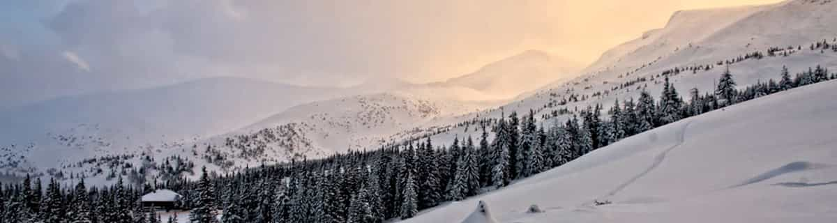
Massive Snowfall in the Alps
A huge snowfall is underway in the Alps, by far the biggest of the 24-25 season.
Please sign in with your Snow-Forecast account details below.


Mont Saint Sauveur Weather (Next 3 days): The snow forecast for Mont Saint Sauveur is: Moderate rain (total 15.0mm), heaviest on Mon night. Freeze-thaw conditions (max 7°C on Mon afternoon, min 0°C on Sun night). Wind will be generally light.
Mont Saint Sauveur Weather (Days 4-6): Heavy rain (total 21.0mm), heaviest during Fri night. Very mild (max 14°C on Fri afternoon, min 3°C on Wed night). Winds increasing (calm on Thu night, fresh winds from the NW by Sat afternoon).
| Resort | Snow Depth | Temp. (°C) | Wind (km/h) | Weather | ||
|---|---|---|---|---|---|---|
| Top Lift: | 0.5 m | 1 | ||||
| Bottom Lift: | 0.1 m | 0 |
Latest snow reports near Mont Saint Sauveur:

Monday 21 | Tuesday 22 | Wednesday 23 | Thursday 24 | Friday 25 | Saturday 26 | ||||||||||||||
night | AM | PM | night | AM | PM | night | AM | PM | night | AM | PM | night | AM | PM | night | AM | PM | night | |
some clouds | some clouds | light rain | heavy rain | light rain | light rain | cloudy | cloudy | cloudy | some clouds | cloudy | cloudy | cloudy | cloudy | cloudy | heavy rain | light rain | light rain | some clouds | |
km/h | |||||||||||||||||||
Snow map |  |  |  |  |  |  |  | ||||||||||||
— | — | — | — | — | — | — | — | — | — | — | — | — | — | — | — | — | — | — | |
— | — | 1.0 | 11 | 2.0 | 1.0 | — | — | — | — | — | — | — | — | — | 17 | 3 | 1.0 | — | |
max°C | 3 | 5 | 7 | 6 | 5 | 4 | 3 | 3 | 5 | 4 | 8 | 11 | 9 | 10 | 14 | 12 | 12 | 6 | 3 |
min°C | 0 | 2 | 5 | 5 | 4 | 4 | 1 | 2 | 5 | 3 | 5 | 11 | 5 | 6 | 13 | 10 | 11 | 5 | -2 |
-2 | 0 | 2 | 2 | -1 | -1 | -3 | -2 | 2 | 1 | 3 | 10 | 3 | 4 | 11 | 7 | 10 | 0 | -8 | |
56 | 38 | 65 | 99 | 88 | 88 | 90 | 78 | 73 | 82 | 65 | 63 | 83 | 59 | 71 | 99 | 97 | 76 | 57 | |
400 | 2700 | 2700 | 2650 | 900 | 950 | 750 | 900 | 1050 | 1150 | 1400 | 1700 | 2450 | 2700 | 2700 | 3050 | 2700 | 1000 | 250 | |
— | 6:01 | — | — | 5:58 | — | — | 5:56 | — | — | 5:54 | — | — | 5:54 | — | — | 5:52 | — | — | |
— | — | 7:50 | — | — | 7:52 | — | — | 7:52 | — | — | 7:53 | — | — | 7:55 | — | — | 7:57 | — | |
Moderate rain (total 15.0mm), heaviest on Mon night. Freeze-thaw conditions (max 7°C on Mon afternoon, min 0°C on Sun night). Wind will be generally light.
Heavy rain (total 21.0mm), heaviest during Fri night. Very mild (max 14°C on Fri afternoon, min 3°C on Wed night). Winds increasing (calm on Thu night, fresh winds from the NW by Sat afternoon).
Latest snow reports near Mont Saint Sauveur:
| Top snow depth: | 50 cm |
|---|---|
| Bottom snow depth: | 10 cm |
| Fresh snowfall depth: | — |
| Last snowfall: | 11 Apr 2025 |
| Snow Alerts | Create Alert |
0.1 | Bluebird Powder days Fresh snow, mostly sunny, light wind. |
|---|---|
0.3 | Powder days Fresh snow, limited sun, any wind. |
0.8 | Bluebird days Average snow, mostly sunny, light wind. |

The above table gives the weather forecast for Mont Saint Sauveur at the specific elevation of 416 m. Our sophisticated weather models allow us to provide snow forecasts for the top, middle and bottom ski stations of Mont Saint Sauveur. To access the weather forecasts for the other elevations, use the tab navigation above the table. For a wider view of the weather, check out the Weather Map of Canada.
Click here to read further information on freezing levels and how we forecast our temperatures.
For a luxurious great outdoors experience try 'Fiddler Lake Resort'. Fabulous log homes set amongst the forest with an easy drive to Morin Heights for skiing or a further 10 minutes on to the beautiful town and ski slopes of St. Sauveur. We really did feel like early settlers with all the mod cons - plus the most amazing snow.
Sue from United Kingdom writes:
For a luxurious great outdoors experience try 'Fiddler Lake Resort'. Fabulous log homes set amongst the forest with an easy drive to Morin Heights for skiing or a further 10 minutes on to the beautiful town and ski slopes of St. Sauveur. We really did feel like early settlers with all the mod cons - plus the most amazing snow.
Read 2 more reviews of Mont Saint Sauveur or submit your own
The Mont Saint Sauveur skiing weather widget is available to embed on external websites free of charge. It provides a daily summary of our Mont Saint Sauveur snow forecast and current weather conditions. Simply go to the feed configuration page and follow the 3 simple steps to grab the custom html code snippet and paste it into your own site. You can choose the snow forecast elevation (summit, mid-mountain or bottom lift) and metric/imperial units for the snow forecast feed to suit your own website…. Click here to get the code.
View detailed snow forecast for Mont Saint Sauveur at:
snow-forecast.com


 Nearest