The snow forecast for Les Gets is: Light rain (total 8.0mm), mostly falling on Tue afternoon. Mild temperatures (max 8°C on Thu afternoon, min 3°C on Tue morning). Wind will be generally light.
Les Gets Weather (Next 3 days): The snow forecast for Les Gets is: Light rain (total 8.0mm), mostly falling on Tue afternoon. Mild temperatures (max 8°C on Thu afternoon, min 3°C on Tue morning). Wind will be generally light.
Les Gets Weather (Days 4-6): Mostly dry. Mild temperatures (max 8°C on Sun afternoon, min 3°C on Fri night). Wind will be generally light.
Les Gets Live Weather
Resort
Snow Depth
Temp. (°F)
Wind (mph)
Weather
Top Lift:
36
Middle Lift:
41
Bottom Lift:
41
Powered by Snow-Forecast.com
Les Gets Weather
(Next 3 days):
The snow forecast for Les Gets is: Light rain (total 0.3in), mostly falling on Tue afternoon. Mild temperatures (max 46°F on Thu afternoon, min 37°F on Tue morning). Wind will be generally light.
Les Gets Weather (Days 4-6):
Mostly dry. Mild temperatures (max 46°F on Sun afternoon, min 37°F on Fri night). Wind will be generally light.
Light rain (total 8.0mm), mostly falling on Tue afternoon. Mild temperatures (max 8°C on Thu afternoon, min 3°C on Tue morning). Wind will be generally light.
Next 4-6 days weather summary:
Mostly dry. Mild temperatures (max 8°C on Sun afternoon, min 3°C on Fri night). Wind will be generally light.
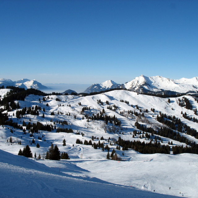
The above table gives the weather forecast for Les Gets at the specific elevation of 2002 m. Our sophisticated weather models allow us to provide snow forecasts for the top, middle and bottom ski stations of Les Gets. To access the weather forecasts for the other elevations, use the tab navigation above the table. For a wider view of the weather, check out the Weather Map of France.
Click here to read further information on freezing levels and how we forecast our temperatures.
Great place for intermediates/beginners. 3 of us went at half term inc my 15 yr old son. We drove down to save on flight costs and self catered, brought 3 meals with us pre-prepared: all wine and beer, snacks etc, so made saving there as well. Took 14 hours but we stopped Friday night south of Dijon to sleep. Managed to get into Les Gets and on piste by 1pm on the Saturday. Stayed at the Perrriere end of the village to avoid crowds at Chavanne (half term); 2 min walk to lift, which was the best decision ever as we could get into the outback and ski fresh pisted runs in the morning before they got chopped up. It was a 15min walk to town but the bus goes every 15 mins and it was fine. Les Gets is a really nice place and we have been here 3 times now, 2 skiing and one summer. We have though outgrown it in terms of the skiing it offers and will be finding a higher resort for next year. But I would throughly recommend it and if you are looking for a ski holiday on a budget then look into driving; the whole week (6.5 days skiing) inc every single expense cost £3600 which at half term is unbelievable, and we still ate out at nice restaurants for 4 nights. We could have skied the Saturday as well but as the snow was not the best by then we decided to come home.
Great place for intermediates/beginners. 3 of us went at half term inc my 15 yr old son. We drove down to save on flight costs and self catered, brought 3 meals with us pre-prepared: all wine and beer, snacks etc, so made saving there as well. Took 14 hours but we stopped Friday night south of Dijon to sleep. Managed to get into Les Gets and on piste by 1pm on the Saturday. Stayed at the Perrriere end of the village to avoid crowds at Chavanne (half term); 2 min walk to lift, which was the best decision ever as we could get into the outback and ski fresh pisted runs in the morning before they got chopped up. It was a 15min walk to town but the bus goes every 15 mins and it was fine. Les Gets is a really nice place and we have been here 3 times now, 2 skiing and one summer. We have though outgrown it in terms of the skiing it offers and will be finding a higher resort for next year. But I would throughly recommend it and if you are looking for a ski holiday on a budget then look into driving; the whole week (6.5 days skiing) inc every single expense cost £3600 which at half term is unbelievable, and we still ate out at nice restaurants for 4 nights. We could have skied the Saturday as well but as the snow was not the best by then we decided to come home.
Free Snow-Forecast.com weather widget for your website
The Les Gets skiing weather widget is available to embed on external websites free of charge. It provides a daily summary of our Les Gets snow forecast and current weather conditions. Simply go to the feed configuration page and follow the 3 simple steps to grab the custom html code snippet and paste it into your own site. You can choose the snow forecast elevation (summit, mid-mountain or bottom lift) and metric/imperial units for the snow forecast feed to suit your own website…. Click here to get the code.


 Nearest