

Tignes Unlimited Festival Into May
Tignes, one of the few French ski areas staying open into May, will round off the 2025–26 winter season with the return of the Tignes Unlimited electronic music festival, running from 25 April to 3 May 2026.

Next 3 days weather summary:Mostly dry. Mild temperatures (max 9°C on Thu afternoon, min 4°C on Tue morning). Wind will be generally light. | Days 4-6 weather summary:Mostly dry. Very mild (max 11°C on Sat afternoon, min 6°C on Fri morning). Wind will be generally light. | |||||||||||||||||
Tuesday 21 | Wednesday 22 | Thursday 23 | Friday 24 | Saturday 25 | Sunday 26 | |||||||||||||
AM | PM | night | AM | PM | night | AM | PM | night | AM | PM | night | AM | PM | night | AM | PM | night | |
clear | clear | clear | clear | clear | clear | clear | clear | clear | clear | clear | clear | clear | clear | some clouds | cloudy | some clouds | clear | |
km/h | ||||||||||||||||||
Snow map |  |  |  |  |  |  | ||||||||||||
— | — | — | — | — | — | — | — | — | — | — | — | — | — | — | — | — | — | |
— | — | — | — | — | — | — | — | — | — | — | — | — | — | — | — | — | — | |
max °C | 5 | 7 | 6 | 6 | 8 | 7 | 7 | 9 | 8 | 8 | 10 | 10 | 8 | 11 | 10 | 8 | 10 | 9 |
min °C | 4 | 6 | 4 | 4 | 7 | 6 | 5 | 8 | 6 | 6 | 9 | 7 | 7 | 10 | 7 | 7 | 9 | 7 |
4 | 4 | 4 | 2 | 6 | 6 | 3 | 6 | 5 | 4 | 7 | 7 | 7 | 10 | 6 | 6 | 7 | 7 | |
66 | 51 | 64 | 57 | 58 | 64 | 63 | 47 | 56 | 43 | 40 | 49 | 47 | 45 | 64 | 67 | 52 | 53 | |
2300 | 2400 | 2250 | 2450 | 2500 | 2350 | 2500 | 2750 | 3100 | 3350 | 3400 | 3450 | 3300 | 3150 | 3200 | 3100 | 2950 | 3150 | |
6:35 | — | — | 6:35 | — | — | 6:33 | — | — | 6:31 | — | — | 6:28 | — | — | 6:28 | — | — | |
— | — | 8:27 | — | — | 8:29 | — | — | 8:30 | — | — | 8:30 | — | — | 8:32 | — | — | 8:34 | |
Latest snow reports near Thollon les Mémises:
| Top snow depth: | 0 cm |
|---|---|
| Bottom snow depth: | 0 cm |
| Fresh snowfall depth: | — |
| Last snowfall: | 13 Apr 2026 |
| Snow Alerts | Create Alert |
0.2 | Bluebird Powder days Fresh snow, mostly sunny, light wind. |
|---|---|
0.3 | Powder days Fresh snow, limited sun, any wind. |
0.2 | Bluebird days Average snow, mostly sunny, light wind. |
The above table gives the weather forecast for Thollon les Mémises at the specific elevation of 1500 m. Our sophisticated weather models allow us to provide snow forecasts for the top, middle and bottom ski stations of Thollon les Mémises. To access the weather forecasts for the other elevations, use the tab navigation above the table. For a wider view of the weather, check out the Weather Map of France.
Click here to read further information on freezing levels and how we forecast our temperatures.
Resort name is also written as Thollon les Memises.
Overall 3.9 Based on 39 votes and 24 reviews
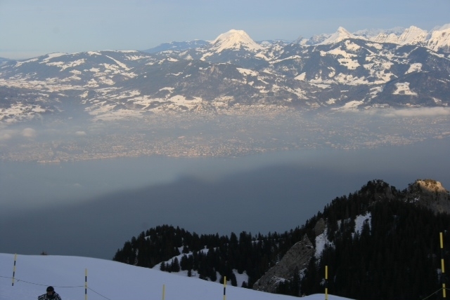
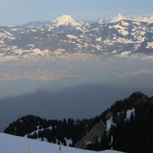
This is the most perfect resort for enjoying the ski season and summer down by the lake-side some 10 minutes drive away. As parents to 3 young children the skiing here is absolutely superb and the most attractive thing, after the stunning views across the Jura mountains and Lake Geneva, is the cost of the lift pass! The big nearby resorts such as Les Gets and and Avoriaz charge €60 per day. Thollon offers fantastic value at €18 per day and concessions for children; just perfect. ESF ski school is superb and the whole ambience of the village is super friendly and authentic. Wonderful snow conditions and we have visited in the summer which is equally magical; either walking in the mountains or swimming down in the lake. Can’t wait to go back.
Mariella Mears from United Kingdom writes:
This is the most perfect resort for enjoying the ski season and summer down by the lake-side some 10 minutes drive away.
As parents to 3 young children the skiing here is absolutely superb and the most attractive thing, after the stunning views across the Jura mountains and Lake Geneva, is the cost of the lift pass! The big nearby resorts such as Les Gets and and Avoriaz charge €60 per day. Thollon offers fantastic value at €18 per day and concessions for children; just perfect. ESF ski school is superb and the whole ambience of the village is super friendly and authentic. Wonderful snow conditions and we have visited in the summer which is equally magical; either walking in the mountains or swimming down in the lake. Can’t wait to go back.
Read 23 more reviews of Thollon les Mémises or submit your own


 Nearest