

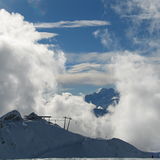
Massive Snowfall in the Alps
A huge snowfall is underway in the Alps, by far the biggest of the 24-25 season.
Please sign in with your Snow-Forecast account details below.


Verbier Weather (Next 3 days): The snow forecast for Verbier is: Moderate rain (total 12.0mm), heaviest on Sun morning. Freeze-thaw conditions (max 7°C on Sat afternoon, min 0°C on Fri night). Wind will be generally light.
Verbier Weather (Days 4-6): Heavy rain (total 45.0mm), heaviest during Thu morning. Mild temperatures (max 9°C on Wed afternoon, min 2°C on Thu morning). Wind will be generally light.
| Resort | Snow Depth | Temp. (°C) | Wind (km/h) | Weather | ||
|---|---|---|---|---|---|---|
| Top Lift: | 1.5 m | -4 | ||||
| Middle Lift: | 1 | |||||
| Bottom Lift: | 0.15 m | 6 |
Latest snow reports near Verbier:
Drizzle reported from Sion at 339 metres elevation only 2 kms NW of Veysonnaz-Printse but it is forecast cold enough for snow at the ski area from Veysonnaz-Printse
Snowing in St-Luc. from St-Luc
Intermittent light rain reported from Sion (6720 -0) at 483 metres elevation only 2 kms N of Veysonnaz-Printse but it is forecast cold enough for snow at the ski area from Veysonnaz-Printse
Snow is falling at La Thuile. from La Thuile
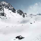
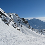
Snow is falling in Verbier. from Verbier

Fri 18 | Saturday 19 | Sunday 20 | Monday 21 | Tuesday 22 | Wednesday 23 | Thursday 24 | ||||||||||||||
PM | night | AM | PM | night | AM | PM | night | AM | PM | night | AM | PM | night | AM | PM | night | AM | PM | night | |
some clouds | some clouds | cloudy | cloudy | rain shwrs | light rain | light rain | light rain | cloudy | light rain | light rain | mod. rain | light rain | light rain | some clouds | light rain | heavy rain | mod. rain | light rain | light snow | |
km/h | ||||||||||||||||||||
Snow map |  |  |  |  |  |  |  | |||||||||||||
— | — | — | — | — | — | — | — | — | — | — | — | — | — | — | — | — | — | — | 2.0 | |
— | — | — | — | 3 | 5 | 2.0 | 2.0 | — | 2.0 | 5 | 7 | 3 | 2.0 | — | 3 | 14 | 9 | 3 | 4 | |
max°C | 6 | 3 | 6 | 7 | 4 | 5 | 7 | 4 | 6 | 7 | 6 | 4 | 5 | 5 | 7 | 9 | 6 | 3 | 4 | 2 |
min°C | 5 | 0 | 2 | 7 | 2 | 3 | 7 | 2 | 3 | 7 | 4 | 4 | 5 | 3 | 4 | 9 | 3 | 2 | 4 | 1 |
5 | -4 | -2 | 4 | -2 | 1 | 4 | 1 | 3 | 7 | 4 | 4 | 5 | 3 | 4 | 9 | 2 | 0 | 2 | -1 | |
77 | 82 | 84 | 80 | 86 | 88 | 73 | 85 | 84 | 87 | 96 | 98 | 97 | 89 | 84 | 80 | 99 | 99 | 99 | 100 | |
2650 | 3050 | 2700 | 2600 | 2350 | 2350 | 2400 | 2150 | 2350 | 2500 | 2300 | 2300 | 2400 | 2350 | 2500 | 2700 | 2300 | 2000 | 2050 | 1800 | |
— | — | 6:37 | — | — | 6:37 | — | — | 6:35 | — | — | 6:33 | — | — | 6:31 | — | — | 6:30 | — | — | |
— | 8:21 | — | — | 8:22 | — | — | 8:23 | — | — | 8:24 | — | — | 8:25 | — | — | 8:27 | — | — | 8:29 | |
Moderate rain (total 12.0mm), heaviest on Sun morning. Freeze-thaw conditions (max 7°C on Sat afternoon, min 0°C on Fri night). Wind will be generally light.
Heavy rain (total 45.0mm), heaviest during Thu morning. Mild temperatures (max 9°C on Wed afternoon, min 2°C on Thu morning). Wind will be generally light.
Latest snow reports near Verbier:
Drizzle reported from Sion at 339 metres elevation only 2 kms NW of Veysonnaz-Printse but it is forecast cold enough for snow at the ski area from Veysonnaz-Printse
Snowing in St-Luc. from St-Luc
Intermittent light rain reported from Sion (6720 -0) at 483 metres elevation only 2 kms N of Veysonnaz-Printse but it is forecast cold enough for snow at the ski area from Veysonnaz-Printse
Snow is falling at La Thuile. from La Thuile
Snow is falling in Verbier. from Verbier
| Top snow depth: | 150 cm |
|---|---|
| Bottom snow depth: | 15 cm |
| Fresh snowfall depth: | 85 cm |
| Last snowfall: | 17 Apr 2025 |
| Snow Alerts | Create Alert |
0.0 | Bluebird Powder days Fresh snow, mostly sunny, light wind. |
|---|---|
0.8 | Powder days Fresh snow, limited sun, any wind. |
0.0 | Bluebird days Average snow, mostly sunny, light wind. |


The above table gives the weather forecast for Verbier at the specific elevation of 1500 m. Our sophisticated weather models allow us to provide snow forecasts for the top, middle and bottom ski stations of Verbier. To access the weather forecasts for the other elevations, use the tab navigation above the table. For a wider view of the weather, check out the Weather Map of Switzerland.
Click here to read further information on freezing levels and how we forecast our temperatures.
Overall 4.1 Based on 93 votes and 97 reviews
It was really great this year, mainly because English were not there, Verbier coming to its root!
Nox from Switzerland writes:
It was really great this year, mainly because English were not there, Verbier coming to its root!
The Verbier skiing weather widget is available to embed on external websites free of charge. It provides a daily summary of our Verbier snow forecast and current weather conditions. Simply go to the feed configuration page and follow the 3 simple steps to grab the custom html code snippet and paste it into your own site. You can choose the snow forecast elevation (summit, mid-mountain or bottom lift) and metric/imperial units for the snow forecast feed to suit your own website…. Click here to get the code.
View detailed snow forecast for Verbier at:
snow-forecast.com


 Nearest