The snow forecast for Stowe is: Heavy rain (total 24.0mm), heaviest during Sat morning. Later becoming colder with a dusting of snow on Sat night. Freeze-thaw conditions (max 14°C on Thu afternoon, min -1°C on Sat night). Winds increasing (calm on Fri afternoon, fresh winds from the SSW by Fri night).
Stowe Weather (Next 3 days): The snow forecast for Stowe is: Heavy rain (total 24.0mm), heaviest during Sat morning. Later becoming colder with a dusting of snow on Sat night. Freeze-thaw conditions (max 14°C on Thu afternoon, min -1°C on Sat night). Winds increasing (calm on Fri afternoon, fresh winds from the SSW by Fri night).
Stowe Weather (Days 4-6): A dusting of snow turning to light rain (total 7.0mm) on Sun afternoon. Freeze-thaw conditions (max 19°C on Tue afternoon, min -1°C on Sun morning). Winds increasing (light winds from the W on Mon afternoon, near gales from the WSW by Tue night).
Stowe Live Weather
Resort
Snow Depth
Temp. (°C)
Wind (km/h)
Weather
Top Lift:
1.2m
5
Middle Lift:
6
Bottom Lift:
0.3m
7
Powered by Snow-Forecast.com
Stowe Weather
(Next 3 days):
The snow forecast for Stowe is: Heavy rain (total 24.0mm), heaviest during Sat morning. Later becoming colder with a dusting of snow on Sat night. Freeze-thaw conditions (max 14°C on Thu afternoon, min -1°C on Sat night). Winds increasing (calm on Fri afternoon, fresh winds from the SSW by Fri night).
Stowe Weather (Days 4-6):
A dusting of snow turning to light rain (total 7.0mm) on Sun afternoon. Freeze-thaw conditions (max 19°C on Tue afternoon, min -1°C on Sun morning). Winds increasing (light winds from the W on Mon afternoon, near gales from the WSW by Tue night).
Heavy rain (total 24.0mm), heaviest during Sat morning. Later becoming colder with a dusting of snow on Sat night. Freeze-thaw conditions (max 14°C on Thu afternoon, min -1°C on Sat night). Winds increasing (calm on Fri afternoon, fresh winds from the SSW by Fri night).
Next 4-6 days weather summary:
A dusting of snow turning to light rain (total 7.0mm) on Sun afternoon. Freeze-thaw conditions (max 19°C on Tue afternoon, min -1°C on Sun morning). Winds increasing (light winds from the W on Mon afternoon, near gales from the WSW by Tue night).
The above table gives the weather forecast for Stowe at the specific elevation of 750 m. Our sophisticated weather models allow us to provide snow forecasts for the top, middle and bottom ski stations of Stowe. To access the weather forecasts for the other elevations, use the tab navigation above the table. For a wider view of the weather, check out the Weather Map of United States.
Click here to read further information on freezing levels and how we forecast our temperatures.
I've skied New England for over 30 years and Stowe is in my "Top 3" category ... and those three are pretty much tied, each having their own charms.
What I love about Stowe:
Consistently the best conditions of any mountain in the area. They've invested heavily in their snowmaking in the past 8-10 years, and it's really paid off. They've got all state-of-the-art equipment covering 80% of their terrain.
Consistent pitch ... top to bottom. There's no traversing. No ski this trail to get to that trail, yadda yadda. You ski this mountain from top to bottom with no long run-outs, etc... to get back to the lift.
"Chill" ski patrol. Unlike other mountains, the ski patrol at Stowe doesn't act like a police force. If you don't get hurt or act like a jerk, you'll hardly see them all day at this mountain. That said, this is the oldest and possibly best-trained ski patrol in the US. They take great pride in their history and professionalism, and when you need them they'll be there in a heartbeat and provide you the best of care.
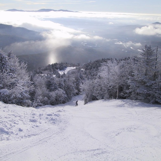
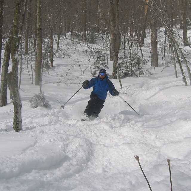
The trails at Stowe are great, especially the Expert terrain. But where Stowe really shines is the vast amount of off-piste skiing available. It is possible to ski from top to bottom without needing to ski a trail (except maybe to cross one) inbounds. Stowe has a boundary to boundary skiing policy, so as long as you enter and exit from open terrain, it's all fair game. If you venture out of bounds, there's about as much easily accessible acreage as there is inbounds. There are a number of factors that make the out of bounds terrain so good. First is that many of the original trails that were cut on Mansfield in the 30's actually didn't end up being incorporated into the modern-day resort. However, those trails still exist, and are skiable ... though for some of them, you'll end up in Underhill State Park, so you'd better have a ride home planned. There is one called "The Bruce" which ends near "The Matterhorn", about two miles down Mountain Road from the resort where you can grab the free shuttle back to the lifts. Heading into the off-piste areas to the North of the gondola provides a huge wooded playground that drops you into the Notch, and you can ski down the closed part of 108 and then it's a short walk back to the gondi. There is much of the out of bounds terrain that is "unofficially" maintained and thinned by the local ski bums during the off-season ... so lots of great secrets to discover.
Finally, since being recently acquired by Vail Resorts, the ticket prices have been moderated some. If you walk up to the window, prepare to be gouged. However, if you buy your ticket online at least 48-hours in advance, you save a considerable sum. Also, Stowe is part of the "Epic Pass", so if you buy a season pass, you gain access to (as of this writing) Stowe, Okemo and Sunapee in the East, plus all of Vail's Western properties. An EpicPass can be had for under $1000 and provides unrestricted access to 65 resorts around the world.
I've skied New England for over 30 years and Stowe is in my "Top 3" category ... and those three are pretty much tied, each having their own charms.
What I love about Stowe:
Consistently the best conditions of any mountain in the area. They've invested heavily in their snowmaking in the past 8-10 years, and it's really paid off. They've got all state-of-the-art equipment covering 80% of their terrain.
Consistent pitch ... top to bottom. There's no traversing. No ski this trail to get to that trail, yadda yadda. You ski this mountain from top to bottom with no long run-outs, etc... to get back to the lift.
"Chill" ski patrol. Unlike other mountains, the ski patrol at Stowe doesn't act like a police force. If you don't get hurt or act like a jerk, you'll hardly see them all day at this mountain. That said, this is the oldest and possibly best-trained ski patrol in the US. They take great pride in their history and professionalism, and when you need them they'll be there in a heartbeat and provide you the best of care.
The trails at Stowe are great, especially the Expert terrain. But where Stowe really shines is the vast amount of off-piste skiing available. It is possible to ski from top to bottom without needing to ski a trail (except maybe to cross one) inbounds. Stowe has a boundary to boundary skiing policy, so as long as you enter and exit from open terrain, it's all fair game. If you venture out of bounds, there's about as much easily accessible acreage as there is inbounds. There are a number of factors that make the out of bounds terrain so good. First is that many of the original trails that were cut on Mansfield in the 30's actually didn't end up being incorporated into the modern-day resort. However, those trails still exist, and are skiable ... though for some of them, you'll end up in Underhill State Park, so you'd better have a ride home planned. There is one called "The Bruce" which ends near "The Matterhorn", about two miles down Mountain Road from the resort where you can grab the free shuttle back to the lifts. Heading into the off-piste areas to the North of the gondola provides a huge wooded playground that drops you into the Notch, and you can ski down the closed part of 108 and then it's a short walk back to the gondi. There is much of the out of bounds terrain that is "unofficially" maintained and thinned by the local ski bums during the off-season ... so lots of great secrets to discover.
Finally, since being recently acquired by Vail Resorts, the ticket prices have been moderated some. If you walk up to the window, prepare to be gouged. However, if you buy your ticket online at least 48-hours in advance, you save a considerable sum. Also, Stowe is part of the "Epic Pass", so if you buy a season pass, you gain access to (as of this writing) Stowe, Okemo and Sunapee in the East, plus all of Vail's Western properties. An EpicPass can be had for under $1000 and provides unrestricted access to 65 resorts around the world.
Free Snow-Forecast.com weather widget for your website
The Stowe skiing weather widget is available to embed on external websites free of charge. It provides a daily summary of our Stowe snow forecast and current weather conditions. Simply go to the feed configuration page and follow the 3 simple steps to grab the custom html code snippet and paste it into your own site. You can choose the snow forecast elevation (summit, mid-mountain or bottom lift) and metric/imperial units for the snow forecast feed to suit your own website…. Click here to get the code.


 Nearest