

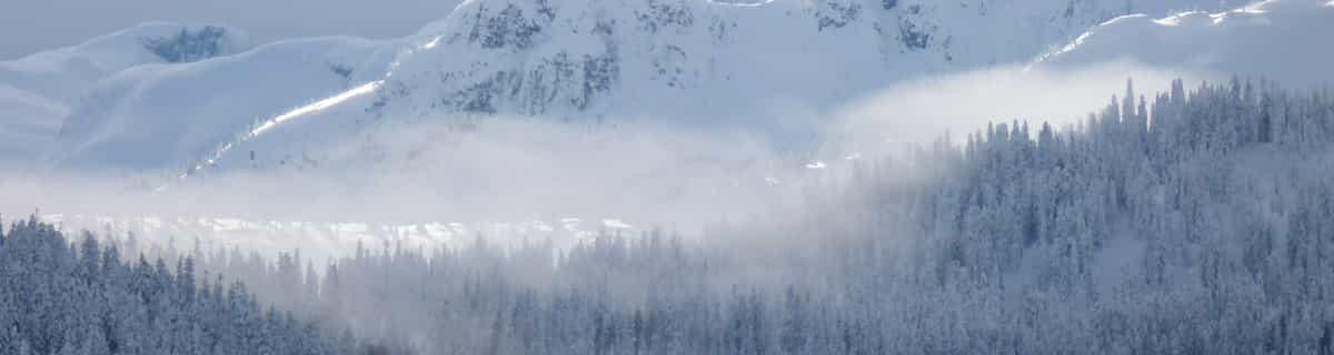
North American Ski Areas Extend Seasons & Slope Opening Hours
Ski areas in Canada and the USA have been announcing extensions to their seasons and, in some cases, longer slope opening hours daily, after big snowfalls in late March and early April.
Please sign in with your Snow-Forecast account details below.

Sterling Forest Ski Center Weather (Next 3 days): The snow forecast for Sterling Forest Ski Center is: Moderate rain (total 13.0mm) heaviest on Sat night, then becoming colder with a dusting of snow on Sun night. Freeze-thaw conditions (max 11°C on Sat night, min -4°C on Mon night). Winds increasing (calm on Sat night, fresh winds from the NW by Tue morning).
Sterling Forest Ski Center Weather (Days 4-6): Light rain (total 2.0mm), mostly falling on Thu morning. Freeze-thaw conditions (max 11°C on Fri morning, min -4°C on Tue night). Mainly fresh winds.
| Resort | Snow Depth | Temp. (°F) | Wind (mph) | Weather | ||
|---|---|---|---|---|---|---|
| Top Lift: | 46 | |||||
| Bottom Lift: | 46 |
Latest snow reports near Sterling Forest Ski Center:

Sat 5 | Sunday 6 | Monday 7 | Tuesday 8 | Wednesday 9 | Thursday 10 | Friday 11 | ||||||||||||||
PM | night | AM | PM | night | AM | PM | night | AM | PM | night | AM | PM | night | AM | PM | night | AM | PM | night | |
light rain | mod. rain | light rain | cloudy | light snow | light snow | light snow | some clouds | some clouds | cloudy | clear | clear | cloudy | snow shwrs | light rain | cloudy | light rain | cloudy | cloudy | cloudy | |
mph | ||||||||||||||||||||
Snow map |  |  |  |  | 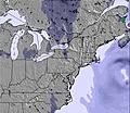 | 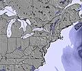 | 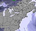 | |||||||||||||
— | — | — | — | 1 | 1 | — | — | — | — | — | — | — | — | — | — | — | — | — | — | |
0.08 | 0.2 | 0.1 | — | 0.08 | — | — | — | — | — | — | — | — | — | 0.04 | — | 0.04 | — | — | — | |
max°F | 46 | 52 | 52 | 50 | 43 | 36 | 37 | 37 | 28 | 34 | 28 | 34 | 45 | 37 | 43 | 50 | 48 | 52 | 52 | 45 |
min°F | 46 | 45 | 48 | 45 | 36 | 34 | 36 | 25 | 25 | 34 | 25 | 27 | 41 | 36 | 39 | 50 | 48 | 50 | 50 | 39 |
41 | 43 | 43 | 39 | 36 | 34 | 36 | 12 | 10 | 23 | 14 | 18 | 36 | 30 | 32 | 45 | 43 | 46 | 48 | 39 | |
89 | 96 | 86 | 53 | 86 | 97 | 92 | 84 | 52 | 49 | 78 | 40 | 35 | 69 | 64 | 71 | 89 | 70 | 77 | 87 | |
11800 | 12300 | 12000 | 10500 | 3800 | 2800 | 3100 | 1600 | 500 | 1500 | — | 1500 | 3400 | 2300 | 4600 | 6700 | 6900 | 6600 | 6700 | 5100 | |
— | — | 6:33 | — | — | 6:31 | — | — | 6:28 | — | — | 6:28 | — | — | 6:26 | — | — | 6:24 | — | — | |
7:25 | — | — | 7:27 | — | — | 7:28 | — | — | 7:29 | — | — | 7:30 | — | — | 7:30 | — | — | 7:31 | — | |
Moderate rain (total 13.0mm) heaviest on Sat night, then becoming colder with a dusting of snow on Sun night. Freeze-thaw conditions (max 11°C on Sat night, min -4°C on Mon night). Winds increasing (calm on Sat night, fresh winds from the NW by Tue morning).
Light rain (total 2.0mm), mostly falling on Thu morning. Freeze-thaw conditions (max 11°C on Fri morning, min -4°C on Tue night). Mainly fresh winds.
Latest snow reports near Sterling Forest Ski Center:
| Top snow depth: | — |
|---|---|
| Bottom snow depth: | — |
| Fresh snowfall depth: | — |
| Last snowfall: | 23 Mar 2025 |
| Snow Alerts | Create Alert |
0.1 | Bluebird Powder days Fresh snow, mostly sunny, light wind. |
|---|---|
0.1 | Powder days Fresh snow, limited sun, any wind. |
0.1 | Bluebird days Average snow, mostly sunny, light wind. |
The above table gives the weather forecast for Sterling Forest Ski Center at the specific elevation of 350 m. Our sophisticated weather models allow us to provide snow forecasts for the top, middle and bottom ski stations of Sterling Forest Ski Center. To access the weather forecasts for the other elevations, use the tab navigation above the table. For a wider view of the weather, check out the Weather Map of United States.
Click here to read further information on freezing levels and how we forecast our temperatures.
The Sterling Forest Ski Center skiing weather widget is available to embed on external websites free of charge. It provides a daily summary of our Sterling Forest Ski Center snow forecast and current weather conditions. Simply go to the feed configuration page and follow the 3 simple steps to grab the custom html code snippet and paste it into your own site. You can choose the snow forecast elevation (summit, mid-mountain or bottom lift) and metric/imperial units for the snow forecast feed to suit your own website…. Click here to get the code.
View detailed snow forecast for Sterling Forest Ski Center at:
snow-forecast.com


 Nearest