

Massive Snowfall in the Alps
A huge snowfall is underway in the Alps, by far the biggest of the 24-25 season.
Please sign in with your Snow-Forecast account details below.

Snowbird Weather (Next 3 days): The snow forecast for Snowbird is: Drizzle on Wed night followed by colder weather and a moderate fall of snow, heaviest on Thu morning. Freeze-thaw conditions (max 4°C on Wed night, min -9°C on Thu night). Winds decreasing (fresh winds from the SW on Wed night, light winds from the NNW by Fri morning).
Snowbird Weather (Days 4-6): A dusting of snow on Sat night. Freezing level rising with drizzle on Sun night. Freeze-thaw conditions (max 5°C on Mon afternoon, min -2°C on Sat night). Winds decreasing (strong winds from the SW on Sun night, light winds from the W by Mon night).
| Resort | Snow Depth | Temp. (°C) | Wind (km/h) | Weather | ||
|---|---|---|---|---|---|---|
| Top Lift: | 2.8 m | -1 | ||||
| Middle Lift: | 3 | |||||
| Bottom Lift: | 0.4 m | 5 |
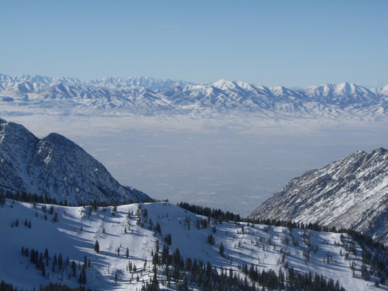
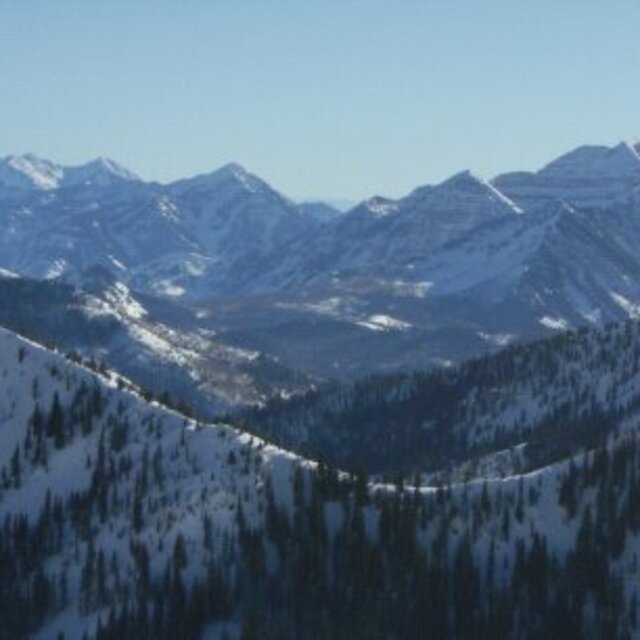
Latest snow reports near Snowbird:

Thursday 17 | Friday 18 | Saturday 19 | Sunday 20 | Monday 21 | Tuesday 22 | ||||||||||||||
night | AM | PM | night | AM | PM | night | AM | PM | night | AM | PM | night | AM | PM | night | AM | PM | night | |
snow shwrs | mod. snow | light snow | light snow | light snow | snow shwrs | clear | clear | clear | snow shwrs | clear | clear | snow shwrs | clear | clear | some clouds | cloudy | cloudy | rain shwrs | |
km/h | |||||||||||||||||||
Snow map |  |  |  |  |  |  |  | ||||||||||||
— | 9 | 2.0 | 2.0 | 4 | — | — | — | — | 1.0 | — | — | — | — | — | — | — | — | — | |
1.0 | — | — | — | — | — | — | — | — | — | — | — | 1.0 | — | — | — | — | — | 2.0 | |
max°C | 4 | -2 | -7 | -7 | -8 | -6 | -6 | -5 | -2 | -1 | 0 | 4 | 3 | 2 | 5 | 4 | 4 | 5 | 3 |
min°C | 1 | -4 | -7 | -9 | -9 | -6 | -7 | -6 | -3 | -2 | -1 | 2 | 1 | 1 | 4 | 3 | 3 | 4 | 2 |
-5 | -10 | -14 | -14 | -13 | -12 | -13 | -10 | -7 | -7 | -6 | -2 | -5 | -4 | -1 | 0 | 0 | 1 | -1 | |
56 | 99 | 89 | 84 | 93 | 76 | 50 | 39 | 46 | 78 | 70 | 51 | 53 | 64 | 39 | 38 | 41 | 51 | 73 | |
3300 | 2600 | 1950 | 1650 | 1600 | 2100 | 1500 | 2000 | 2550 | 2550 | 2700 | 3100 | 3300 | 3000 | 3350 | 3350 | 3300 | 3450 | 3250 | |
— | 6:45 | — | — | 6:43 | — | — | 6:41 | — | — | 6:41 | — | — | 6:39 | — | — | 6:37 | — | — | |
— | — | 8:07 | — | — | 8:07 | — | — | 8:08 | — | — | 8:09 | — | — | 8:10 | — | — | 8:12 | — | |
Drizzle on Wed night followed by colder weather and a moderate fall of snow, heaviest on Thu morning. Freeze-thaw conditions (max 4°C on Wed night, min -9°C on Thu night). Winds decreasing (fresh winds from the SW on Wed night, light winds from the NNW by Fri morning).
A dusting of snow on Sat night. Freezing level rising with drizzle on Sun night. Freeze-thaw conditions (max 5°C on Mon afternoon, min -2°C on Sat night). Winds decreasing (strong winds from the SW on Sun night, light winds from the W by Mon night).
Latest snow reports near Snowbird:
| Top snow depth: | 279 cm |
|---|---|
| Bottom snow depth: | 40 cm |
| Fresh snowfall depth: | — |
| Last snowfall: | 4 Apr 2025 |
| Snow Alerts | Create Alert |
0.6 | Bluebird Powder days Fresh snow, mostly sunny, light wind. |
|---|---|
1.0 | Powder days Fresh snow, limited sun, any wind. |
1.6 | Bluebird days Average snow, mostly sunny, light wind. |


The above table gives the weather forecast for Snowbird at the specific elevation of 2858 m. Our sophisticated weather models allow us to provide snow forecasts for the top, middle and bottom ski stations of Snowbird. To access the weather forecasts for the other elevations, use the tab navigation above the table. For a wider view of the weather, check out the Weather Map of United States.
Click here to read further information on freezing levels and how we forecast our temperatures.
Overall 4.0 Based on 6 votes and 5 reviews
Snowbird is an expert paradise. It has everything you could want, certainly the best snowfal, 500"/yr) in the USA and likely the planet. Endless possibilities of expert terrain from top to bottom. Three huge bowls. Beautiful Scenery. And if you stay just 25 minutes away in the Salt Lake Valley (Sandy/Midvale) the most inexpensive ski vacation you could find. You can board a flight from most major US airports in the morning, including the East Coast, and be skiing by 1pm. And you can do the same on the way home, skiing until noon or later and arriving back home(US) that evening. If you tire of Snowbird, Alta is right next door and then there are 6 other terrific resorts to explore, all within an hour's drive.
SnowbirdDevotee from United States writes:
Snowbird is an expert paradise. It has everything you could want, certainly the best snowfal, 500"/yr) in the USA and likely the planet. Endless possibilities of expert terrain from top to bottom. Three huge bowls. Beautiful Scenery. And if you stay just 25 minutes away in the Salt Lake Valley (Sandy/Midvale) the most inexpensive ski vacation you could find. You can board a flight from most major US airports in the morning, including the East Coast, and be skiing by 1pm. And you can do the same on the way home, skiing until noon or later and arriving back home(US) that evening.
If you tire of Snowbird, Alta is right next door and then there are 6 other terrific resorts to explore, all within an hour's drive.
The Snowbird skiing weather widget is available to embed on external websites free of charge. It provides a daily summary of our Snowbird snow forecast and current weather conditions. Simply go to the feed configuration page and follow the 3 simple steps to grab the custom html code snippet and paste it into your own site. You can choose the snow forecast elevation (summit, mid-mountain or bottom lift) and metric/imperial units for the snow forecast feed to suit your own website…. Click here to get the code.
View detailed snow forecast for Snowbird at:
snow-forecast.com

 Nearest