

Whakapapa's Future Seems Secured As Snow Dumps On New Zealand
New Zealand ski area Whakapapa’s future seems secured as a new operator has been confirmed several years after the previous operators ran into financial problems.
Please sign in with your Snow-Forecast account details below.


Snow Town Yeti Weather (Next 3 days): The snow forecast for Snow Town Yeti is: Light rain (total 2.0mm), mostly falling on Sat night. Very mild (max 14°C on Sun afternoon, min 3°C on Sun night). Winds decreasing (fresh winds from the WSW on Sat night, calm by Mon morning).
Snow Town Yeti Weather (Days 4-6): Heavy rain (total 23.0mm), heaviest during Tue morning. Very mild (max 12°C on Wed afternoon, min 4°C on Tue morning). Wind will be generally light.
| Resort | Snow Depth | Temp. (°F) | Wind (mph) | Weather | ||
|---|---|---|---|---|---|---|
| Top Lift: | 48 | |||||
| Bottom Lift: | 52 |
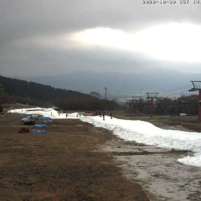
Latest snow reports near Snow Town Yeti:

Saturday 3 | Sunday 4 | Monday 5 | Tuesday 6 | Wednesday 7 | Thursday 8 | Friday 9 | |||||||||||||||
AM | PM | night | AM | PM | night | AM | PM | night | AM | PM | night | AM | PM | night | AM | PM | night | AM | PM | night | |
clear | clear | rain shwrs | rain shwrs | clear | some clouds | clear | some clouds | cloudy | mod. rain | light rain | cloudy | some clouds | some clouds | rain shwrs | light rain | light rain | rain shwrs | some clouds | cloudy | mod. rain | |
mph | |||||||||||||||||||||
Snow map |  |  |  | 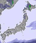 | 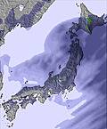 | 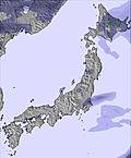 | 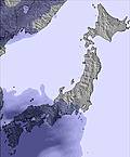 | ||||||||||||||
— | — | — | — | — | — | — | — | — | — | — | — | — | — | — | — | — | — | — | — | — | |
— | — | 0.04 | 0.04 | — | — | — | — | — | 0.2 | 0.2 | — | — | — | 0.1 | 0.08 | 0.2 | 0.2 | — | — | 0.3 | |
max°F | 54 | 52 | 50 | 55 | 57 | 46 | 52 | 50 | 45 | 41 | 45 | 45 | 50 | 54 | 46 | 48 | 46 | 43 | 50 | 48 | 43 |
min°F | 52 | 48 | 46 | 52 | 52 | 37 | 46 | 46 | 45 | 39 | 43 | 45 | 48 | 48 | 45 | 45 | 45 | 41 | 48 | 45 | 39 |
50 | 43 | 39 | 46 | 48 | 32 | 46 | 45 | 41 | 39 | 39 | 39 | 48 | 46 | 45 | 43 | 43 | 41 | 48 | 39 | 32 | |
65 | 77 | 53 | 66 | 29 | 61 | 63 | 59 | 53 | 87 | 92 | 95 | 94 | 85 | 95 | 97 | 93 | 95 | 80 | 87 | 92 | |
12300 | 12000 | 11500 | 10700 | 10300 | 8000 | 9800 | 10700 | 10800 | 10200 | 11200 | 11200 | 10500 | 10800 | 9200 | 8700 | 8500 | 8200 | 11200 | 11600 | 10700 | |
4:52 | — | — | 4:50 | — | — | 4:50 | — | — | 4:48 | — | — | 4:48 | — | — | 4:47 | — | — | 4:46 | — | — | |
— | 6:30 | — | — | 6:31 | — | — | 6:32 | — | — | 6:34 | — | — | 6:35 | — | — | 6:36 | — | — | 6:36 | — | |
Light rain (total 2.0mm), mostly falling on Sat night. Very mild (max 14°C on Sun afternoon, min 3°C on Sun night). Winds decreasing (fresh winds from the WSW on Sat night, calm by Mon morning).
Heavy rain (total 23.0mm), heaviest during Tue morning. Very mild (max 12°C on Wed afternoon, min 4°C on Tue morning). Wind will be generally light.
Latest snow reports near Snow Town Yeti:
| Top snow depth: | — |
|---|---|
| Bottom snow depth: | — |
| Fresh snowfall depth: | — |
| Last snowfall: | 6 Apr 2025 |
| Snow Alerts | Create Alert |
0.0 | Bluebird Powder days Fresh snow, mostly sunny, light wind. |
|---|---|
0.0 | Powder days Fresh snow, limited sun, any wind. |
0.0 | Bluebird days Average snow, mostly sunny, light wind. |

The above table gives the weather forecast for Snow Town Yeti at the specific elevation of 1300 m. Our sophisticated weather models allow us to provide snow forecasts for the top, middle and bottom ski stations of Snow Town Yeti. To access the weather forecasts for the other elevations, use the tab navigation above the table. For a wider view of the weather, check out the Weather Map of Japan.
Click here to read further information on freezing levels and how we forecast our temperatures.
The Snow Town Yeti skiing weather widget is available to embed on external websites free of charge. It provides a daily summary of our Snow Town Yeti snow forecast and current weather conditions. Simply go to the feed configuration page and follow the 3 simple steps to grab the custom html code snippet and paste it into your own site. You can choose the snow forecast elevation (summit, mid-mountain or bottom lift) and metric/imperial units for the snow forecast feed to suit your own website…. Click here to get the code.
View detailed snow forecast for Snow Town Yeti at:
snow-forecast.com


 Nearest