

Massive Snowfall in the Alps
A huge snowfall is underway in the Alps, by far the biggest of the 24-25 season.
Please sign in with your Snow-Forecast account details below.

Rankoshi-cho Chisenupuri Weather (Next 3 days): The snow forecast for Rankoshi-cho Chisenupuri is: Moderate rain (total 16.0mm), heaviest on Sat night. Mild temperatures (max 9°C on Tue morning, min 1°C on Mon night). Winds decreasing (fresh winds from the SSW on Sat night, calm by Mon night).
Rankoshi-cho Chisenupuri Weather (Days 4-6): Moderate rain (total 19.0mm), heaviest on Tue night. Very mild (max 12°C on Thu morning, min 3°C on Tue night). Wind will be generally light.
| Resort | Snow Depth | Temp. (°C) | Wind (km/h) | Weather | ||
|---|---|---|---|---|---|---|
| Top Lift: | 4 | |||||
| Bottom Lift: | 5 |
Latest snow reports near Rankoshi-cho Chisenupuri:
Rain and snow or hail reported from Kutchan at 179 metres elevation only 4 kms E of Niseko Hanazono Resort but it is probably falling as rain at the bottom of the ski area from Niseko Hanazono Resort

Sat 19 | Sunday 20 | Monday 21 | Tuesday 22 | Wednesday 23 | Thursday 24 | Friday 25 | ||||||||||||||
PM | night | AM | PM | night | AM | PM | night | AM | PM | night | AM | PM | night | AM | PM | night | AM | PM | night | |
rain shwrs | mod. rain | light rain | light rain | light rain | rain shwrs | clear | some clouds | some clouds | cloudy | heavy rain | light rain | clear | some clouds | some clouds | clear | rain shwrs | rain shwrs | light rain | rain shwrs | |
km/h | ||||||||||||||||||||
Snow map | 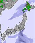 | 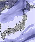 |  | 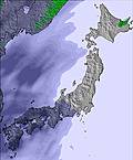 | 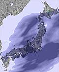 | 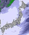 |  | |||||||||||||
— | — | — | — | — | — | — | — | — | — | — | — | — | — | — | — | — | — | — | — | |
1.0 | 6 | 3 | 2.0 | 2.0 | 2.0 | — | — | — | — | 13 | 1.0 | — | — | — | — | 4 | 1.0 | 1.0 | 4 | |
max°C | 5 | 6 | 7 | 4 | 3 | 6 | 4 | 3 | 9 | 9 | 5 | 6 | 6 | 5 | 12 | 11 | 6 | 6 | 4 | 3 |
min°C | 5 | 5 | 6 | 3 | 2 | 4 | 3 | 1 | 7 | 7 | 3 | 5 | 6 | 4 | 10 | 7 | 4 | 6 | 3 | 2 |
1 | 4 | 2 | -2 | -2 | 0 | -2 | -2 | 6 | 5 | -2 | 1 | 2 | 2 | 8 | 6 | 1 | 3 | -2 | -3 | |
88 | 81 | 97 | 97 | 96 | 90 | 73 | 73 | 46 | 45 | 93 | 92 | 64 | 63 | 54 | 62 | 94 | 71 | 83 | 72 | |
2050 | 2650 | 2450 | 1200 | 1100 | 1100 | 1100 | 2400 | 2500 | 2550 | 2150 | 1250 | 2550 | 2650 | 2700 | 2350 | 1600 | 1100 | 1000 | 1050 | |
— | — | 4:48 | — | — | 4:47 | — | — | 4:46 | — | — | 4:43 | — | — | 4:43 | — | — | 4:41 | — | — | |
6:22 | — | — | 6:23 | — | — | 6:24 | — | — | 6:27 | — | — | 6:28 | — | — | 6:29 | — | — | 6:30 | — | |
Moderate rain (total 16.0mm), heaviest on Sat night. Mild temperatures (max 9°C on Tue morning, min 1°C on Mon night). Winds decreasing (fresh winds from the SSW on Sat night, calm by Mon night).
Moderate rain (total 19.0mm), heaviest on Tue night. Very mild (max 12°C on Thu morning, min 3°C on Tue night). Wind will be generally light.
Latest snow reports near Rankoshi-cho Chisenupuri:
Rain and snow or hail reported from Kutchan at 179 metres elevation only 4 kms E of Niseko Hanazono Resort but it is probably falling as rain at the bottom of the ski area from Niseko Hanazono Resort
| Top snow depth: | — |
|---|---|
| Bottom snow depth: | — |
| Fresh snowfall depth: | — |
| Last snowfall: | 16 Apr 2025 |
| Snow Alerts | Create Alert |
0.1 | Bluebird Powder days Fresh snow, mostly sunny, light wind. |
|---|---|
0.6 | Powder days Fresh snow, limited sun, any wind. |
0.1 | Bluebird days Average snow, mostly sunny, light wind. |
The above table gives the weather forecast for Rankoshi-cho Chisenupuri at the specific elevation of 550 m. Our sophisticated weather models allow us to provide snow forecasts for the top, middle and bottom ski stations of Rankoshi-cho Chisenupuri. To access the weather forecasts for the other elevations, use the tab navigation above the table. For a wider view of the weather, check out the Weather Map of Japan.
Click here to read further information on freezing levels and how we forecast our temperatures.
The Rankoshi-cho Chisenupuri skiing weather widget is available to embed on external websites free of charge. It provides a daily summary of our Rankoshi-cho Chisenupuri snow forecast and current weather conditions. Simply go to the feed configuration page and follow the 3 simple steps to grab the custom html code snippet and paste it into your own site. You can choose the snow forecast elevation (summit, mid-mountain or bottom lift) and metric/imperial units for the snow forecast feed to suit your own website…. Click here to get the code.
View detailed snow forecast for Rankoshi-cho Chisenupuri at:
snow-forecast.com


 Nearest