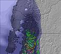
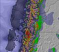
Patagonia Heliski Weather (Next 3 days): The snow forecast for Patagonia Heliski is: A heavy fall of snow, heaviest during Thu night. Temperatures will be below freezing (max 0°C on Thu morning, min -9°C on Thu night). Winds increasing (light winds from the WNW on Fri morning, severe gales from the W by Fri night).
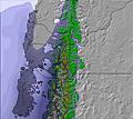
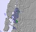
Patagonia Heliski Weather (Days 4-6): Mostly dry. Freeze-thaw conditions (max 5°C on Sun night, min -2°C on Tue night). Winds decreasing (fresh winds from the SSW on Sun morning, light winds from the WSW by Sun night).


 Nearest