
Pre-2025-Season Snowfall in Southern Hemisphere
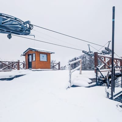
Ski areas on three continents across the southern hemisphere have been reporting fresh snowfall ahead of the 2025 season, which is now only a month away.
Please sign in with your Snow-Forecast account details below.


Niseko Moiwa Weather (Next 3 days): The snow forecast for Niseko Moiwa is: Heavy rain (total 28.0mm), heaviest during Mon night. Very mild (max 14°C on Thu morning, min 2°C on Mon night). Wind will be generally light.
Niseko Moiwa Weather (Days 4-6): Heavy rain (total 20.0mm), heaviest during Fri night. Very mild (max 14°C on Thu afternoon, min 6°C on Thu night). Winds increasing (light winds from the S on Thu afternoon, fresh winds from the S by Sun morning).
| Resort | Snow Depth | Temp. (°C) | Wind (km/h) | Weather | ||
|---|---|---|---|---|---|---|
| Top Lift: | 4 | |||||
| Middle Lift: | 5 | |||||
| Bottom Lift: | 5 |
Latest snow reports near Niseko Moiwa:
Continuous light rain reported from Kutchan at 179 metres elevation only 4 kms E of Niseko Hanazono Resort but it is forecast cold enough for snow at the ski area from Niseko Hanazono Resort

Mon 28 | Tuesday 29 | Wednesday 30 | Thursday 1 | Friday 2 | Saturday 3 | Sunday 4 | ||||||||||||||
PM | night | AM | PM | night | AM | PM | night | AM | PM | night | AM | PM | night | AM | PM | night | AM | PM | night | |
light rain | mod. rain | mod. rain | mod. rain | light rain | some clouds | some clouds | clear | clear | clear | some clouds | cloudy | cloudy | mod. rain | light rain | light rain | mod. rain | light rain | light rain | rain shwrs | |
km/h | ||||||||||||||||||||
Snow map |  |  |  |  |  |  |  | |||||||||||||
— | — | — | — | — | — | — | — | — | — | — | — | — | — | — | — | — | — | — | — | |
2.0 | 10 | 8 | 7 | 1.0 | — | — | — | — | — | — | — | — | 7 | 2.0 | 1.0 | 7 | 3 | 5 | 4 | |
max°C | 7 | 3 | 4 | 4 | 4 | 7 | 7 | 4 | 14 | 14 | 9 | 13 | 12 | 9 | 9 | 8 | 7 | 9 | 6 | 7 |
min°C | 5 | 2 | 3 | 4 | 3 | 5 | 5 | 2 | 11 | 9 | 6 | 11 | 10 | 7 | 9 | 7 | 6 | 8 | 6 | 6 |
2 | -1 | 0 | 3 | 3 | 2 | 3 | 0 | 11 | 8 | 4 | 8 | 7 | 5 | 7 | 4 | 2 | 4 | 2 | 2 | |
73 | 95 | 97 | 96 | 98 | 87 | 75 | 87 | 56 | 51 | 80 | 75 | 74 | 93 | 90 | 93 | 95 | 94 | 96 | 98 | |
1300 | 1300 | 1100 | 1250 | 1150 | 1450 | 1700 | 2700 | 2900 | 2950 | 2950 | 2800 | 2450 | 2100 | 1800 | 1950 | 1850 | 1800 | 1450 | 1450 | |
— | — | 4:35 | — | — | 4:33 | — | — | 4:31 | — | — | 4:31 | — | — | 4:30 | — | — | 4:28 | — | — | |
6:32 | — | — | 6:35 | — | — | 6:36 | — | — | 6:37 | — | — | 6:37 | — | — | 6:38 | — | — | 6:39 | — | |
Heavy rain (total 28.0mm), heaviest during Mon night. Very mild (max 14°C on Thu morning, min 2°C on Mon night). Wind will be generally light.
Heavy rain (total 20.0mm), heaviest during Fri night. Very mild (max 14°C on Thu afternoon, min 6°C on Thu night). Winds increasing (light winds from the S on Thu afternoon, fresh winds from the S by Sun morning).
Latest snow reports near Niseko Moiwa:
Continuous light rain reported from Kutchan at 179 metres elevation only 4 kms E of Niseko Hanazono Resort but it is forecast cold enough for snow at the ski area from Niseko Hanazono Resort
| Top snow depth: | — |
|---|---|
| Bottom snow depth: | — |
| Fresh snowfall depth: | 2 cm |
| Last snowfall: | 26 Apr 2025 |
| Snow Alerts | Create Alert |
0.0 | Bluebird Powder days Fresh snow, mostly sunny, light wind. |
|---|---|
0.0 | Powder days Fresh snow, limited sun, any wind. |
0.0 | Bluebird days Average snow, mostly sunny, light wind. |
The above table gives the weather forecast for Niseko Moiwa at the specific elevation of 330 m. Our sophisticated weather models allow us to provide snow forecasts for the top, middle and bottom ski stations of Niseko Moiwa. To access the weather forecasts for the other elevations, use the tab navigation above the table. For a wider view of the weather, check out the Weather Map of Japan.
Click here to read further information on freezing levels and how we forecast our temperatures.
The Niseko Moiwa skiing weather widget is available to embed on external websites free of charge. It provides a daily summary of our Niseko Moiwa snow forecast and current weather conditions. Simply go to the feed configuration page and follow the 3 simple steps to grab the custom html code snippet and paste it into your own site. You can choose the snow forecast elevation (summit, mid-mountain or bottom lift) and metric/imperial units for the snow forecast feed to suit your own website…. Click here to get the code.
View detailed snow forecast for Niseko Moiwa at:
snow-forecast.com


 Nearest