
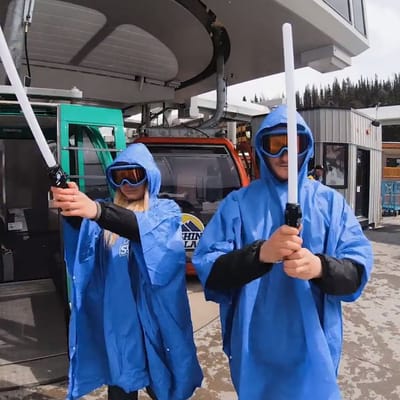
Ski Areas Ready for Star Wars Day
Several North American ski areas that are still open plan to celebrate the unofficial Star Wars Day tomorrow, May the Fourth (be with you).
Please sign in with your Snow-Forecast account details below.

Mt Voras Kaimaktsalan Weather (Next 3 days): The snow forecast for Mt Voras Kaimaktsalan is: Moderate rain (total 12.0mm), heaviest on Tue afternoon. Mild temperatures (max 8°C on Mon night, min 5°C on Mon morning). Winds increasing (light winds from the SSW on Mon morning, fresh winds from the WSW by Tue night).
Mt Voras Kaimaktsalan Weather (Days 4-6): Moderate rain (total 18.0mm), heaviest on Fri night. Mild temperatures (max 8°C on Fri afternoon, min 2°C on Sat night). Mainly fresh winds.
| Resort | Snow Depth | Temp. (°F) | Wind (mph) | Weather | ||
|---|---|---|---|---|---|---|
| Top Lift: | 43 | |||||
| Middle Lift: | 45 | |||||
| Bottom Lift: | 43 |
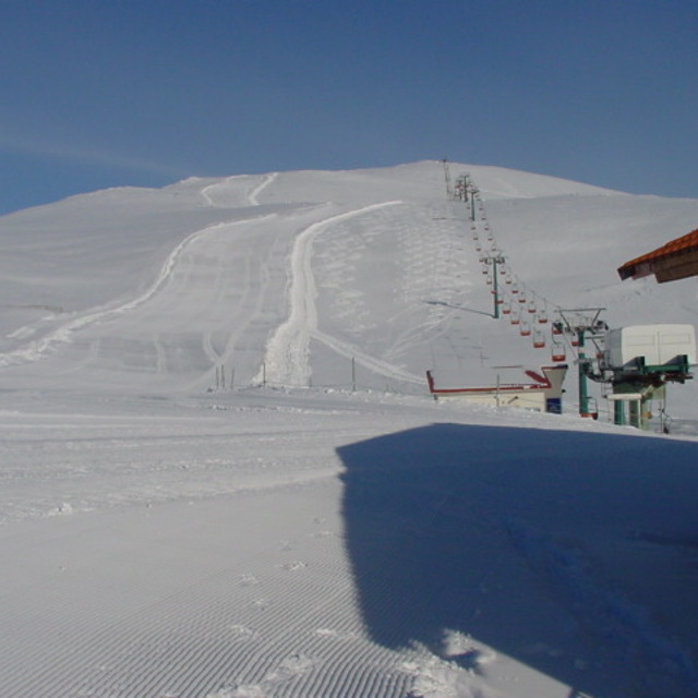
Latest snow reports near Mt Voras Kaimaktsalan:

Monday 5 | Tuesday 6 | Wednesday 7 | Thursday 8 | Friday 9 | Saturday 10 | Sunday 11 | |||||||||||||||
AM | PM | night | AM | PM | night | AM | PM | night | AM | PM | night | AM | PM | night | AM | PM | night | AM | PM | night | |
light rain | some clouds | some clouds | cloudy | risk thun- der | rain shwrs | risk thun- der | risk thun- der | some clouds | some clouds | cloudy | rain shwrs | some clouds | light rain | light rain | rain shwrs | risk thun- der | rain shwrs | clear | clear | light rain | |
mph | |||||||||||||||||||||
Snow map |  |  | 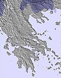 | 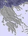 | 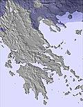 | 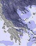 |  | ||||||||||||||
— | — | — | — | — | — | — | — | — | — | — | — | — | — | — | — | — | — | — | — | — | |
0.04 | — | — | — | 0.1 | 0.2 | 0.08 | 0.04 | — | — | — | 0.04 | — | 0.04 | 0.2 | 0.08 | 0.3 | 0.04 | — | — | 0.08 | |
max°F | 41 | 45 | 46 | 45 | 46 | 46 | 43 | 45 | 45 | 43 | 45 | 43 | 43 | 46 | 45 | 43 | 43 | 39 | 37 | 41 | 41 |
min°F | 41 | 43 | 45 | 45 | 46 | 43 | 43 | 45 | 41 | 41 | 43 | 43 | 41 | 45 | 43 | 41 | 43 | 36 | 36 | 41 | 37 |
37 | 36 | 37 | 39 | 41 | 36 | 36 | 37 | 36 | 36 | 37 | 37 | 36 | 37 | 36 | 34 | 36 | 27 | 28 | 36 | 32 | |
75 | 76 | 60 | 63 | 68 | 70 | 67 | 68 | 32 | 40 | 69 | 68 | 50 | 67 | 80 | 82 | 74 | 86 | 46 | 51 | 62 | |
9500 | 10700 | 11200 | 10700 | 10700 | 10300 | 9700 | 9800 | 11000 | 9800 | 9700 | 9800 | 10700 | 10800 | 11000 | 9700 | 10000 | 8900 | 9400 | 9700 | 9500 | |
6:26 | — | — | 6:24 | — | — | 6:24 | — | — | 6:22 | — | — | 6:22 | — | — | 6:20 | — | — | 6:20 | — | — | |
— | 8:32 | — | — | 8:34 | — | — | 8:35 | — | — | 8:36 | — | — | 8:37 | — | — | 8:37 | — | — | 8:38 | — | |
Moderate rain (total 12.0mm), heaviest on Tue afternoon. Mild temperatures (max 8°C on Mon night, min 5°C on Mon morning). Winds increasing (light winds from the SSW on Mon morning, fresh winds from the WSW by Tue night).
Moderate rain (total 18.0mm), heaviest on Fri night. Mild temperatures (max 8°C on Fri afternoon, min 2°C on Sat night). Mainly fresh winds.
Latest snow reports near Mt Voras Kaimaktsalan:
| Top snow depth: | — |
|---|---|
| Bottom snow depth: | — |
| Fresh snowfall depth: | — |
| Last snowfall: | 26 Apr 2025 |
| Snow Alerts | Create Alert |
0.2 | Bluebird Powder days Fresh snow, mostly sunny, light wind. |
|---|---|
0.3 | Powder days Fresh snow, limited sun, any wind. |
0.1 | Bluebird days Average snow, mostly sunny, light wind. |
The above table gives the weather forecast for Mt Voras Kaimaktsalan at the specific elevation of 2265 m. Our sophisticated weather models allow us to provide snow forecasts for the top, middle and bottom ski stations of Mt Voras Kaimaktsalan. To access the weather forecasts for the other elevations, use the tab navigation above the table. For a wider view of the weather, check out the Weather Map of Greece.
Click here to read further information on freezing levels and how we forecast our temperatures.
Overall 3.4 Based on 47 votes and 30 reviews
Eνα συγχρονο χιονοδρομικο σε ενα τοσο ομορφο τοπιο με απαραδεκτη διαχειριση....Τριτη ξαφνικα κλειστο με υπεροχο καιρο χωρις αερα ..δεν ξερω για καθημερινες γενικα.Ανοιχτο λεει μονο το babylift για ποιον και γω δεν γνωριζω.Τι ωραια εντυπωση σ αφηνει μια επιχειρηση οταν εχεις κανει 150 χιλιομετρα με φοβερη διαθεση και φτανεις και ειναι κλειστα. Απλα δεν ξαναπατας..Καλυτερα 3 5 πηγαδια με τεχνητο εστω χιονι.Ναουσα ,ελατοχωρι,Βασιλιτσα που το αγαπανε και το πονανε.Καιμακτσαλαν μονο για περπατημα.
Γιαννης from Greece writes:
Eνα συγχρονο χιονοδρομικο σε ενα τοσο ομορφο τοπιο με απαραδεκτη διαχειριση....Τριτη ξαφνικα κλειστο με υπεροχο καιρο χωρις αερα ..δεν ξερω για καθημερινες γενικα.Ανοιχτο λεει μονο το babylift για ποιον και γω δεν γνωριζω.Τι ωραια εντυπωση σ αφηνει μια επιχειρηση οταν εχεις κανει 150 χιλιομετρα με φοβερη διαθεση και φτανεις και ειναι κλειστα.
Απλα δεν ξαναπατας..Καλυτερα 3 5 πηγαδια με τεχνητο εστω χιονι.Ναουσα ,ελατοχωρι,Βασιλιτσα που το αγαπανε και το πονανε.Καιμακτσαλαν μονο για περπατημα.
Read 29 more reviews of Mt Voras Kaimaktsalan or submit your own
The Mt Voras Kaimaktsalan skiing weather widget is available to embed on external websites free of charge. It provides a daily summary of our Mt Voras Kaimaktsalan snow forecast and current weather conditions. Simply go to the feed configuration page and follow the 3 simple steps to grab the custom html code snippet and paste it into your own site. You can choose the snow forecast elevation (summit, mid-mountain or bottom lift) and metric/imperial units for the snow forecast feed to suit your own website…. Click here to get the code.
View detailed snow forecast for Mt Voras Kaimaktsalan at:
snow-forecast.com


 Nearest