
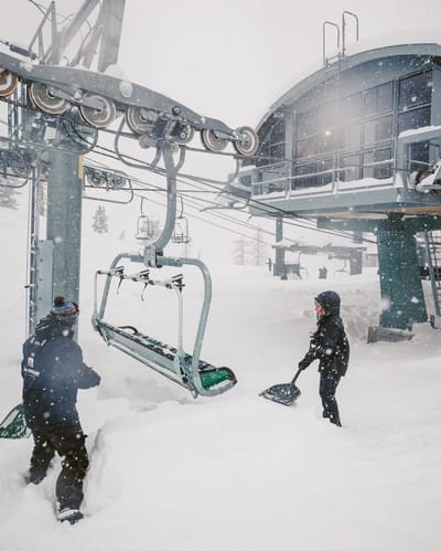
Over A Metre (40”) Of Snowfall in 24 Hours At Californian Ski Area
California has had some huge snowfalls, as forecast, over the last 24 hours.
Please sign in with your Snow-Forecast account details below.

Menthières Weather (Next 3 days): The snow forecast for Menthières is: A moderate fall of snow, heaviest on Sat afternoon. Temperatures will be below freezing (max -1°C on Sun night, min -3°C on Fri night). Wind will be generally light.
Menthières Weather (Days 4-6): Mostly dry. Mild temperatures (max 7°C on Thu afternoon, min 1°C on Mon night). Wind will be generally light.
| Resort | Snow Depth | Temp. (°C) | Wind (km/h) | Weather | ||
|---|---|---|---|---|---|---|
| Top Lift: | -3 | |||||
| Middle Lift: | -2 | |||||
| Bottom Lift: | -1 |
Latest snow reports near Menthières:
Light rain reported from Haute-Savoie Mont Blanc Airport/Aéroport Annecy/Meythet at 711 metres elevation only 3 kms WNW of Annecy-LeSemnoz but it is forecast cold enough for snow at the ski area from Annecy-LeSemnoz

Saturday 15 | Sunday 16 | Monday 17 | Tuesday 18 | Wednesday 19 | Thursday 20 | ||||||||||||||
night | AM | PM | night | AM | PM | night | AM | PM | night | AM | PM | night | AM | PM | night | AM | PM | night | |
light snow | light snow | light snow | light snow | light snow | light snow | cloudy | light snow | some clouds | clear | clear | clear | clear | clear | some clouds | clear | some clouds | some clouds | cloudy | |
km/h | |||||||||||||||||||
Snow map |  |  |  |  |  |  |  | ||||||||||||
4 | 4 | 4 | 4 | — | — | — | — | — | — | — | — | — | — | — | — | — | — | — | |
— | — | — | — | — | — | — | — | — | — | — | — | — | — | — | — | — | — | — | |
max°C | -2 | -2 | -2 | -2 | -3 | -2 | -1 | -2 | -1 | 2 | 4 | 4 | 3 | 4 | 5 | 4 | 6 | 7 | 9 |
min°C | -3 | -3 | -2 | -3 | -3 | -2 | -3 | -3 | -1 | 1 | 3 | 4 | 2 | 4 | 5 | 4 | 6 | 7 | 7 |
-8 | -7 | -6 | -5 | -3 | -2 | -7 | -6 | -4 | -1 | 2 | 4 | 2 | 4 | 5 | 3 | 4 | 4 | 4 | |
98 | 98 | 99 | 98 | 99 | 96 | 93 | 97 | 97 | 63 | 64 | 82 | 89 | 74 | 78 | 75 | 62 | 69 | 64 | |
950 | 900 | 1000 | 900 | 800 | 1000 | 1000 | 950 | 1200 | 1800 | 2000 | 1950 | 1850 | 1950 | 2100 | 2200 | 2350 | 2550 | 2850 | |
— | 6:50 | — | — | 6:48 | — | — | 6:46 | — | — | 6:43 | — | — | 6:41 | — | — | 6:39 | — | — | |
— | — | 6:40 | — | — | 6:43 | — | — | 6:44 | — | — | 6:45 | — | — | 6:46 | — | — | 6:47 | — | |
A moderate fall of snow, heaviest on Sat afternoon. Temperatures will be below freezing (max -1°C on Sun night, min -3°C on Fri night). Wind will be generally light.
Mostly dry. Mild temperatures (max 7°C on Thu afternoon, min 1°C on Mon night). Wind will be generally light.
Latest snow reports near Menthières:
Light rain reported from Haute-Savoie Mont Blanc Airport/Aéroport Annecy/Meythet at 711 metres elevation only 3 kms WNW of Annecy-LeSemnoz but it is forecast cold enough for snow at the ski area from Annecy-LeSemnoz
| Top snow depth: | — |
|---|---|
| Bottom snow depth: | — |
| Fresh snowfall depth: | 1 cm |
| Last snowfall: | 13 Mar 2025 |
| Snow Alerts | Create Alert |
0.1 | Bluebird Powder days Fresh snow, mostly sunny, light wind. |
|---|---|
0.5 | Powder days Fresh snow, limited sun, any wind. |
0.7 | Bluebird days Average snow, mostly sunny, light wind. |
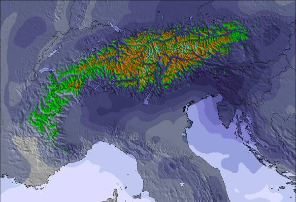
The above table gives the weather forecast for Menthières at the specific elevation of 1298 m. Our sophisticated weather models allow us to provide snow forecasts for the top, middle and bottom ski stations of Menthières. To access the weather forecasts for the other elevations, use the tab navigation above the table. For a wider view of the weather, check out the Weather Map of France.
Click here to read further information on freezing levels and how we forecast our temperatures.
Resort name is also written as Menthieres.
The Menthières skiing weather widget is available to embed on external websites free of charge. It provides a daily summary of our Menthières snow forecast and current weather conditions. Simply go to the feed configuration page and follow the 3 simple steps to grab the custom html code snippet and paste it into your own site. You can choose the snow forecast elevation (summit, mid-mountain or bottom lift) and metric/imperial units for the snow forecast feed to suit your own website…. Click here to get the code.
View detailed snow forecast for Menthières at:
snow-forecast.com

 Nearest