

Ski Areas Ready for Star Wars Day
Several North American ski areas that are still open plan to celebrate the unofficial Star Wars Day tomorrow, May the Fourth (be with you).
Please sign in with your Snow-Forecast account details below.


Loveland Weather (Next 3 days): The snow forecast for Loveland is: Mild with light rain (total 2.0mm) on Sun afternoon Becoming colder with a light covering of snow, mostly falling on Mon afternoon. Freeze-thaw conditions (max 9°C on Sat afternoon, min -4°C on Sun night). Wind will be generally light.
Loveland Weather (Days 4-6): A light covering of new snow, mostly falling on Tue night. Becoming milder with light rain (total 3.0mm) on Wed afternoon. Freeze-thaw conditions (max 7°C on Thu afternoon, min -6°C on Mon night). Wind will be generally light.
| Resort | Snow Depth | Temp. (°F) | Wind (mph) | Weather | ||
|---|---|---|---|---|---|---|
| Top Lift: | 5 ft | 21 | ||||
| Middle Lift: | 25 | |||||
| Bottom Lift: | 5 ft | 27 |
Latest snow reports near Loveland:

Saturday 3 | Sunday 4 | Monday 5 | Tuesday 6 | Wednesday 7 | Thursday 8 | ||||||||||||||
night | AM | PM | night | AM | PM | night | AM | PM | night | AM | PM | night | AM | PM | night | AM | PM | night | |
clear | clear | some clouds | some clouds | some clouds | risk thun- der | snow shwrs | light snow | snow shwrs | light snow | snow shwrs | light snow | mod. snow | light snow | snow shwrs | snow shwrs | some clouds | light rain | snow shwrs | |
mph | |||||||||||||||||||
Snow map |  |  |  |  |  |  |  | ||||||||||||
— | — | — | — | — | — | 0.4 | 0.4 | 1 | — | — | 0.4 | 2 | — | — | — | — | — | — | |
— | — | — | — | — | 0.08 | — | — | — | — | — | — | — | — | 0.04 | — | — | 0.08 | — | |
max°F | 28 | 46 | 48 | 34 | 46 | 45 | 30 | 36 | 34 | 25 | 36 | 36 | 28 | 36 | 36 | 27 | 41 | 45 | 34 |
min°F | 27 | 39 | 45 | 30 | 43 | 37 | 25 | 34 | 32 | 21 | 30 | 32 | 23 | 30 | 36 | 25 | 36 | 41 | 30 |
27 | 37 | 43 | 25 | 39 | 32 | 19 | 28 | 25 | 21 | 27 | 28 | 23 | 25 | 32 | 25 | 32 | 37 | 30 | |
45 | 24 | 20 | 71 | 37 | 41 | 93 | 72 | 76 | 89 | 58 | 65 | 96 | 68 | 65 | 86 | 64 | 43 | 92 | |
9800 | 12300 | 13800 | 10700 | 12800 | 13300 | 10700 | 11000 | 11000 | 9000 | 10300 | 11300 | 9700 | 10000 | 11500 | 9500 | 11800 | 13800 | 11000 | |
— | 6:01 | — | — | 6:01 | — | — | 5:58 | — | — | 5:58 | — | — | 5:56 | — | — | 5:56 | — | — | |
— | — | 7:59 | — | — | 8:00 | — | — | 8:00 | — | — | 8:01 | — | — | 8:02 | — | — | 8:04 | — | |
Mild with light rain (total 2.0mm) on Sun afternoon Becoming colder with a light covering of snow, mostly falling on Mon afternoon. Freeze-thaw conditions (max 9°C on Sat afternoon, min -4°C on Sun night). Wind will be generally light.
A light covering of new snow, mostly falling on Tue night. Becoming milder with light rain (total 3.0mm) on Wed afternoon. Freeze-thaw conditions (max 7°C on Thu afternoon, min -6°C on Mon night). Wind will be generally light.
Latest snow reports near Loveland:
| Top snow depth: | 61 in |
|---|---|
| Bottom snow depth: | 61 in |
| Fresh snowfall depth: | 3 in |
| Last snowfall: | 30 Apr 2025 |
| Snow Alerts | Create Alert |
0.3 | Bluebird Powder days Fresh snow, mostly sunny, light wind. |
|---|---|
1.6 | Powder days Fresh snow, limited sun, any wind. |
0.5 | Bluebird days Average snow, mostly sunny, light wind. |

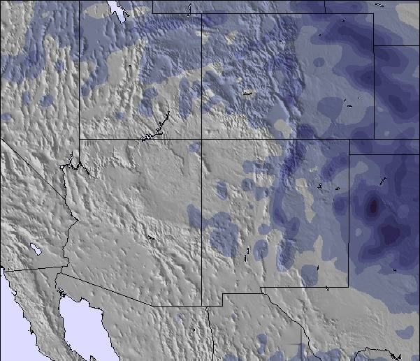
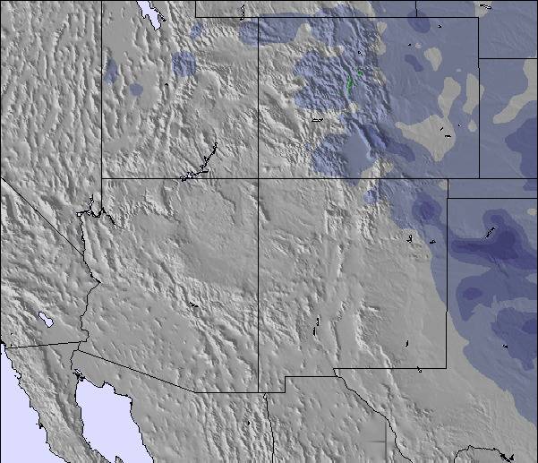
The above table gives the weather forecast for Loveland at the specific elevation of 3231 m. Our sophisticated weather models allow us to provide snow forecasts for the top, middle and bottom ski stations of Loveland. To access the weather forecasts for the other elevations, use the tab navigation above the table. For a wider view of the weather, check out the Weather Map of United States.
Click here to read further information on freezing levels and how we forecast our temperatures.
The Loveland skiing weather widget is available to embed on external websites free of charge. It provides a daily summary of our Loveland snow forecast and current weather conditions. Simply go to the feed configuration page and follow the 3 simple steps to grab the custom html code snippet and paste it into your own site. You can choose the snow forecast elevation (summit, mid-mountain or bottom lift) and metric/imperial units for the snow forecast feed to suit your own website…. Click here to get the code.
View detailed snow forecast for Loveland at:
snow-forecast.com

 Nearest