

French Ski Areas Announce 2025 Summer Ski Plans
Three French ski areas have announced their opening plans in May, June and July after the winter season ends on May 4th.
Please sign in with your Snow-Forecast account details below.
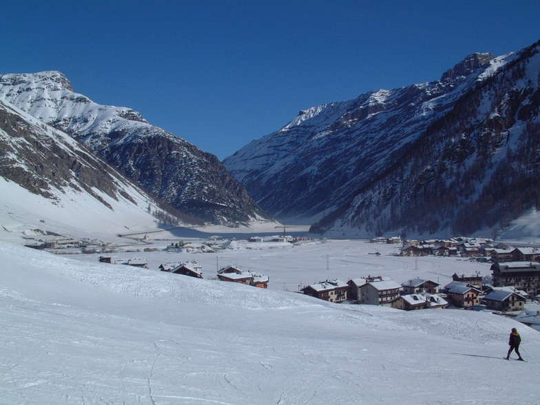


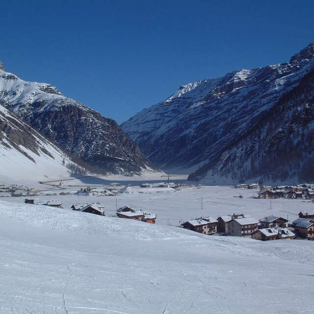
Livigno Weather (Next 3 days): The snow forecast for Livigno is: A dusting of snow giving way to moderate rain (total 14.0mm) heaviest on Thu night. Freeze-thaw conditions (max 4°C on Thu morning, min 0°C on Tue night). Wind will be generally light.
Livigno Weather (Days 4-6): Drizzle on Fri afternoon followed by colder weather and a heavy fall of snow, heaviest during Sun morning. Freeze-thaw conditions (max 2°C on Fri morning, min -3°C on Sun morning). Wind will be generally light.
| Resort | Snow Depth | Temp. (°C) | Wind (km/h) | Weather | ||
|---|---|---|---|---|---|---|
| Top Lift: | 0.8 m | -2 | ||||
| Middle Lift: | 1 | |||||
| Bottom Lift: | 3 |
Latest snow reports near Livigno:
Intermittent light rain reported from Samedan Airport at 1706 metres elevation 6 kms S of La Punt/Engadin but it is forecast cold enough for snow at higher elevations in the ski area from La Punt/Engadin
Intermittent light rain reported from Samedan Airport at 1706 metres elevation only 3 kms NE of Corviglia-Marguns but it is forecast cold enough for snow at higher elevations in the ski area from Corviglia-Marguns
Drizzle reported from Samedan Airport at 1706 metres elevation only 2 kms NE of Celerina/Engadin but it is forecast cold enough for snow at higher elevations in the ski area from Celerina/Engadin

Tuesday 15 | Wednesday 16 | Thursday 17 | Friday 18 | Saturday 19 | Sunday 20 | Monday 21 | |||||||||||||||
AM | PM | night | AM | PM | night | AM | PM | night | AM | PM | night | AM | PM | night | AM | PM | night | AM | PM | night | |
light snow | light snow | light snow | cloudy | light rain | light snow | light rain | light rain | mod. rain | light snow | light rain | cloudy | light snow | light snow | mod. snow | mod. snow | light snow | light snow | cloudy | light snow | light snow | |
km/h | |||||||||||||||||||||
Snow map |  |  |  |  |  |  |  | ||||||||||||||
— | 2.0 | — | — | — | 1.0 | — | — | — | 1.0 | — | — | — | — | 7 | 8 | 2.0 | 2.0 | — | — | 3 | |
— | — | — | — | 2.0 | 1.0 | 2.0 | 3 | 6 | — | 1.0 | — | — | — | — | — | — | — | — | — | — | |
max°C | 1 | 2 | 1 | 1 | 3 | 2 | 4 | 4 | 3 | 2 | 2 | 2 | 1 | 2 | 1 | -3 | -1 | -2 | -3 | 0 | -1 |
min°C | 1 | 2 | 0 | 1 | 3 | 2 | 2 | 4 | 2 | 2 | 2 | 0 | 0 | 2 | -2 | -3 | -1 | -3 | -4 | -1 | -2 |
-2 | -2 | -5 | -4 | 0 | -1 | -1 | 2 | 0 | 0 | -1 | -4 | -4 | -2 | -2 | -3 | -4 | -7 | -9 | -5 | -5 | |
98 | 98 | 97 | 94 | 90 | 95 | 93 | 96 | 97 | 95 | 92 | 91 | 94 | 92 | 98 | 95 | 96 | 92 | 93 | 94 | 97 | |
2550 | 2650 | 2350 | 2500 | 2700 | 2650 | 2850 | 2850 | 2700 | 2600 | 2600 | 2450 | 2450 | 2550 | 2300 | 1850 | 2200 | 1850 | 1900 | 2300 | 2050 | |
6:33 | — | — | 6:31 | — | — | 6:30 | — | — | 6:28 | — | — | 6:26 | — | — | 6:24 | — | — | 6:22 | — | — | |
— | — | 8:06 | — | — | 8:07 | — | — | 8:08 | — | — | 8:09 | — | — | 8:10 | — | — | 8:13 | — | — | 8:14 | |
A dusting of snow giving way to moderate rain (total 14.0mm) heaviest on Thu night. Freeze-thaw conditions (max 4°C on Thu morning, min 0°C on Tue night). Wind will be generally light.
Drizzle on Fri afternoon followed by colder weather and a heavy fall of snow, heaviest during Sun morning. Freeze-thaw conditions (max 2°C on Fri morning, min -3°C on Sun morning). Wind will be generally light.
Latest snow reports near Livigno:
Intermittent light rain reported from Samedan Airport at 1706 metres elevation 6 kms S of La Punt/Engadin but it is forecast cold enough for snow at higher elevations in the ski area from La Punt/Engadin
Intermittent light rain reported from Samedan Airport at 1706 metres elevation only 3 kms NE of Corviglia-Marguns but it is forecast cold enough for snow at higher elevations in the ski area from Corviglia-Marguns
Drizzle reported from Samedan Airport at 1706 metres elevation only 2 kms NE of Celerina/Engadin but it is forecast cold enough for snow at higher elevations in the ski area from Celerina/Engadin
| Top snow depth: | 78 cm |
|---|---|
| Bottom snow depth: | — |
| Fresh snowfall depth: | 4 cm |
| Last snowfall: | 14 Apr 2025 |
| Snow Alerts | Create Alert |
0.6 | Bluebird Powder days Fresh snow, mostly sunny, light wind. |
|---|---|
1.4 | Powder days Fresh snow, limited sun, any wind. |
0.7 | Bluebird days Average snow, mostly sunny, light wind. |
The above table gives the weather forecast for Livigno at the specific elevation of 2306 m. Our sophisticated weather models allow us to provide snow forecasts for the top, middle and bottom ski stations of Livigno. To access the weather forecasts for the other elevations, use the tab navigation above the table. For a wider view of the weather, check out the Weather Map of Italy.
Click here to read further information on freezing levels and how we forecast our temperatures.
Overall 4.6 Based on 60 votes and 77 reviews
This year me and 11 other friends decided to do our ski vacation in Livigno because the date that worked out for us was the beginning of December And I must say we had a lot of fun. It was a bit of a gamble but there was enough snow to open most of the site and as we have only been skiing for 5 years it was definitely enough for us Everything is well maintained and taken care of. The emptiest time of the year. We didn't wait more than 2 minutes in any elevator or gondola. I recommend finding out before going out when there is no traffic, it's just a pleasure to surf the site almost alone There were quantities of new off-piste that no human foot had touched...
Ezra from Israel writes:
This year me and 11 other friends decided to do our ski vacation in Livigno because the date that worked out for us was the beginning of December
And I must say we had a lot of fun. It was a bit of a gamble but there was enough snow to open most of the site and as we have only been skiing for 5 years it was definitely enough for us
Everything is well maintained and taken care of. The emptiest time of the year. We didn't wait more than 2 minutes in any elevator or gondola.
I recommend finding out before going out when there is no traffic, it's just a pleasure to surf the site almost alone
There were quantities of new off-piste that no human foot had touched...
The Livigno skiing weather widget is available to embed on external websites free of charge. It provides a daily summary of our Livigno snow forecast and current weather conditions. Simply go to the feed configuration page and follow the 3 simple steps to grab the custom html code snippet and paste it into your own site. You can choose the snow forecast elevation (summit, mid-mountain or bottom lift) and metric/imperial units for the snow forecast feed to suit your own website…. Click here to get the code.
View detailed snow forecast for Livigno at:
snow-forecast.com


 Nearest