

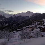
French Ski Areas Announce 2025 Summer Ski Plans
Three French ski areas have announced their opening plans in May, June and July after the winter season ends on May 4th.
Please sign in with your Snow-Forecast account details below.


La Tania Weather (Next 3 days): The snow forecast for La Tania is: Moderate rain (total 19.0mm), heaviest on Sun night. Mild temperatures (max 6°C on Tue afternoon, min 2°C on Tue night). Wind will be generally light.
La Tania Weather (Days 4-6): Mild with heavy rain (total 21.0mm), heaviest during Fri night. Becoming colder with a moderate fall of snow heaviest on Fri night. Freeze-thaw conditions (max 6°C on Fri morning, min -2°C on Wed night). Wind will be generally light.
| Resort | Snow Depth | Temp. (°C) | Wind (km/h) | Weather | ||
|---|---|---|---|---|---|---|
| Top Lift: | 0 | |||||
| Middle Lift: | 4 | |||||
| Bottom Lift: | 7 |
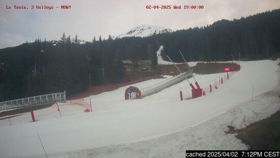
Latest snow reports near La Tania:
Partly cloudy at Val d'Isere. Very windy today. Thaw. No new snow. from Val d'Isere
Great on piste conditions, okay conditions off piste. Overcast skies, mild temperatures. from Val Thorens

Sunday 13 | Monday 14 | Tuesday 15 | Wednesday 16 | Thursday 17 | Friday 18 | Saturday 19 | |||||||||||||||
AM | PM | night | AM | PM | night | AM | PM | night | AM | PM | night | AM | PM | night | AM | PM | night | AM | PM | night | |
some clouds | light rain | mod. rain | some clouds | some clouds | cloudy | light rain | rain shwrs | light rain | light snow | light snow | mod. snow | light snow | cloudy | rain shwrs | clear | rain shwrs | light snow | mod. snow | light snow | light snow | |
km/h | |||||||||||||||||||||
Snow map |  |  |  |  |  |  |  | ||||||||||||||
— | — | — | — | — | — | — | — | — | 2.0 | 4 | 5 | — | — | — | — | — | 4 | 6 | 3 | 5 | |
— | 4 | 7 | — | — | — | 2.0 | 2.0 | 4 | — | — | — | — | — | 3 | — | 3 | 15 | — | — | — | |
max°C | 4 | 5 | 3 | 5 | 5 | 4 | 3 | 6 | 5 | 1 | 0 | 0 | 2 | 3 | 3 | 6 | 6 | 4 | 0 | -1 | -3 |
min°C | 3 | 3 | 3 | 3 | 5 | 3 | 3 | 5 | 2 | 0 | -1 | -2 | 0 | 2 | 3 | 3 | 6 | 1 | 0 | -2 | -4 |
3 | 3 | 3 | 2 | 4 | 0 | 1 | 3 | -1 | 0 | -1 | -4 | 0 | 2 | 3 | 1 | 5 | 1 | 0 | -4 | -4 | |
84 | 97 | 92 | 78 | 77 | 80 | 89 | 68 | 87 | 99 | 98 | 96 | 92 | 97 | 89 | 81 | 81 | 98 | 99 | 98 | 97 | |
2650 | 2600 | 2550 | 2700 | 2700 | 2650 | 2550 | 2750 | 2450 | 2150 | 1800 | 1700 | 2550 | 2650 | 2900 | 3000 | 2850 | 2450 | 1950 | 1600 | 1300 | |
6:52 | — | — | 6:50 | — | — | 6:48 | — | — | 6:47 | — | — | 6:46 | — | — | 6:43 | — | — | 6:41 | — | — | |
— | — | 8:15 | — | — | 8:16 | — | — | 8:17 | — | — | 8:20 | — | — | 8:21 | — | — | 8:22 | — | — | 8:23 | |
Moderate rain (total 19.0mm), heaviest on Sun night. Mild temperatures (max 6°C on Tue afternoon, min 2°C on Tue night). Wind will be generally light.
Mild with heavy rain (total 21.0mm), heaviest during Fri night. Becoming colder with a moderate fall of snow heaviest on Fri night. Freeze-thaw conditions (max 6°C on Fri morning, min -2°C on Wed night). Wind will be generally light.
Latest snow reports near La Tania:
Partly cloudy at Val d'Isere. Very windy today. Thaw. No new snow. from Val d'Isere
Great on piste conditions, okay conditions off piste. Overcast skies, mild temperatures. from Val Thorens
| Top snow depth: | — |
|---|---|
| Bottom snow depth: | — |
| Fresh snowfall depth: | — |
| Last snowfall: | 9 Apr 2025 |
| Snow Alerts | Create Alert |
0.8 | Bluebird Powder days Fresh snow, mostly sunny, light wind. |
|---|---|
0.6 | Powder days Fresh snow, limited sun, any wind. |
0.4 | Bluebird days Average snow, mostly sunny, light wind. |


The above table gives the weather forecast for La Tania at the specific elevation of 2038 m. Our sophisticated weather models allow us to provide snow forecasts for the top, middle and bottom ski stations of La Tania. To access the weather forecasts for the other elevations, use the tab navigation above the table. For a wider view of the weather, check out the Weather Map of France.
Click here to read further information on freezing levels and how we forecast our temperatures.
Overall 3.9 Based on 24 votes and 24 reviews
15 years since going to the 3 valleys after vowing never to go to France again after getting fed up with being ripped off -self catered chalet in La Tania not something I’d usually do as not keen on cooking after skiing, but in fairness the couple of restaurants in the village were reasonably priced and varied enough for a week and apres at Le Pub with a band at 5ish most nights worked well. Three valleys skiing is renowned and was never too busy anywhere, but realistically the ski area is just too big for most people and you find yourselves rushing to get somewhere else all day. Lack of recent snow led to some horrid ice wall reds over Meriibel side and the transition runs through Meribel and Mot Terry were hell by lunchtime with bodies all over the place. To be honest the best skiing was Courcheval side and I’d stick with the resort lift pass as there’s plenty that side to keep you amused if I were going again, but realistically you get a lot more holiday for your buck in Austria and Italy.
C roberts from United Kingdom writes:
15 years since going to the 3 valleys after vowing never to go to France again after getting fed up with being ripped off -self catered chalet in La Tania not something I’d usually do as not keen on cooking after skiing, but in fairness the couple of restaurants in the village were reasonably priced and varied enough for a week and apres at Le Pub with a band at 5ish most nights worked well. Three valleys skiing is renowned and was never too busy anywhere, but realistically the ski area is just too big for most people and you find yourselves rushing to get somewhere else all day. Lack of recent snow led to some horrid ice wall reds over Meriibel side and the transition runs through Meribel and Mot Terry were hell by lunchtime with bodies all over the place. To be honest the best skiing was Courcheval side and I’d stick with the resort lift pass as there’s plenty that side to keep you amused if I were going again, but realistically you get a lot more holiday for your buck in Austria and Italy.
The La Tania skiing weather widget is available to embed on external websites free of charge. It provides a daily summary of our La Tania snow forecast and current weather conditions. Simply go to the feed configuration page and follow the 3 simple steps to grab the custom html code snippet and paste it into your own site. You can choose the snow forecast elevation (summit, mid-mountain or bottom lift) and metric/imperial units for the snow forecast feed to suit your own website…. Click here to get the code.
View detailed snow forecast for La Tania at:
snow-forecast.com


 Nearest