
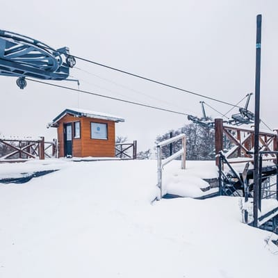
Pre-2025-Season Snowfall in Southern Hemisphere
Ski areas on three continents across the southern hemisphere have been reporting fresh snowfall ahead of the 2025 season, which is now only a month away.
Please sign in with your Snow-Forecast account details below.

Kanzelwand-Fellhorn (Kleinwalsertal) Weather (Next 3 days): The snow forecast for Kanzelwand-Fellhorn (Kleinwalsertal) is: Moderate rain (total 12.0mm), heaviest on Tue afternoon. Very mild (max 16°C on Thu afternoon, min 9°C on Tue morning). Wind will be generally light.
Kanzelwand-Fellhorn (Kleinwalsertal) Weather (Days 4-6): Heavy rain (total 40.0mm), heaviest during Sat night. Very mild (max 19°C on Sat afternoon, min 8°C on Sun night). Wind will be generally light.
| Resort | Snow Depth | Temp. (°C) | Wind (km/h) | Weather | ||
|---|---|---|---|---|---|---|
| Top Lift: | 6 | |||||
| Middle Lift: | 9 | |||||
| Bottom Lift: | 11 |
Latest snow reports near Kanzelwand-Fellhorn (Kleinwalsertal):

Tuesday 29 | Wednesday 30 | Thursday 1 | Friday 2 | Saturday 3 | Sunday 4 | Monday 5 | |||||||||||||||
AM | PM | night | AM | PM | night | AM | PM | night | AM | PM | night | AM | PM | night | AM | PM | night | AM | PM | night | |
clear | risk thun- der | rain shwrs | clear | risk thun- der | rain shwrs | clear | some clouds | rain shwrs | clear | clear | some clouds | cloudy | some clouds | heavy rain | light rain | risk thun- der | heavy rain | light rain | light rain | light rain | |
km/h | |||||||||||||||||||||
Snow map |  |  |  |  |  |  |  | ||||||||||||||
— | — | — | — | — | — | — | — | — | — | — | — | — | — | — | — | — | — | — | — | — | |
— | 4 | 3 | — | 1.0 | 2.0 | — | — | 2.0 | — | — | — | — | — | 16 | 3 | 4 | 17 | 3 | 2.0 | 2.0 | |
max°C | 11 | 13 | 11 | 12 | 15 | 12 | 13 | 16 | 14 | 15 | 18 | 15 | 18 | 19 | 15 | 12 | 14 | 11 | 8 | 9 | 7 |
min°C | 9 | 13 | 9 | 10 | 14 | 11 | 11 | 16 | 12 | 13 | 18 | 14 | 15 | 18 | 10 | 11 | 13 | 8 | 8 | 8 | 5 |
9 | 12 | 9 | 10 | 14 | 11 | 11 | 16 | 12 | 13 | 18 | 14 | 15 | 18 | 9 | 11 | 13 | 8 | 8 | 7 | 5 | |
63 | 57 | 70 | 58 | 54 | 70 | 57 | 46 | 69 | 40 | 29 | 49 | 33 | 49 | 83 | 81 | 60 | 91 | 96 | 86 | 90 | |
2950 | 3000 | 3050 | 3050 | 3100 | 3250 | 3250 | 3350 | 3400 | 3400 | 3650 | 3700 | 3650 | 3700 | 3100 | 3050 | 3300 | 2950 | 2850 | 2700 | 2300 | |
6:07 | — | — | 6:05 | — | — | 6:03 | — | — | 6:01 | — | — | 6:00 | — | — | 5:58 | — | — | 5:56 | — | — | |
— | — | 8:25 | — | — | 8:28 | — | — | 8:29 | — | — | 8:30 | — | — | 8:31 | — | — | 8:32 | — | — | 8:35 | |
Moderate rain (total 12.0mm), heaviest on Tue afternoon. Very mild (max 16°C on Thu afternoon, min 9°C on Tue morning). Wind will be generally light.
Heavy rain (total 40.0mm), heaviest during Sat night. Very mild (max 19°C on Sat afternoon, min 8°C on Sun night). Wind will be generally light.
Latest snow reports near Kanzelwand-Fellhorn (Kleinwalsertal):
| Top snow depth: | — |
|---|---|
| Bottom snow depth: | — |
| Fresh snowfall depth: | — |
| Last snowfall: | 18 Apr 2025 |
| Snow Alerts | Create Alert |
0.1 | Bluebird Powder days Fresh snow, mostly sunny, light wind. |
|---|---|
0.6 | Powder days Fresh snow, limited sun, any wind. |
0.1 | Bluebird days Average snow, mostly sunny, light wind. |
The above table gives the weather forecast for Kanzelwand-Fellhorn (Kleinwalsertal) at the specific elevation of 1510 m. Our sophisticated weather models allow us to provide snow forecasts for the top, middle and bottom ski stations of Kanzelwand-Fellhorn (Kleinwalsertal). To access the weather forecasts for the other elevations, use the tab navigation above the table. For a wider view of the weather, check out the Weather Map of Austria.
Click here to read further information on freezing levels and how we forecast our temperatures.
Overall 3.9 Based on 1 vote and 1 review
A skiing area that is part of the Oberstdorf / Kleinwalsertal resort. It's not huge in size, but there are some very nice and well-maintained pistes, mostly quite high up. We visited in February '12, and as in most of the Alps there was loads of snow - so much that for a couple of days all the upper lifts were closed due to avalanche risk. The skiing area straddles the German / Austrian border and most of the skiing is just on the German side. There are two ways of starting skiing here: one way from Oberstdorf is drive up the Kleinwalsertal road into Austria to Riezlern and catch the long gondola (signs for Kanzelwandbahn) to the top. There is a long (about 4.5Km) red piste that comes to the bottom there with a small fun park. At the top you can then link to the Fellhorn area in Germany which has a similar length but to my mind slightly steeper piste down to the German valley. To start skiing from the German side (there's slightly more parking) head for the signs to Fellhorn or Skiflugschanze. This will take you past the cross country skiing area and the huge ski flying stadium (not the ski-jumping Erdinger arena on the other side of town). It's about the same distance either way. Up the mountain the uplift is fairly standard, mostly chairs. There are some unpisted "Skirouten" which demand some technique and some nice cruisy reds and blues. One or two bits are labelled black but aren't very long or too demanding. There is a largish fun park (Almdudler sponsored, so follow those signs). There are nice huts - I liked the one just down the Austrian side for its stunning views. There are some good webcams and livecams on das-hoechste.de which also provides latest piste status and info. All in all, I liked it here. Good family skiing.
Andrew from United Kingdom writes:
A skiing area that is part of the Oberstdorf / Kleinwalsertal resort. It's not huge in size, but there are some very nice and well-maintained pistes, mostly quite high up. We visited in February '12, and as in most of the Alps there was loads of snow - so much that for a couple of days all the upper lifts were closed due to avalanche risk.
The skiing area straddles the German / Austrian border and most of the skiing is just on the German side. There are two ways of starting skiing here: one way from Oberstdorf is drive up the Kleinwalsertal road into Austria to Riezlern and catch the long gondola (signs for Kanzelwandbahn) to the top. There is a long (about 4.5Km) red piste that comes to the bottom there with a small fun park. At the top you can then link to the Fellhorn area in Germany which has a similar length but to my mind slightly steeper piste down to the German valley. To start skiing from the German side (there's slightly more parking) head for the signs to Fellhorn or Skiflugschanze. This will take you past the cross country skiing area and the huge ski flying stadium (not the ski-jumping Erdinger arena on the other side of town). It's about the same distance either way.
Up the mountain the uplift is fairly standard, mostly chairs. There are some unpisted "Skirouten" which demand some technique and some nice cruisy reds and blues. One or two bits are labelled black but aren't very long or too demanding. There is a largish fun park (Almdudler sponsored, so follow those signs). There are nice huts - I liked the one just down the Austrian side for its stunning views.
There are some good webcams and livecams on das-hoechste.de which also provides latest piste status and info.
All in all, I liked it here. Good family skiing.
Click here to submit your own review of Kanzelwand-Fellhorn (Kleinwalsertal)
The Kanzelwand-Fellhorn (Kleinwalsertal) skiing weather widget is available to embed on external websites free of charge. It provides a daily summary of our Kanzelwand-Fellhorn (Kleinwalsertal) snow forecast and current weather conditions. Simply go to the feed configuration page and follow the 3 simple steps to grab the custom html code snippet and paste it into your own site. You can choose the snow forecast elevation (summit, mid-mountain or bottom lift) and metric/imperial units for the snow forecast feed to suit your own website…. Click here to get the code.
View detailed snow forecast for Kanzelwand-Fellhorn (Kleinwalsertal) at:
snow-forecast.com


 Nearest