

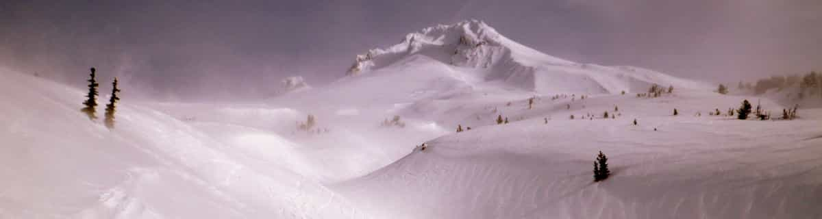
Massive Snowfall in the Alps
A huge snowfall is underway in the Alps, by far the biggest of the 24-25 season.
Please sign in with your Snow-Forecast account details below.

Kamoidake Kokusai Weather (Next 3 days): The snow forecast for Kamoidake Kokusai is: Light rain (total 8.0mm), mostly falling on Sun morning. Freeze-thaw conditions (max 11°C on Sun morning, min 0°C on Mon night). Wind will be generally light.
Kamoidake Kokusai Weather (Days 4-6): Light rain (total 7.0mm), mostly falling on Thu afternoon. Very mild (max 12°C on Thu morning, min 3°C on Fri night). Winds increasing (calm on Wed night, strong winds from the WSW by Fri morning).
| Resort | Snow Depth | Temp. (°C) | Wind (km/h) | Weather | ||
|---|---|---|---|---|---|---|
| Top Lift: | 7 | |||||
| Bottom Lift: | 7 |
Latest snow reports near Kamoidake Kokusai:

Sunday 20 | Monday 21 | Tuesday 22 | Wednesday 23 | Thursday 24 | Friday 25 | Saturday 26 | |||||||||||||||
AM | PM | night | AM | PM | night | AM | PM | night | AM | PM | night | AM | PM | night | AM | PM | night | AM | PM | night | |
rain shwrs | light rain | cloudy | light rain | light rain | some clouds | cloudy | cloudy | cloudy | cloudy | cloudy | clear | clear | rain shwrs | rain shwrs | rain shwrs | clear | rain shwrs | rain shwrs | clear | rain shwrs | |
km/h | |||||||||||||||||||||
Snow map | 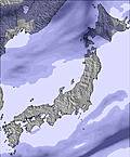 |  | 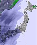 | 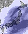 | 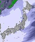 |  |  | ||||||||||||||
— | — | — | — | — | — | — | — | — | — | — | — | — | — | — | — | — | — | — | — | — | |
3 | 2.0 | — | 2.0 | 1.0 | — | — | — | — | — | — | — | — | 1.0 | 2.0 | 2.0 | — | 2.0 | 2.0 | — | 1.0 | |
max°C | 11 | 7 | 3 | 3 | 3 | 2 | 9 | 10 | 6 | 11 | 11 | 9 | 12 | 12 | 7 | 7 | 5 | 4 | 7 | 8 | 7 |
min°C | 8 | 5 | 3 | 3 | 2 | 0 | 5 | 8 | 5 | 8 | 10 | 7 | 10 | 10 | 4 | 6 | 4 | 3 | 5 | 7 | 5 |
4 | 3 | 1 | 0 | -2 | -4 | 5 | 6 | 3 | 8 | 10 | 7 | 9 | 8 | 0 | 1 | -1 | -2 | 0 | 4 | 1 | |
90 | 89 | 92 | 96 | 84 | 81 | 55 | 45 | 73 | 61 | 61 | 80 | 72 | 75 | 83 | 58 | 62 | 78 | 74 | 50 | 61 | |
2500 | 1850 | 1050 | 950 | 900 | 1450 | 2300 | 2100 | 2000 | 1950 | 2450 | 3050 | 2800 | 2300 | 1300 | 1150 | 1000 | 900 | 1000 | 1250 | 1750 | |
4:41 | — | — | 4:39 | — | — | 4:39 | — | — | 4:37 | — | — | 4:35 | — | — | 4:33 | — | — | 4:33 | — | — | |
— | 6:20 | — | — | 6:21 | — | — | 6:22 | — | — | 6:22 | — | — | 6:23 | — | — | 6:25 | — | — | 6:27 | — | |
Light rain (total 8.0mm), mostly falling on Sun morning. Freeze-thaw conditions (max 11°C on Sun morning, min 0°C on Mon night). Wind will be generally light.
Light rain (total 7.0mm), mostly falling on Thu afternoon. Very mild (max 12°C on Thu morning, min 3°C on Fri night). Winds increasing (calm on Wed night, strong winds from the WSW by Fri morning).
Latest snow reports near Kamoidake Kokusai:
| Top snow depth: | — |
|---|---|
| Bottom snow depth: | — |
| Fresh snowfall depth: | — |
| Last snowfall: | 3 Apr 2025 |
| Snow Alerts | Create Alert |
0.0 | Bluebird Powder days Fresh snow, mostly sunny, light wind. |
|---|---|
0.0 | Powder days Fresh snow, limited sun, any wind. |
0.0 | Bluebird days Average snow, mostly sunny, light wind. |
The above table gives the weather forecast for Kamoidake Kokusai at the specific elevation of 467 m. Our sophisticated weather models allow us to provide snow forecasts for the top, middle and bottom ski stations of Kamoidake Kokusai. To access the weather forecasts for the other elevations, use the tab navigation above the table. For a wider view of the weather, check out the Weather Map of Japan.
Click here to read further information on freezing levels and how we forecast our temperatures.
I spent a season doing a working holiday at Kamoidake and came to know the mountain very well and also became very fond of the staff of Kamoidake resort who are some of the nicest people I've had the pleasure of knowing! I was entertained by the mountain all season, with its wide variety of piste trails, constant fresh snowfall and as my skills improved I kept on finding new and challenging off-piste trails. Kamoidake Ski Area: Kamoidake Kokusai ski area is one of Japan's last and best kept secrets. It experiences high amounts of quality powder each season, has a good variety of well groomed trails and with a relaxed attitude taken towards off-piste skiing there are some great tree courses and side country areas to be explored and enjoyed by experts and powder hunters. Enjoy a very traditional Japanese experience at Kamoidake, and take in the spectacular country scenery of central Hokkaido from the summit, whilst being one of the only foreigners to carve up the mountain. There is something for everyone here at Kamoidake and enough to challenge any level of skier or snowboarder. The piste trails offer something for every level with wide and gradual slopes for beginners and a number of steep slopes; great for experts and speed demons. Kamoidake is used as a ski racing mountain with ski teams taking advantage of the steep and well groomed trails for training and races, however, if you visit outside of mid-December to mid-January, and it is a weekday, it would not be uncommon to find you have the mountain nearly to yourself! Going side-country and through the tree trails you will almost always be guaraunteed fresh tracks due to the high number of fresh snowfall days and also because the majority of skier on the mountain; ski racers stick to the piste trails all day. Ski Rental: There is an on-mountain ski shop with a wide range of ski gear at reasonable prices. Operating times: Ski lifts operate from 0900 to 1600. Night skiing is offered on the West slope from 1600-2000. The ski season is usually from early December until the middle of April. Price: Day tickets for adults are 3,000 Yen. There are also 1 time passes, children tickets, family tickets and night tickets available. Access: Kamoidake is located in central Hokkaido, approximately inbetween Sapporo and Asahikawa. By car it is about 1 and a half hours from Sapporo, about 1 hour from Ashikawa or also about 1 hour from Furano. The nearest city: Utashinai, is 5 mins away by car and offers the novelty of officially being the smallest city in the whole of Japan. If catching the train and coming from either Sapporo or Asahikawa stop at Sunagawa station. If coming from Furano, stop at Akabira station. A taxi will cost approximately 5000 yen from Sunagawa and 4000 yen from Akabira. It is also possible to organize a shuttle bus service with us and we will pick you up from the station. Kamoidake Resort: Kamoidake resort is located at the base of the east side of Kamoi mountain. With very reasonable prices and great views of the surrounding landscape and mountain. Stay at Kamoidake resort to have a very traditional countryside Japanese experience and to wake up on the doorstep of the ski area. Accommodation includes delicious food, a traditional style Japanese dinner, a large and diverse Japanese buffet breakfast, access to a gym and access to a large, clean, onsen, complete with a jacuzzi, cold pool and sauna. Year round activities: Kamoidake resort is open all year round. In the summer Kamoidake resort is a great place to stay and enjoy the beautiful nature and wildlife of Hokkaido. We offer hiking, horse trekking, bike riding and day trips to Furano and Biei.
Gareth Jones from Australia writes:
I spent a season doing a working holiday at Kamoidake and came to know the mountain very well and also became very fond of the staff of Kamoidake resort who are some of the nicest people I've had the pleasure of knowing! I was entertained by the mountain all season, with its wide variety of piste trails, constant fresh snowfall and as my skills improved I kept on finding new and challenging off-piste trails.
Kamoidake Ski Area:
Kamoidake Kokusai ski area is one of Japan's last and best kept secrets. It experiences high amounts of quality powder each season, has a good variety of well groomed trails and with a relaxed attitude taken towards off-piste skiing there are some great tree courses and side country areas to be explored and enjoyed by experts and powder hunters. Enjoy a very traditional Japanese experience at Kamoidake, and take in the spectacular country scenery of central Hokkaido from the summit, whilst being one of the only foreigners to carve up the mountain.
There is something for everyone here at Kamoidake and enough to challenge any level of skier or snowboarder. The piste trails offer something for every level with wide and gradual slopes for beginners and a number of steep slopes; great for experts and speed demons. Kamoidake is used as a ski racing mountain with ski teams taking advantage of the steep and well groomed trails for training and races, however, if you visit outside of mid-December to mid-January, and it is a weekday, it would not be uncommon to find you have the mountain nearly to yourself! Going side-country and through the tree trails you will almost always be guaraunteed fresh tracks due to the high number of fresh snowfall days and also because the majority of skier on the mountain; ski racers stick to the piste trails all day.
Ski Rental:
There is an on-mountain ski shop with a wide range of ski gear at reasonable prices.
Operating times:
Ski lifts operate from 0900 to 1600. Night skiing is offered on the West slope from 1600-2000. The ski season is usually from early December until the middle of April.
Price:
Day tickets for adults are 3,000 Yen. There are also 1 time passes, children tickets, family tickets and night tickets available.
Access:
Kamoidake is located in central Hokkaido, approximately inbetween Sapporo and Asahikawa. By car it is about 1 and a half hours from Sapporo, about 1 hour from Ashikawa or also about 1 hour from Furano. The nearest city: Utashinai, is 5 mins away by car and offers the novelty of officially being the smallest city in the whole of Japan.
If catching the train and coming from either Sapporo or Asahikawa stop at Sunagawa station. If coming from Furano, stop at Akabira station. A taxi will cost approximately 5000 yen from Sunagawa and 4000 yen from Akabira. It is also possible to organize a shuttle bus service with us and we will pick you up from the station.
Kamoidake Resort:
Kamoidake resort is located at the base of the east side of Kamoi mountain. With very reasonable prices and great views of the surrounding landscape and mountain. Stay at Kamoidake resort to have a very traditional countryside Japanese experience and to wake up on the doorstep of the ski area. Accommodation includes delicious food, a traditional style Japanese dinner, a large and diverse Japanese buffet breakfast, access to a gym and access to a large, clean, onsen, complete with a jacuzzi, cold pool and sauna.
Year round activities:
Kamoidake resort is open all year round. In the summer Kamoidake resort is a great place to stay and enjoy the beautiful nature and wildlife of Hokkaido. We offer hiking, horse trekking, bike riding and day trips to Furano and Biei.
The Kamoidake Kokusai skiing weather widget is available to embed on external websites free of charge. It provides a daily summary of our Kamoidake Kokusai snow forecast and current weather conditions. Simply go to the feed configuration page and follow the 3 simple steps to grab the custom html code snippet and paste it into your own site. You can choose the snow forecast elevation (summit, mid-mountain or bottom lift) and metric/imperial units for the snow forecast feed to suit your own website…. Click here to get the code.
View detailed snow forecast for Kamoidake Kokusai at:
snow-forecast.com


 Nearest