

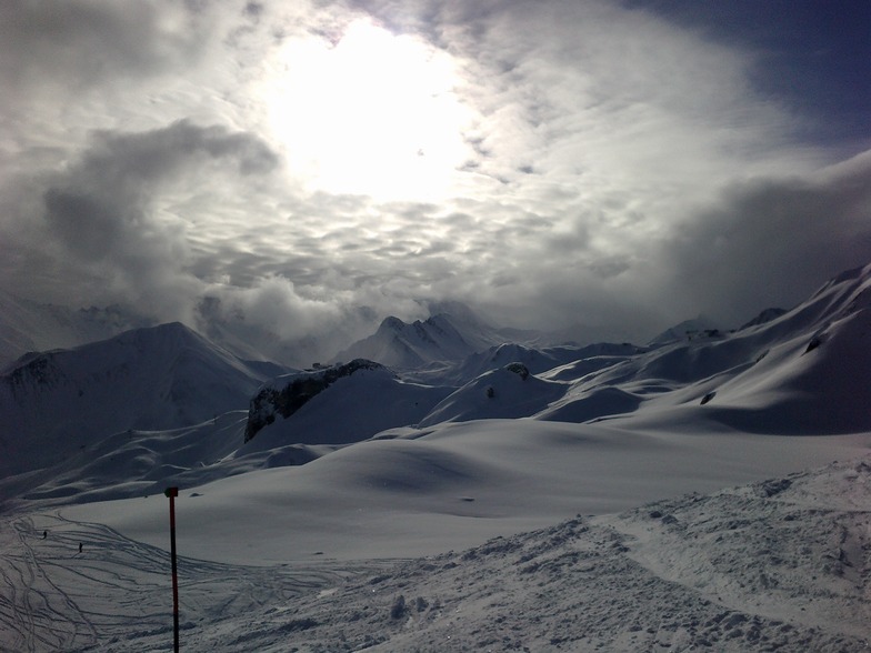
Massive Snowfall in the Alps
A huge snowfall is underway in the Alps, by far the biggest of the 24-25 season.
Please sign in with your Snow-Forecast account details below.


Ischgl Weather (Next 3 days): The snow forecast for Ischgl is: Moderate rain (total 15.0mm), heaviest on Mon afternoon. Very mild (max 12°C on Sun afternoon, min 2°C on Sat night). Wind will be generally light.
Ischgl Weather (Days 4-6): Heavy rain (total 41.0mm), heaviest during Tue night. Mild temperatures (max 7°C on Wed afternoon, min 2°C on Fri morning). Wind will be generally light.
| Resort | Snow Depth | Temp. (°C) | Wind (km/h) | Weather | ||
|---|---|---|---|---|---|---|
| Top Lift: | 1.1 m | -3 | ||||
| Middle Lift: | 3 | |||||
| Bottom Lift: | 0.9 m | 7 |
Latest snow reports near Ischgl:

Sunday 20 | Monday 21 | Tuesday 22 | Wednesday 23 | Thursday 24 | Friday 25 | ||||||||||||||
night | AM | PM | night | AM | PM | night | AM | PM | night | AM | PM | night | AM | PM | night | AM | PM | night | |
some clouds | some clouds | light rain | rain shwrs | light rain | light rain | mod. rain | some clouds | light rain | mod. rain | light rain | light rain | mod. rain | light rain | light rain | heavy rain | light rain | light rain | light rain | |
km/h | |||||||||||||||||||
Snow map |  |  |  |  |  |  |  | ||||||||||||
— | — | — | — | — | — | — | — | — | — | — | — | — | — | — | — | — | — | — | |
— | — | 1.0 | 1.0 | 1.0 | 3 | 6 | — | 3 | 8 | 4 | 2.0 | 8 | 1.0 | 2.0 | 12 | 2.0 | 2.0 | 3 | |
max°C | 7 | 9 | 12 | 7 | 9 | 10 | 7 | 8 | 10 | 6 | 6 | 7 | 6 | 5 | 6 | 5 | 4 | 4 | 3 |
min°C | 2 | 4 | 11 | 4 | 6 | 10 | 5 | 5 | 9 | 6 | 5 | 6 | 4 | 4 | 5 | 3 | 2 | 4 | 1 |
-1 | 2 | 10 | 2 | 5 | 10 | 5 | 5 | 8 | 6 | 5 | 5 | 4 | 4 | 4 | 3 | 0 | 3 | -1 | |
91 | 71 | 60 | 94 | 70 | 75 | 97 | 76 | 89 | 100 | 100 | 99 | 100 | 94 | 99 | 100 | 98 | 100 | 100 | |
2400 | 2700 | 2750 | 2250 | 2500 | 2650 | 2400 | 2400 | 2650 | 2450 | 2450 | 2500 | 2250 | 2250 | 2300 | 2050 | 2000 | 2050 | 1900 | |
— | 6:22 | — | — | 6:20 | — | — | 6:18 | — | — | 6:16 | — | — | 6:16 | — | — | 6:13 | — | — | |
— | — | — | 8:13 | — | — | 8:14 | — | — | 8:15 | — | — | 8:16 | — | — | 8:17 | — | — | 8:20 | |
Moderate rain (total 15.0mm), heaviest on Mon afternoon. Very mild (max 12°C on Sun afternoon, min 2°C on Sat night). Wind will be generally light.
Heavy rain (total 41.0mm), heaviest during Tue night. Mild temperatures (max 7°C on Wed afternoon, min 2°C on Fri morning). Wind will be generally light.
Latest snow reports near Ischgl:
| Top snow depth: | 110 cm |
|---|---|
| Bottom snow depth: | 90 cm |
| Fresh snowfall depth: | 6 cm |
| Last snowfall: | 18 Apr 2025 |
| Snow Alerts | Create Alert |
0.1 | Bluebird Powder days Fresh snow, mostly sunny, light wind. |
|---|---|
0.4 | Powder days Fresh snow, limited sun, any wind. |
0.0 | Bluebird days Average snow, mostly sunny, light wind. |
The above table gives the weather forecast for Ischgl at the specific elevation of 1378 m. Our sophisticated weather models allow us to provide snow forecasts for the top, middle and bottom ski stations of Ischgl. To access the weather forecasts for the other elevations, use the tab navigation above the table. For a wider view of the weather, check out the Weather Map of Austria.
Click here to read further information on freezing levels and how we forecast our temperatures.
Overall 4.2 Based on 47 votes and 35 reviews
Undoubtedly one of the best resorts in Europe but still relatively few Brits go there. The lifts are modern and fast. The skiing is especially good for intermediates although very advanced skiers won't be bored. Not a place for beginners. Apres-ski is very lively and great fun. I've never seen any bad behaviour, just lots of people having a really good time. There's a wide range of restaurants to suit all tastes and budgets. I've been six times and stayed in six hotels; all excellent. A great places for friends, couples and families.
Bart from United Kingdom writes:
Undoubtedly one of the best resorts in Europe but still relatively few Brits go there.
The lifts are modern and fast. The skiing is especially good for intermediates although very advanced skiers won't be bored. Not a place for beginners.
Apres-ski is very lively and great fun. I've never seen any bad behaviour, just lots of people having a really good time.
There's a wide range of restaurants to suit all tastes and budgets.
I've been six times and stayed in six hotels; all excellent.
A great places for friends, couples and families.
The Ischgl skiing weather widget is available to embed on external websites free of charge. It provides a daily summary of our Ischgl snow forecast and current weather conditions. Simply go to the feed configuration page and follow the 3 simple steps to grab the custom html code snippet and paste it into your own site. You can choose the snow forecast elevation (summit, mid-mountain or bottom lift) and metric/imperial units for the snow forecast feed to suit your own website…. Click here to get the code.
View detailed snow forecast for Ischgl at:
snow-forecast.com


 Nearest