

Massive Snowfall in the Alps
A huge snowfall is underway in the Alps, by far the biggest of the 24-25 season.
Please sign in with your Snow-Forecast account details below.


Haute Nendaz Weather (Next 3 days): The snow forecast for Haute Nendaz is: Moderate rain (total 10.0mm), heaviest on Sun morning. Freeze-thaw conditions (max 10°C on Sat afternoon, min 0°C on Fri night). Wind will be generally light.
Haute Nendaz Weather (Days 4-6): Heavy rain (total 48.0mm), heaviest during Thu morning. Very mild (max 11°C on Wed afternoon, min 2°C on Thu morning). Wind will be generally light.
| Resort | Snow Depth | Temp. (°C) | Wind (km/h) | Weather | ||
|---|---|---|---|---|---|---|
| Top Lift: | -4 | |||||
| Middle Lift: | 2 | |||||
| Bottom Lift: | 7 |
Latest snow reports near Haute Nendaz:
Drizzle reported from Sion at 339 metres elevation only 2 kms NW of Veysonnaz-Printse but it is forecast cold enough for snow at the ski area from Veysonnaz-Printse
Snowing in St-Luc. from St-Luc
Intermittent light rain reported from Sion (6720 -0) at 483 metres elevation only 2 kms N of Veysonnaz-Printse but it is forecast cold enough for snow at the ski area from Veysonnaz-Printse
Snow is falling in Verbier. from Verbier

Fri 18 | Saturday 19 | Sunday 20 | Monday 21 | Tuesday 22 | Wednesday 23 | Thursday 24 | ||||||||||||||
PM | night | AM | PM | night | AM | PM | night | AM | PM | night | AM | PM | night | AM | PM | night | AM | PM | night | |
some clouds | some clouds | some clouds | some clouds | rain shwrs | rain shwrs | rain shwrs | light rain | cloudy | light rain | light rain | mod. rain | light rain | light rain | some clouds | light rain | heavy rain | mod. rain | light rain | light snow | |
km/h | ||||||||||||||||||||
Snow map |  |  |  |  |  |  |  | |||||||||||||
— | — | — | — | — | — | — | — | — | — | — | — | — | — | — | — | — | — | — | 3 | |
— | — | — | — | 3 | 3 | 2.0 | 2.0 | — | 2.0 | 5 | 8 | 3 | 2.0 | — | 3 | 15 | 10 | 3 | 5 | |
max°C | 7 | 4 | 8 | 10 | 6 | 6 | 10 | 6 | 7 | 8 | 7 | 4 | 6 | 5 | 8 | 11 | 7 | 3 | 4 | 3 |
min°C | 6 | 0 | 3 | 9 | 2 | 4 | 9 | 3 | 4 | 8 | 5 | 4 | 5 | 4 | 5 | 10 | 3 | 2 | 4 | 1 |
6 | -3 | 0 | 7 | -1 | 4 | 8 | 3 | 4 | 8 | 5 | 4 | 5 | 4 | 5 | 10 | 3 | 1 | 3 | 1 | |
70 | 82 | 76 | 70 | 84 | 85 | 60 | 82 | 78 | 81 | 94 | 98 | 96 | 92 | 77 | 75 | 99 | 99 | 99 | 100 | |
2650 | 2950 | 2750 | 2650 | 2300 | 2350 | 2500 | 2150 | 2350 | 2500 | 2300 | 2250 | 2400 | 2350 | 2550 | 2700 | 2250 | 1950 | 2000 | 1750 | |
— | — | 6:37 | — | — | 6:35 | — | — | 6:33 | — | — | 6:33 | — | — | 6:31 | — | — | 6:28 | — | — | |
— | 8:21 | — | — | 8:22 | — | — | 8:22 | — | — | 8:24 | — | — | 8:25 | — | — | 8:27 | — | — | 8:29 | |
Moderate rain (total 10.0mm), heaviest on Sun morning. Freeze-thaw conditions (max 10°C on Sat afternoon, min 0°C on Fri night). Wind will be generally light.
Heavy rain (total 48.0mm), heaviest during Thu morning. Very mild (max 11°C on Wed afternoon, min 2°C on Thu morning). Wind will be generally light.
Latest snow reports near Haute Nendaz:
Drizzle reported from Sion at 339 metres elevation only 2 kms NW of Veysonnaz-Printse but it is forecast cold enough for snow at the ski area from Veysonnaz-Printse
Snowing in St-Luc. from St-Luc
Intermittent light rain reported from Sion (6720 -0) at 483 metres elevation only 2 kms N of Veysonnaz-Printse but it is forecast cold enough for snow at the ski area from Veysonnaz-Printse
Snow is falling in Verbier. from Verbier
| Top snow depth: | — |
|---|---|
| Bottom snow depth: | — |
| Fresh snowfall depth: | 70 cm |
| Last snowfall: | 17 Apr 2025 |
| Snow Alerts | Create Alert |
0.0 | Bluebird Powder days Fresh snow, mostly sunny, light wind. |
|---|---|
0.4 | Powder days Fresh snow, limited sun, any wind. |
0.0 | Bluebird days Average snow, mostly sunny, light wind. |
The above table gives the weather forecast for Haute Nendaz at the specific elevation of 1400 m. Our sophisticated weather models allow us to provide snow forecasts for the top, middle and bottom ski stations of Haute Nendaz. To access the weather forecasts for the other elevations, use the tab navigation above the table. For a wider view of the weather, check out the Weather Map of Switzerland.
Click here to read further information on freezing levels and how we forecast our temperatures.
Overall 4.1 Based on 12 votes and 22 reviews
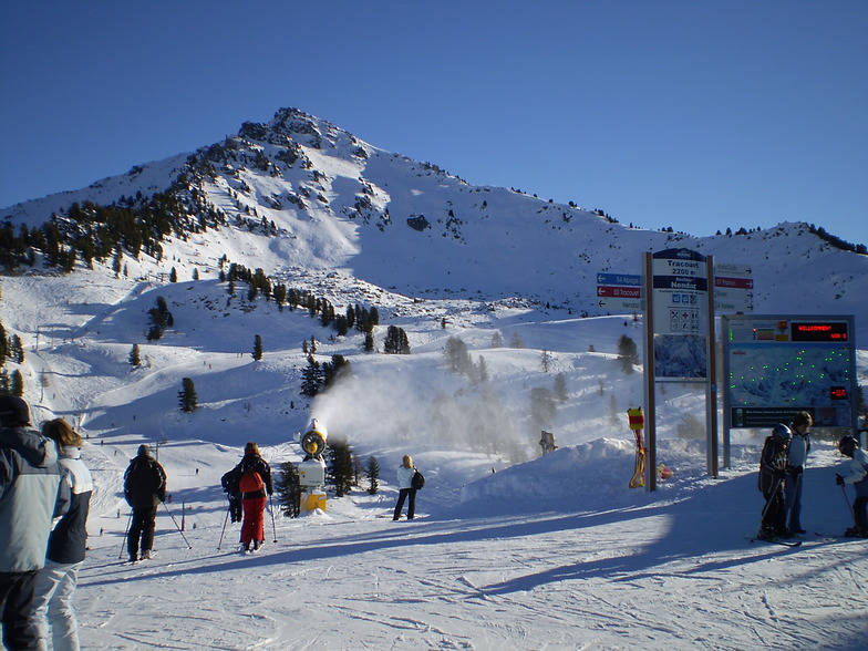
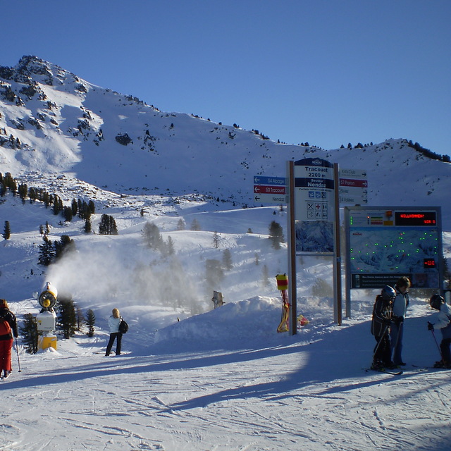
The review from Steve Feb 26 2020 is spot on. The canons have made a wonderful addition. My mates come to me here in Switzerland to ski Nendaz because of the yellows and the blacks and reds when they get tired. It's also got one of the loveliest runs ever, from Plan de Fou to Siviez. Verbier is right on the doorstep without the evening bar scene of Verbier, which for my pals at least feels a little "love island" at times. Nicer to be in a more skiers ski resort of Nendaz. Less frill, more chill.
Simon from Switzerland writes:
The review from Steve Feb 26 2020 is spot on. The canons have made a wonderful addition. My mates come to me here in Switzerland to ski Nendaz because of the yellows and the blacks and reds when they get tired. It's also got one of the loveliest runs ever, from Plan de Fou to Siviez. Verbier is right on the doorstep without the evening bar scene of Verbier, which for my pals at least feels a little "love island" at times. Nicer to be in a more skiers ski resort of Nendaz. Less frill, more chill.
The Haute Nendaz skiing weather widget is available to embed on external websites free of charge. It provides a daily summary of our Haute Nendaz snow forecast and current weather conditions. Simply go to the feed configuration page and follow the 3 simple steps to grab the custom html code snippet and paste it into your own site. You can choose the snow forecast elevation (summit, mid-mountain or bottom lift) and metric/imperial units for the snow forecast feed to suit your own website…. Click here to get the code.
View detailed snow forecast for Haute Nendaz at:
snow-forecast.com


 Nearest