

Ski Areas Ready for Star Wars Day
Several North American ski areas that are still open plan to celebrate the unofficial Star Wars Day tomorrow, May the Fourth (be with you).
Please sign in with your Snow-Forecast account details below.


Gstaad - Saanen - Rougemont Weather (Next 3 days): The snow forecast for Gstaad - Saanen - Rougemont is: A light covering of new snow, mostly falling on Wed afternoon. Becoming milder with light rain (total 2.0mm) on Thu afternoon. Freeze-thaw conditions (max 3°C on Thu afternoon, min -1°C on Mon night). Wind will be generally light.
Gstaad - Saanen - Rougemont Weather (Days 4-6): Moderate rain (total 15.0mm), heaviest on Sat afternoon. Mild temperatures (max 8°C on Sun afternoon, min 1°C on Thu night). Wind will be generally light.
| Resort | Snow Depth | Temp. (°F) | Wind (mph) | Weather | ||
|---|---|---|---|---|---|---|
| Top Lift: | 27 | |||||
| Middle Lift: | 30 | |||||
| Bottom Lift: | 36 |
Latest snow reports near Gstaad - Saanen - Rougemont:
Light rain reported from Sion at 339 metres elevation only 2 kms NW of Veysonnaz-Printse but it is forecast cold enough for snow at higher elevations in the ski area from Veysonnaz-Printse

Tuesday 6 | Wednesday 7 | Thursday 8 | Friday 9 | Saturday 10 | Sunday 11 | ||||||||||||||
night | AM | PM | night | AM | PM | night | AM | PM | night | AM | PM | night | AM | PM | night | AM | PM | night | |
cloudy | cloudy | cloudy | light snow | light snow | light snow | light snow | cloudy | light rain | light rain | rain shwrs | light rain | rain shwrs | rain shwrs | risk thun- der | rain shwrs | some clouds | risk thun- der | rain shwrs | |
mph | |||||||||||||||||||
Snow map |  |  |  |  |  |  |  | ||||||||||||
— | — | — | — | 1 | 1 | 0.4 | — | — | — | — | — | — | — | — | — | — | — | — | |
— | — | — | — | — | — | — | — | 0.08 | 0.04 | 0.04 | 0.08 | 0.04 | 0.04 | 0.2 | 0.04 | — | 0.2 | 0.1 | |
max°F | 32 | 34 | 36 | 34 | 34 | 32 | 32 | 36 | 37 | 36 | 37 | 39 | 39 | 41 | 43 | 43 | 45 | 46 | 45 |
min°F | 30 | 30 | 34 | 34 | 32 | 32 | 32 | 32 | 36 | 34 | 36 | 39 | 36 | 37 | 43 | 37 | 41 | 46 | 39 |
27 | 27 | 34 | 34 | 32 | 32 | 28 | 32 | 36 | 34 | 36 | 39 | 34 | 37 | 43 | 37 | 41 | 46 | 39 | |
97 | 88 | 95 | 98 | 99 | 99 | 90 | 80 | 90 | 87 | 80 | 83 | 83 | 68 | 73 | 76 | 62 | 65 | 83 | |
5600 | 7200 | 7200 | 7100 | 6600 | 6100 | 6100 | 7200 | 7500 | 7200 | 7500 | 8000 | 7500 | 8400 | 8700 | 8900 | 9000 | 9400 | 8700 | |
— | 6:09 | — | — | 6:07 | — | — | 6:07 | — | — | 6:05 | — | — | 6:03 | — | — | 6:03 | — | — | |
— | — | — | 8:45 | — | — | 8:46 | — | — | 8:47 | — | — | 8:50 | — | — | 8:51 | — | — | 8:52 | |
A light covering of new snow, mostly falling on Wed afternoon. Becoming milder with light rain (total 2.0mm) on Thu afternoon. Freeze-thaw conditions (max 3°C on Thu afternoon, min -1°C on Mon night). Wind will be generally light.
Moderate rain (total 15.0mm), heaviest on Sat afternoon. Mild temperatures (max 8°C on Sun afternoon, min 1°C on Thu night). Wind will be generally light.
Latest snow reports near Gstaad - Saanen - Rougemont:
Light rain reported from Sion at 339 metres elevation only 2 kms NW of Veysonnaz-Printse but it is forecast cold enough for snow at higher elevations in the ski area from Veysonnaz-Printse
| Top snow depth: | — |
|---|---|
| Bottom snow depth: | — |
| Fresh snowfall depth: | 2 in |
| Last snowfall: | 23 Apr 2025 |
| Snow Alerts | Create Alert |
0.1 | Bluebird Powder days Fresh snow, mostly sunny, light wind. |
|---|---|
0.6 | Powder days Fresh snow, limited sun, any wind. |
0.0 | Bluebird days Average snow, mostly sunny, light wind. |
The above table gives the weather forecast for Gstaad - Saanen - Rougemont at the specific elevation of 1887 m. Our sophisticated weather models allow us to provide snow forecasts for the top, middle and bottom ski stations of Gstaad - Saanen - Rougemont. To access the weather forecasts for the other elevations, use the tab navigation above the table. For a wider view of the weather, check out the Weather Map of Switzerland.
Click here to read further information on freezing levels and how we forecast our temperatures.
Overall 4.7 Based on 4 votes and 3 reviews
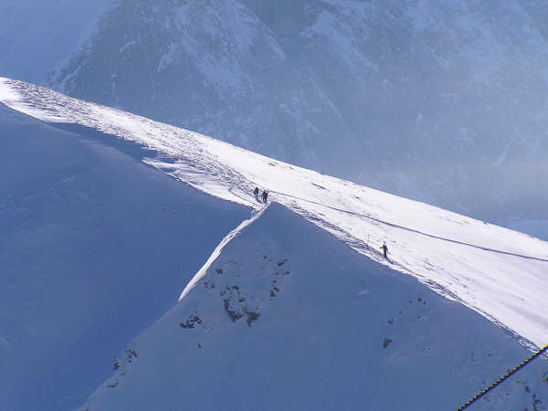
Rougemont is a chic and beautiful resort with great skiing. I would recommend it.
Rachel from United Kingdom writes:
Rougemont is a chic and beautiful resort with great skiing. I would recommend it.
Read 2 more reviews of Gstaad - Saanen - Rougemont or submit your own
The Gstaad - Saanen - Rougemont skiing weather widget is available to embed on external websites free of charge. It provides a daily summary of our Gstaad - Saanen - Rougemont snow forecast and current weather conditions. Simply go to the feed configuration page and follow the 3 simple steps to grab the custom html code snippet and paste it into your own site. You can choose the snow forecast elevation (summit, mid-mountain or bottom lift) and metric/imperial units for the snow forecast feed to suit your own website…. Click here to get the code.
View detailed snow forecast for Gstaad - Saanen - Rougemont at:
snow-forecast.com


 Nearest