

French Ski Areas Announce 2025 Summer Ski Plans
Three French ski areas have announced their opening plans in May, June and July after the winter season ends on May 4th.
Please sign in with your Snow-Forecast account details below.
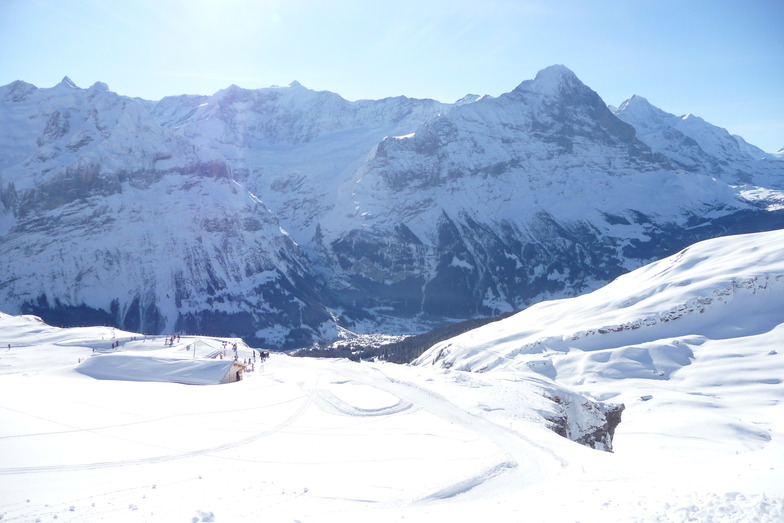

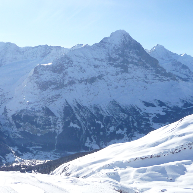
Grindelwald Weather (Next 3 days): The snow forecast for Grindelwald is: Mild with heavy rain (total 70.0mm), heaviest during Wed night. Becoming colder with a moderate fall of snow heaviest on Wed night. Mild temperatures (max 7°C on Tue afternoon, min 2°C on Wed night). Wind will be generally light.
Grindelwald Weather (Days 4-6): Mild at first with light rain (total 5.0mm) on Sat afternoon followed by colder weather and light fall of snow, heaviest on Sat night. Freeze-thaw conditions (max 6°C on Fri afternoon, min -2°C on Sat night). Wind will be generally light.
| Resort | Snow Depth | Temp. (°C) | Wind (km/h) | Weather | ||
|---|---|---|---|---|---|---|
| Top Lift: | 0.6 m | 1 | ||||
| Middle Lift: | 5 | |||||
| Bottom Lift: | 8 |
Latest snow reports near Grindelwald:
Snow crystals reported from Jungfrau Mountain at 3576 metres elevation 7 kms E of Mürren but it is probably falling as rain apart from near the top of the ski area from Mürren

Tuesday 15 | Wednesday 16 | Thursday 17 | Friday 18 | Saturday 19 | Sunday 20 | Monday 21 | |||||||||||||||
AM | PM | night | AM | PM | night | AM | PM | night | AM | PM | night | AM | PM | night | AM | PM | night | AM | PM | night | |
light rain | light rain | light rain | mod. rain | heavy rain | heavy snow | mod. rain | light rain | rain shwrs | cloudy | cloudy | cloudy | light rain | light rain | heavy snow | light snow | light snow | snow shwrs | light snow | light rain | light snow | |
km/h | |||||||||||||||||||||
Snow map |  |  |  |  |  |  |  | ||||||||||||||
— | — | — | — | — | 13 | — | — | — | — | — | — | — | — | 10 | 2.0 | 1.0 | — | — | — | 2.0 | |
2.0 | 2.0 | 5 | 10 | 17 | 19 | 10 | 3 | 2.0 | — | — | — | 1.0 | 4 | — | — | — | — | — | 1.0 | 1.0 | |
max°C | 6 | 7 | 5 | 5 | 4 | 2 | 3 | 4 | 3 | 5 | 6 | 5 | 5 | 5 | 0 | 0 | 2 | 1 | 3 | 4 | 3 |
min°C | 5 | 7 | 5 | 4 | 3 | 2 | 2 | 4 | 3 | 4 | 6 | 3 | 4 | 2 | -2 | -2 | 1 | -1 | 1 | 4 | 1 |
3 | 6 | 2 | 2 | 3 | 2 | 1 | 3 | 2 | 3 | 5 | 0 | 2 | 2 | -2 | -2 | 1 | -3 | -2 | 2 | 1 | |
84 | 79 | 83 | 89 | 99 | 98 | 99 | 99 | 90 | 94 | 90 | 79 | 90 | 99 | 92 | 90 | 92 | 75 | 83 | 88 | 98 | |
2550 | 2700 | 2500 | 2500 | 2350 | 2150 | 2400 | 2700 | 3050 | 2950 | 3000 | 2800 | 2500 | 2100 | 1400 | 1700 | 1950 | 1450 | 2200 | 2300 | 1900 | |
6:41 | — | — | 6:39 | — | — | 6:37 | — | — | 6:35 | — | — | 6:33 | — | — | 6:31 | — | — | 6:31 | — | — | |
— | — | 8:14 | — | — | 8:15 | — | — | 8:16 | — | — | 8:19 | — | — | 8:20 | — | — | 8:21 | — | — | 8:22 | |
Mild with heavy rain (total 70.0mm), heaviest during Wed night. Becoming colder with a moderate fall of snow heaviest on Wed night. Mild temperatures (max 7°C on Tue afternoon, min 2°C on Wed night). Wind will be generally light.
Mild at first with light rain (total 5.0mm) on Sat afternoon followed by colder weather and light fall of snow, heaviest on Sat night. Freeze-thaw conditions (max 6°C on Fri afternoon, min -2°C on Sat night). Wind will be generally light.
Latest snow reports near Grindelwald:
Snow crystals reported from Jungfrau Mountain at 3576 metres elevation 7 kms E of Mürren but it is probably falling as rain apart from near the top of the ski area from Mürren
| Top snow depth: | 60 cm |
|---|---|
| Bottom snow depth: | — |
| Fresh snowfall depth: | — |
| Last snowfall: | 29 Mar 2025 |
| Snow Alerts | Create Alert |
0.1 | Bluebird Powder days Fresh snow, mostly sunny, light wind. |
|---|---|
0.7 | Powder days Fresh snow, limited sun, any wind. |
0.1 | Bluebird days Average snow, mostly sunny, light wind. |


The above table gives the weather forecast for Grindelwald at the specific elevation of 1709 m. Our sophisticated weather models allow us to provide snow forecasts for the top, middle and bottom ski stations of Grindelwald. To access the weather forecasts for the other elevations, use the tab navigation above the table. For a wider view of the weather, check out the Weather Map of Switzerland.
Click here to read further information on freezing levels and how we forecast our temperatures.
Overall 4.4 Based on 27 votes and 13 reviews
Très déçu de voir le comportement de la personne qui s’est occupé du téléski Arven ce matin, commence à s’énerver et à m’insulter en allemand parce que je voulais simplement lui poser une question. Sinon Grindelwald est une excellent station ❤️
Dylann Moreno from Switzerland writes:
Très déçu de voir le comportement de la personne qui s’est occupé du téléski Arven ce matin, commence à s’énerver et à m’insulter en allemand parce que je voulais simplement lui poser une question.
Sinon Grindelwald est une excellent station ❤️
The Grindelwald skiing weather widget is available to embed on external websites free of charge. It provides a daily summary of our Grindelwald snow forecast and current weather conditions. Simply go to the feed configuration page and follow the 3 simple steps to grab the custom html code snippet and paste it into your own site. You can choose the snow forecast elevation (summit, mid-mountain or bottom lift) and metric/imperial units for the snow forecast feed to suit your own website…. Click here to get the code.
View detailed snow forecast for Grindelwald at:
snow-forecast.com


 Nearest