Fuentes de Invierno snow
Ski Spain

Fuentes de Invierno Snow Forecast

Weather Forecast for Fuentes de Invierno at 1501 m
Issued: 1 pm  16 Apr 2025 (local time)

Popular Fuentes de Invierno Pages

New snow in Fuentes de Invierno

4.0cm1.6in
Wed 16th (PM)
The snow forecast for Fuentes de Invierno is: Moderate rain (total 13.0mm), heaviest on Fri afternoon giving way to a moderate fall of snow, heaviest on Fri night. Freeze-thaw conditions (max 7°C on Thu afternoon, min -4°C on Sat morning). Winds increasing (calm on Wed night, fresh winds from the S by Fri morning).

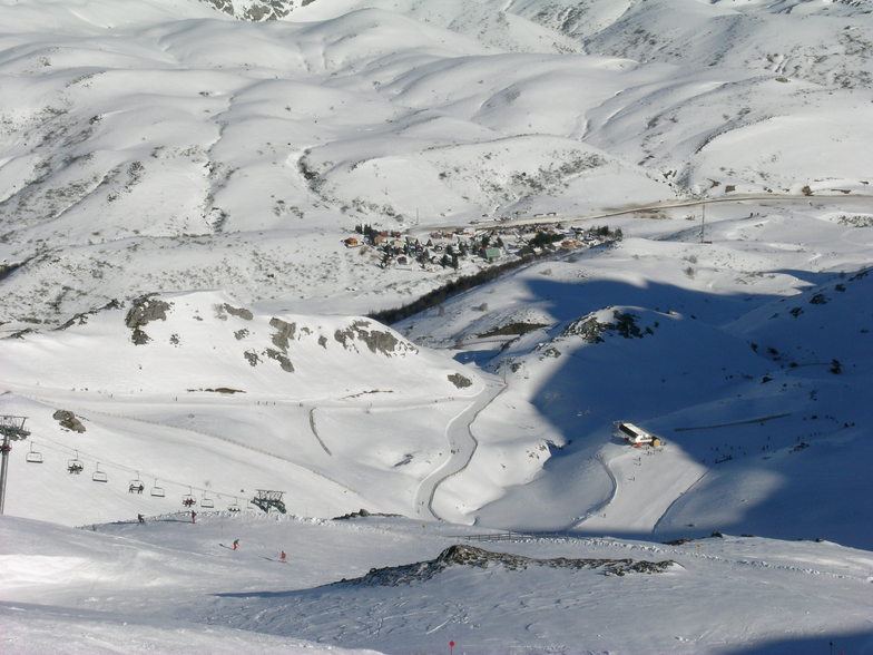
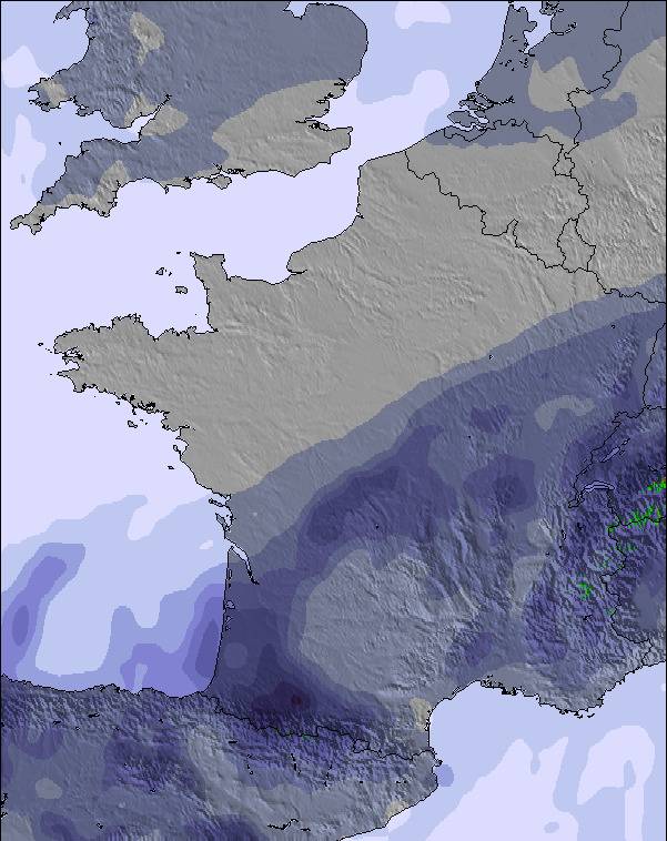
Fuentes de Invierno Weather (Next 3 days): The snow forecast for Fuentes de Invierno is: Moderate rain (total 13.0mm), heaviest on Fri afternoon giving way to a moderate fall of snow, heaviest on Fri night. Freeze-thaw conditions (max 7°C on Thu afternoon, min -4°C on Sat morning). Winds increasing (calm on Wed night, fresh winds from the S by Fri morning).

Fuentes de Invierno Weather (Days 4-6): A light fall of snow, heaviest on Sat night. Turning milder with light rain (total 8.0mm) on Sun night. Freeze-thaw conditions (max 5°C on Tue morning, min -1°C on Sat night). Wind will be generally light.


Fuentes de Invierno Live Weather

ResortSnow DepthTemp. (°C)Wind (km/h)Weather
Top Lift: 0.0m
-3
30
snow showers
Middle Lift: 
-1
25
snow showers
Bottom Lift: 0.0m
1
20
snow showers
Powered by Snow-Forecast.comSnow-Forecast.com
6 Day Forecast
Issued: 1 pm 16 Apr 2025 / Updates in ::
Change Forecast Height
Choose Forecast
Last 6 daysScroll left for last 6 daysNow
Wed
16
Thursday
17
Friday
18
Saturday
19
Sunday
20
Monday
21
Tuesday
22
PM
night
AM
PM
night
AM
PM
night
AM
PM
night
AM
PM
night
AM
PM
night
AM
PM
night
light snow
snow showers
cloud
cloud
cloud
light rain
mod rain
snow showers
clear
light snow
mod snow
light snow
light snow
light rain
snow showers
rain showers
cloud
part cloud
light rain
part cloud
light snow
snow shwrs
cloudy
cloudy
cloudy
light rain
mod. rain
snow shwrs
clear
light snow
mod. snow
light snow
light snow
light rain
snow shwrs
rain shwrs
cloudy
some clouds
light rain
some clouds
 km/h
20
WNW
10
WNW
5
SW
10
SW
20
S
30
S
25
SSW
10
NW
10
SW
10
SW
10
N
15
NW
10
NW
10
WSW
10
NW
5
NNW
0
N
5
NW
5
NNW
5
SSW
Snow map
 cm 
3
2.0
7
1.0
8
2.0
 mm 
2.0
10
1.0
5
1.0
2.0
1.0
max°C
1
-1
2
7
6
4
5
5
0
1
-1
-1
2
2
2
4
3
5
8
7
min°C
0
-3
-2
3
4
4
4
-1
-4
1
-1
-1
0
1
1
3
1
1
8
5
chill°C 
-3
-5
-4
0
0
-1
-1
-4
-7
-5
-4
-6
-3
1
-3
1
-1
1
8
5
Humid% 
86
85
63
78
92
95
87
98
68
92
99
99
91
95
92
79
91
80
69
68
Freezing level (m
1600
1350
2000
2500
2450
2350
2200
1250
1500
1600
1300
1350
1900
1900
1850
2350
2050
2100
2450
2800
topliftbotliftSea lvl1000m2000m3000m4000m5000m
-3-3-12422-1-4-3-4-3-110211451-2055452-21-1-112242386
Sunrise
7:37
7:35
7:33
7:31
7:31
7:28
Sunset
9:04
9:05
9:06
9:07
9:08
9:09
9:10
Popular Fuentes de Invierno Pages

Snow Radar

Latest snow reports near Fuentes de Invierno:

No recent snow reports

No recent snow reports

Fuentes de Invierno Snow Conditions

Top snow depth:0cm
Bottom snow depth:0cm
Fresh snowfall depth:8cm
Last snowfall:15 Apr 2025
Snow AlertsCreate Alert
Other resorts in Spain are reporting: powder (0) / good piste (0)

Snow-Forecast Partner Offers

Snow History

Week 3 of April has on average:
0.1
Bluebird Powder days
Fresh snow, mostly sunny, light wind.
0.3
Powder days
Fresh snow, limited sun, any wind.
0.0
Bluebird days
Average snow, mostly sunny, light wind.


Snow-Forecast Partner Offers