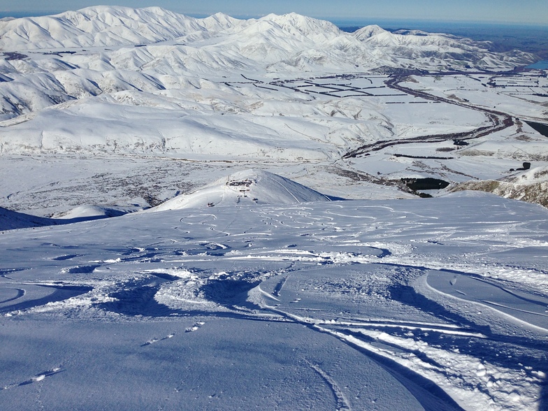
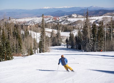
Fox Peak snow
Ski New Zealand

Fox Peak Snow Forecast

Weather Forecast for Fox Peak at 1851 m
Issued: 6 pm  02 Apr 2025 (local time)

New snow in Fox Peak

3.0cm1.2in
Mon 7th (NGT)
The snow forecast for Fox Peak is: Heavy rain (total 34.0mm), heaviest during Thu afternoon. Mild temperatures (max 8°C on Thu night, min 3°C on Fri night). Winds decreasing (fresh winds from the NW on Thu night, light winds from the NW by Sat morning).

Fox Peak Weather (Next 3 days): The snow forecast for Fox Peak is: Heavy rain (total 34.0mm), heaviest during Thu afternoon. Mild temperatures (max 8°C on Thu night, min 3°C on Fri night). Winds decreasing (fresh winds from the NW on Thu night, light winds from the NW by Sat morning).

Fox Peak Weather (Days 4-6): Mild at first with light rain (total 9.0mm) on Mon night followed by colder weather and light fall of snow, heaviest on Tue morning. Freeze-thaw conditions (max 5°C on Sat afternoon, min -3°C on Tue morning). Winds increasing (calm on Sun afternoon, strong winds from the NW by Mon night).


Fox Peak Live Weather

ResortSnow DepthTemp. (°C)Wind (km/h)Weather
Top Lift: 
5
15
light rain
Middle Lift: 
6
10
light rain
Bottom Lift: 
8
10
light rain
Powered by Snow-Forecast.comSnow-Forecast.com
6 Day Forecast
Issued: 6 pm 02 Apr 2025 / Updates in ::
Change Forecast Height
Choose Forecast
Last 6 daysScroll left for last 6 daysNow
Wed
2
Thursday
3
Friday
4
Saturday
5
Sunday
6
Monday
7
Tuesday
8
PM
night
AM
PM
night
AM
PM
night
AM
PM
night
AM
PM
night
AM
PM
night
AM
PM
night
light rain
mod rain
mod rain
heavy rain
rain showers
part cloud
part cloud
rain showers
clear
part cloud
cloud
part cloud
cloud
part cloud
part cloud
rain showers
light snow
mod snow
light snow
snow showers
light rain
mod. rain
mod. rain
heavy rain
rain shwrs
some clouds
some clouds
rain shwrs
clear
some clouds
cloudy
some clouds
cloudy
some clouds
some clouds
rain shwrs
light snow
mod. snow
light snow
snow shwrs
 km/h
10
NNE
25
N
30
NNW
25
N
30
NW
35
NW
30
WNW
20
WNW
10
W
10
NW
10
NW
5
NW
5
SW
10
NNW
10
WNW
20
NW
40
NW
15
SW
15
SW
15
WSW
Snow map
 cm 
3
9
2.0
 mm 
2.0
6
9
14
2.0
1.0
1.0
8
max°C
5
7
7
7
8
8
7
5
5
5
3
5
5
4
5
5
4
-3
-2
-1
min°C
4
5
7
7
8
8
6
3
3
4
3
4
5
3
4
3
-1
-3
-3
-3
chill°C 
1
2
3
3
4
4
2
-1
0
1
0
3
5
0
2
-3
-5
-8
-8
-7
Humid% 
99
98
89
95
78
69
69
74
60
56
44
66
73
79
72
67
85
97
82
70
Freezing level (m
3100
3150
3250
3200
3200
3050
2850
2600
2600
2650
2750
2500
2550
2500
2550
2500
2400
1450
1550
1300
topliftbotliftSea lvl1000m2000m3000m4000m5000m
56778874453554542-3-3-289111111121279959107995230
Sunrise
7:54
7:56
7:56
6:58
7:58
8:00
Sunset
7:25
7:23
7:22
7:21
6:19
7:16
7:15

Snow Radar

Latest snow reports near Fox Peak:

No recent snow reports

No recent snow reports

Fox Peak Snow Conditions

Top snow depth:
Bottom snow depth:
Fresh snowfall depth:
Last snowfall:18 Mar 2025
Snow AlertsCreate Alert
Other resorts in New Zealand are reporting: powder (0) / good piste (0)

Snow-Forecast Partner Offers

Snow History

Week 1 of April has on average:
0.1
Bluebird Powder days
Fresh snow, mostly sunny, light wind.
0.2
Powder days
Fresh snow, limited sun, any wind.
0.0
Bluebird days
Average snow, mostly sunny, light wind.

Fox Peak Resort Webcam

Live Snow webcam for Fox Peak
Most recent Fox Peak webcam image
Webcam courtesy of Fox Peak webcam
  • todayFox Peak webcam at lunchtime today
  • 2pm yesterdayFox Peak webcam at 2pm yesterday
  • 2 days agoFox Peak webcam 2 days ago
  • 3 days agoFox Peak webcam 3 days ago
  • 4 days agoFox Peak webcam 4 days ago