

Snowmaking in Saudi Arabia As Ski Resort Construction Gathers Pace
Test snowmaking has taken place at Saudi Arabia’s new Trojena ski resort as the development continues to take shape.
Please sign in with your Snow-Forecast account details below.

Flachau-Reitdorf Weather (Next 3 days): The snow forecast for Flachau-Reitdorf is: A light covering of new snow, mostly falling on Wed night. Becoming milder with moderate rain (total 11.0mm) heaviest on Fri morning. Freeze-thaw conditions (max 5°C on Wed morning, min 0°C on Thu night). Wind will be generally light.
Flachau-Reitdorf Weather (Days 4-6): Mild with light rain (total 2.0mm) on Sat morning Becoming colder with a light covering of snow, mostly falling on Sun morning. Freeze-thaw conditions (max 4°C on Sat morning, min -2°C on Sun night). Wind will be generally light.
| Resort | Snow Depth | Temp. (°C) | Wind (km/h) | Weather | ||
|---|---|---|---|---|---|---|
| Top Lift: | 1.3 m | -1 | ||||
| Middle Lift: | 2 | |||||
| Bottom Lift: | 0.8 m | 4 |
Latest snow reports near Flachau-Reitdorf:

Wednesday 12 | Thursday 13 | Friday 14 | Saturday 15 | Sunday 16 | Monday 17 | ||||||||||||||
night | AM | PM | night | AM | PM | night | AM | PM | night | AM | PM | night | AM | PM | night | AM | PM | night | |
light snow | light rain | cloudy | light snow | light snow | light snow | snow shwrs | mod. rain | light snow | light snow | light snow | light rain | light snow | light snow | light snow | light snow | cloudy | light snow | some clouds | |
km/h | |||||||||||||||||||
Snow map |  |  |  |  |  |  |  | ||||||||||||
— | — | — | 2.0 | 2.0 | 1.0 | — | — | — | 2.0 | — | — | — | 4 | 2.0 | 1.0 | — | — | — | |
— | 2.0 | — | 1.0 | — | — | — | 7 | 1.0 | — | 1.0 | 1.0 | — | — | — | — | — | — | — | |
max°C | 2 | 5 | 5 | 2 | 2 | 2 | 1 | 2 | 2 | 1 | 4 | 4 | 2 | 1 | 1 | 0 | 2 | 2 | -2 |
min°C | 2 | 4 | 2 | 1 | 1 | 1 | 0 | 2 | 1 | 0 | 2 | 3 | 0 | 1 | 0 | -2 | 0 | -2 | -4 |
0 | 2 | 0 | 1 | 1 | 1 | 0 | 1 | 1 | 0 | 2 | 1 | 0 | 1 | 0 | -2 | 0 | -2 | -4 | |
85 | 86 | 75 | 96 | 100 | 98 | 95 | 95 | 97 | 99 | 99 | 87 | 94 | 99 | 99 | 98 | 85 | 86 | 92 | |
1700 | 2000 | 2150 | 1750 | 1600 | 1650 | 1300 | 1750 | 1800 | 1450 | 1700 | 2100 | 1650 | 1600 | 1550 | 1200 | 1400 | 1650 | 900 | |
— | 6:26 | — | — | 6:24 | — | — | 6:22 | — | — | 6:20 | — | — | 6:18 | — | — | 6:16 | — | — | |
— | — | 6:07 | — | — | 6:07 | — | — | 6:08 | — | — | 6:10 | — | — | 6:12 | — | — | 6:14 | — | |
A light covering of new snow, mostly falling on Wed night. Becoming milder with moderate rain (total 11.0mm) heaviest on Fri morning. Freeze-thaw conditions (max 5°C on Wed morning, min 0°C on Thu night). Wind will be generally light.
Mild with light rain (total 2.0mm) on Sat morning Becoming colder with a light covering of snow, mostly falling on Sun morning. Freeze-thaw conditions (max 4°C on Sat morning, min -2°C on Sun night). Wind will be generally light.
Latest snow reports near Flachau-Reitdorf:
| Top snow depth: | 130 cm |
|---|---|
| Bottom snow depth: | 80 cm |
| Fresh snowfall depth: | — |
| Last snowfall: | 10 Mar 2025 |
| Snow Alerts | Create Alert |
0.2 | Bluebird Powder days Fresh snow, mostly sunny, light wind. |
|---|---|
1.2 | Powder days Fresh snow, limited sun, any wind. |
0.3 | Bluebird days Average snow, mostly sunny, light wind. |
The above table gives the weather forecast for Flachau-Reitdorf at the specific elevation of 1372 m. Our sophisticated weather models allow us to provide snow forecasts for the top, middle and bottom ski stations of Flachau-Reitdorf. To access the weather forecasts for the other elevations, use the tab navigation above the table. For a wider view of the weather, check out the Weather Map of Austria.
Click here to read further information on freezing levels and how we forecast our temperatures.
Overall 4.6 Based on 6 votes and 9 reviews
Update to my previous review. The Snowspace Flachau completed the link to Kleinarl last summer. This new Panoramabahn increases the pistes to over 210km spread across the villages of Alpendorf, Wagrain, Flacahu, Kleinarl and Zauchensee. New uplifts in Wagrain have increased capacity in the middle of Snowspace so it is quick and easy to get on the mountains.
Simon from Austria writes:
Update to my previous review. The Snowspace Flachau completed the link to Kleinarl last summer. This new Panoramabahn increases the pistes to over 210km spread across the villages of Alpendorf, Wagrain, Flacahu, Kleinarl and Zauchensee. New uplifts in Wagrain have increased capacity in the middle of Snowspace so it is quick and easy to get on the mountains.
The Flachau-Reitdorf skiing weather widget is available to embed on external websites free of charge. It provides a daily summary of our Flachau-Reitdorf snow forecast and current weather conditions. Simply go to the feed configuration page and follow the 3 simple steps to grab the custom html code snippet and paste it into your own site. You can choose the snow forecast elevation (summit, mid-mountain or bottom lift) and metric/imperial units for the snow forecast feed to suit your own website…. Click here to get the code.
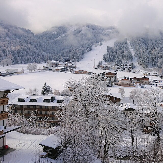
View detailed snow forecast for Flachau-Reitdorf at:
snow-forecast.com


 Nearest