
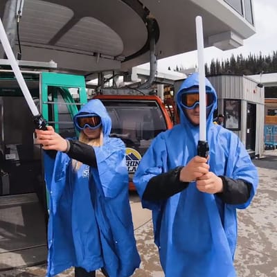
Ski Areas Ready for Star Wars Day
Several North American ski areas that are still open plan to celebrate the unofficial Star Wars Day tomorrow, May the Fourth (be with you).
Please sign in with your Snow-Forecast account details below.

Edelweiss Valley Weather (Next 3 days): The snow forecast for Edelweiss Valley is: Light rain (total 3.0mm), mostly falling on Mon night. Very mild (max 17°C on Sun afternoon, min 5°C on Sat night). Wind will be generally light.
Edelweiss Valley Weather (Days 4-6): Heavy rain (total 29.0mm), heaviest during Wed afternoon. Very mild (max 14°C on Tue afternoon, min 2°C on Thu night). Wind will be generally light.
| Resort | Snow Depth | Temp. (°F) | Wind (mph) | Weather | ||
|---|---|---|---|---|---|---|
| Top Lift: | 46 | |||||
| Bottom Lift: | 46 |
Latest snow reports near Edelweiss Valley:

Saturday 3 | Sunday 4 | Monday 5 | Tuesday 6 | Wednesday 7 | Thursday 8 | Friday 9 | |||||||||||||||
AM | PM | night | AM | PM | night | AM | PM | night | AM | PM | night | AM | PM | night | AM | PM | night | AM | PM | night | |
cloudy | cloudy | cloudy | some clouds | cloudy | cloudy | cloudy | cloudy | light rain | light rain | light rain | light rain | light rain | mod. rain | mod. rain | light rain | light rain | light rain | cloudy | cloudy | some clouds | |
mph | |||||||||||||||||||||
Snow map |  |  |  |  |  |  |  | ||||||||||||||
— | — | — | — | — | — | — | — | — | — | — | — | — | — | — | — | — | — | — | — | — | |
— | — | — | — | — | — | — | — | 0.1 | 0.04 | 0.08 | 0.1 | 0.1 | 0.2 | 0.3 | 0.08 | 0.08 | 0.08 | — | — | — | |
max°F | 50 | 57 | 50 | 57 | 63 | 52 | 52 | 57 | 55 | 54 | 57 | 57 | 55 | 57 | 50 | 41 | 41 | 37 | 41 | 45 | 43 |
min°F | 45 | 57 | 41 | 46 | 61 | 45 | 46 | 50 | 52 | 52 | 55 | 54 | 54 | 57 | 37 | 37 | 41 | 36 | 37 | 45 | 36 |
43 | 57 | 39 | 46 | 61 | 39 | 41 | 46 | 50 | 50 | 54 | 54 | 54 | 57 | 32 | 32 | 36 | 30 | 32 | 43 | 36 | |
64 | 51 | 83 | 45 | 41 | 49 | 58 | 72 | 98 | 95 | 96 | 98 | 97 | 90 | 94 | 88 | 91 | 96 | 84 | 87 | 96 | |
6900 | 7100 | 7900 | 9200 | 10300 | 11000 | 10000 | 10200 | 10000 | 9500 | 10000 | 9200 | 8400 | 8400 | 4900 | 2500 | 2800 | 2100 | 3800 | 4100 | 6100 | |
5:41 | — | — | 5:39 | — | — | 5:37 | — | — | 5:37 | — | — | 5:35 | — | — | 5:33 | — | — | 5:33 | — | — | |
— | — | 8:06 | — | — | 8:07 | — | — | 8:07 | — | — | 8:09 | — | — | 8:10 | — | — | 8:12 | — | — | 8:13 | |
Light rain (total 3.0mm), mostly falling on Mon night. Very mild (max 17°C on Sun afternoon, min 5°C on Sat night). Wind will be generally light.
Heavy rain (total 29.0mm), heaviest during Wed afternoon. Very mild (max 14°C on Tue afternoon, min 2°C on Thu night). Wind will be generally light.
Latest snow reports near Edelweiss Valley:
| Top snow depth: | — |
|---|---|
| Bottom snow depth: | — |
| Fresh snowfall depth: | — |
| Last snowfall: | 26 Apr 2025 |
| Snow Alerts | Create Alert |
0.0 | Bluebird Powder days Fresh snow, mostly sunny, light wind. |
|---|---|
0.0 | Powder days Fresh snow, limited sun, any wind. |
0.1 | Bluebird days Average snow, mostly sunny, light wind. |
The above table gives the weather forecast for Edelweiss Valley at the specific elevation of 150 m. Our sophisticated weather models allow us to provide snow forecasts for the top, middle and bottom ski stations of Edelweiss Valley. To access the weather forecasts for the other elevations, use the tab navigation above the table. For a wider view of the weather, check out the Weather Map of Canada.
Click here to read further information on freezing levels and how we forecast our temperatures.
Overall 4.1 Based on 2 votes and 1 review
Take some tea and hit the Zoomer full speed ahead...summertime events not to be missed include Le Grand Splash.. safety meetings at the top, full speed on the way down...watch out for the punter zone (losers only)... vive le quebecois
Tim Collins from Canada writes:
Take some tea and hit the Zoomer full speed ahead...summertime events not to be missed include Le Grand Splash.. safety meetings at the top, full speed on the way down...watch out for the punter zone (losers only)... vive le quebecois
The Edelweiss Valley skiing weather widget is available to embed on external websites free of charge. It provides a daily summary of our Edelweiss Valley snow forecast and current weather conditions. Simply go to the feed configuration page and follow the 3 simple steps to grab the custom html code snippet and paste it into your own site. You can choose the snow forecast elevation (summit, mid-mountain or bottom lift) and metric/imperial units for the snow forecast feed to suit your own website…. Click here to get the code.
View detailed snow forecast for Edelweiss Valley at:
snow-forecast.com


 Nearest