
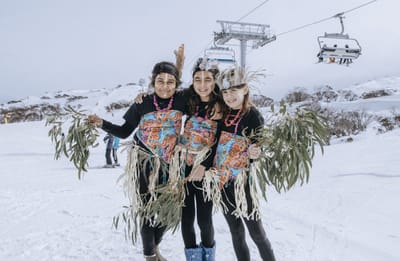
New Highest Lift in Australia Officially Open
Australia’s Perisher ski area, the country’s largest, has celebrated the official opening of the Mt Perisher 6 Chairlift, a six-seater, high-speed detachable chairlift with an opening ceremony.
By using Snow-Forecast, you agree to our Terms & Services.
Don't have an account? Join now
Alternatively, you can now use your Outside account to sign in to any brand in the Outside digital ecosystem, including Snow-Forecast, Surf-Forecast, and Mountain-Forecast.


Kurodake Weather (Next 3 days): The snow forecast for Kurodake is: Moderate rain (total 19.0mm), heaviest on Tue afternoon. Warm (max 21°C on Thu morning, min 18°C on Tue night). Wind will be generally light.
Kurodake Weather (Days 4-6): Moderate rain (total 10.0mm), heaviest on Sat night. Warm (max 22°C on Fri morning, min 18°C on Sat night). Wind will be generally light.
| Resort | Snow Depth | Temp. (°C) | Wind (km/h) | Weather | ||
|---|---|---|---|---|---|---|
| Top Lift: | 0.0 m | 16 | ||||
| Middle Lift: | 19 | |||||
| Bottom Lift: | 0.0 m | 22 |
Latest snow reports near Kurodake:

Tuesday 29 | Wednesday 30 | Thursday 31 | Friday 1 | Saturday 2 | Sunday 3 | Monday 4 | |||||||||||||||
AM | PM | night | AM | PM | night | AM | PM | night | AM | PM | night | AM | PM | night | AM | PM | night | AM | PM | night | |
risk thun- der | risk thun- der | cloudy | light rain | rain shwrs | light rain | light rain | risk thun- der | some clouds | some clouds | risk thun- der | light rain | risk thun- der | risk thun- der | rain shwrs | some clouds | some clouds | some clouds | rain shwrs | risk thun- der | rain shwrs | |
km/h | |||||||||||||||||||||
Snow map |  |  |  |  |  |  |  | ||||||||||||||
— | — | — | — | — | — | — | — | — | — | — | — | — | — | — | — | — | — | — | — | — | |
3 | 6 | — | 2 | 3 | 2 | 1 | 2 | — | — | 2 | 2 | 2 | 2 | 2 | — | — | — | 3 | 11 | 8 | |
max°C | 19 | 19 | 18 | 20 | 20 | 19 | 21 | 20 | 19 | 22 | 21 | 19 | 20 | 21 | 19 | 22 | 21 | 19 | 20 | 19 | 18 |
min°C | 19 | 19 | 18 | 19 | 19 | 18 | 19 | 20 | 19 | 21 | 20 | 19 | 20 | 20 | 18 | 20 | 19 | 18 | 20 | 19 | 16 |
19 | 19 | 18 | 19 | 19 | 18 | 19 | 20 | 19 | 21 | 20 | 19 | 20 | 20 | 18 | 20 | 19 | 18 | 20 | 19 | 16 | |
91 | 95 | 96 | 92 | 92 | 97 | 92 | 90 | 83 | 76 | 80 | 94 | 69 | 80 | 84 | 72 | 70 | 82 | 80 | 91 | 92 | |
4650 | 4750 | 4950 | 5000 | 5100 | 5300 | 5050 | 5000 | 4850 | 4900 | 4800 | 4850 | 4600 | 4650 | 4700 | 4750 | 4700 | 4600 | 4350 | 4500 | 4300 | |
4:13 | — | — | 4:13 | — | — | 4:15 | — | — | 4:16 | — | — | 4:16 | — | — | 4:18 | — | — | 4:18 | — | — | |
— | 6:54 | — | — | 6:53 | — | — | 6:52 | — | — | 6:52 | — | — | 6:51 | — | — | 6:49 | — | — | 6:47 | — | |
Moderate rain (total 19.0mm), heaviest on Tue afternoon. Warm (max 21°C on Thu morning, min 18°C on Tue night). Wind will be generally light.
Moderate rain (total 10.0mm), heaviest on Sat night. Warm (max 22°C on Fri morning, min 18°C on Sat night). Wind will be generally light.
Latest snow reports near Kurodake:
| Top snow depth: | 0 cm |
|---|---|
| Bottom snow depth: | 0 cm |
| Fresh snowfall depth: | — |
| Last snowfall: | 4 Jun 2025 |
| Snow Alerts | Create Alert |
0.0 | Bluebird Powder days Fresh snow, mostly sunny, light wind. |
|---|---|
0.0 | Powder days Fresh snow, limited sun, any wind. |
0.0 | Bluebird days Average snow, mostly sunny, light wind. |
The above table gives the weather forecast for Kurodake at the specific elevation of 1110 m. Our sophisticated weather models allow us to provide snow forecasts for the top, middle and bottom ski stations of Kurodake. To access the weather forecasts for the other elevations, use the tab navigation above the table. For a wider view of the weather, check out the Weather Map of Japan.
Click here to read further information on freezing levels and how we forecast our temperatures.
The Kurodake skiing weather widget is available to embed on external websites free of charge. It provides a daily summary of our Kurodake snow forecast and current weather conditions. Simply go to the feed configuration page and follow the 3 simple steps to grab the custom html code snippet and paste it into your own site. You can choose the snow forecast elevation (summit, mid-mountain or bottom lift) and metric/imperial units for the snow forecast feed to suit your own website…. Click here to get the code.
View detailed snow forecast for Kurodake at:
snow-forecast.com


 Nearest