

French Ski Areas Announce 2025 Summer Ski Plans
Three French ski areas have announced their opening plans in May, June and July after the winter season ends on May 4th.
Please sign in with your Snow-Forecast account details below.


Cortina Weather (Next 3 days): The snow forecast for Cortina is: A dusting of snow. Milder later with heavy rain (total 31.0mm) on Thu afternoon. Temperatures will be slightly above freezing (max 4°C on Wed afternoon, min 1°C on Mon night). Wind will be generally light.
Cortina Weather (Days 4-6): Mild with heavy rain (total 23.0mm), heaviest during Thu night. Becoming colder with a moderate fall of snow heaviest on Thu night. Freeze-thaw conditions (max 4°C on Fri afternoon, min 0°C on Fri night). Wind will be generally light.
| Resort | Snow Depth | Temp. (°C) | Wind (km/h) | Weather | ||
|---|---|---|---|---|---|---|
| Top Lift: | 0.9 m | -3 | ||||
| Middle Lift: | 2 | |||||
| Bottom Lift: | 0.1 m | 6 |
Latest snow reports near Cortina:
Light rain reported from Rolle Pass Airport at 2083 metres elevation only 2 kms S of Passo Rolle but it is forecast cold enough for snow at higher elevations in the ski area from Passo Rolle
Continuous light rain reported from PassoRolle at 2006 metres elevation SE of Passo Rolle but it is forecast cold enough for snow at higher elevations in the ski area from Passo Rolle

Tuesday 15 | Wednesday 16 | Thursday 17 | Friday 18 | Saturday 19 | Sunday 20 | ||||||||||||||
night | AM | PM | night | AM | PM | night | AM | PM | night | AM | PM | night | AM | PM | night | AM | PM | night | |
light snow | light snow | light rain | light rain | light rain | light rain | light rain | mod. rain | mod. rain | mod. snow | light snow | light rain | rain shwrs | clear | light rain | light snow | light snow | light snow | light snow | |
km/h | |||||||||||||||||||
Snow map |  |  |  |  |  |  |  | ||||||||||||
2.0 | — | — | — | — | — | — | — | — | 6 | 4 | — | — | — | — | — | 1.0 | 5 | 1.0 | |
1.0 | 1.0 | 5 | 2.0 | 1.0 | 2.0 | 3 | 6 | 10 | 19 | — | 2.0 | 1.0 | — | 1.0 | — | — | — | — | |
max°C | 2 | 2 | 3 | 3 | 3 | 4 | 3 | 4 | 3 | 2 | 2 | 4 | 2 | 4 | 4 | 2 | 1 | 1 | 0 |
min°C | 1 | 2 | 3 | 2 | 2 | 4 | 3 | 3 | 3 | 1 | 1 | 3 | 0 | 2 | 3 | 1 | 1 | 0 | -1 |
-2 | 0 | 0 | 0 | -1 | 1 | 0 | 0 | 0 | 1 | 1 | 2 | 0 | 1 | 2 | -1 | -2 | -2 | -1 | |
98 | 99 | 99 | 81 | 93 | 85 | 97 | 95 | 97 | 98 | 89 | 89 | 86 | 67 | 92 | 96 | 98 | 99 | 86 | |
2350 | 2600 | 2650 | 2600 | 2550 | 2700 | 2650 | 2750 | 2700 | 2550 | 2400 | 2500 | 2350 | 2600 | 2550 | 2350 | 2300 | 2150 | 2000 | |
— | 6:24 | — | — | 6:22 | — | — | 6:22 | — | — | 6:20 | — | — | 6:18 | — | — | 6:16 | — | — | |
— | — | 7:58 | — | — | 7:59 | — | — | — | 8:00 | — | — | 8:01 | — | — | 8:02 | — | — | 8:05 | |
A dusting of snow. Milder later with heavy rain (total 31.0mm) on Thu afternoon. Temperatures will be slightly above freezing (max 4°C on Wed afternoon, min 1°C on Mon night). Wind will be generally light.
Mild with heavy rain (total 23.0mm), heaviest during Thu night. Becoming colder with a moderate fall of snow heaviest on Thu night. Freeze-thaw conditions (max 4°C on Fri afternoon, min 0°C on Fri night). Wind will be generally light.
Latest snow reports near Cortina:
Light rain reported from Rolle Pass Airport at 2083 metres elevation only 2 kms S of Passo Rolle but it is forecast cold enough for snow at higher elevations in the ski area from Passo Rolle
Continuous light rain reported from PassoRolle at 2006 metres elevation SE of Passo Rolle but it is forecast cold enough for snow at higher elevations in the ski area from Passo Rolle
| Top snow depth: | 90 cm |
|---|---|
| Bottom snow depth: | 10 cm |
| Fresh snowfall depth: | 1 cm |
| Last snowfall: | 13 Apr 2025 |
| Snow Alerts | Create Alert |
0.4 | Bluebird Powder days Fresh snow, mostly sunny, light wind. |
|---|---|
1.3 | Powder days Fresh snow, limited sun, any wind. |
0.6 | Bluebird days Average snow, mostly sunny, light wind. |
The above table gives the weather forecast for Cortina at the specific elevation of 2107 m. Our sophisticated weather models allow us to provide snow forecasts for the top, middle and bottom ski stations of Cortina. To access the weather forecasts for the other elevations, use the tab navigation above the table. For a wider view of the weather, check out the Weather Map of Italy.
Click here to read further information on freezing levels and how we forecast our temperatures.
Overall 3.7 Based on 13 votes and 7 reviews
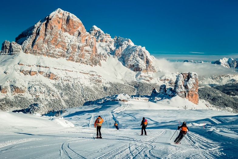
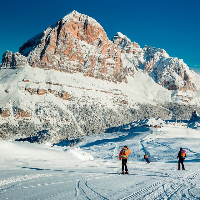
As always, a great alpine experience on and off the piste. Cortina is undergoing a major uplift in advance of the Olympics which is massively overdue. The lift system and connections have been significantly improved and it is now possible to get to the Sella Ronda with ease. Stayed in San Vito which is super pretty and has its own ski area which is much underrated and almost deserted apart from those in the know.
David Guppy from United Kingdom writes:
As always, a great alpine experience on and off the piste.
Cortina is undergoing a major uplift in advance of the Olympics which is massively overdue. The lift system and connections have been significantly improved and it is now possible to get to the Sella Ronda with ease.
Stayed in San Vito which is super pretty and has its own ski area which is much underrated and almost deserted apart from those in the know.
The Cortina skiing weather widget is available to embed on external websites free of charge. It provides a daily summary of our Cortina snow forecast and current weather conditions. Simply go to the feed configuration page and follow the 3 simple steps to grab the custom html code snippet and paste it into your own site. You can choose the snow forecast elevation (summit, mid-mountain or bottom lift) and metric/imperial units for the snow forecast feed to suit your own website…. Click here to get the code.
View detailed snow forecast for Cortina at:
snow-forecast.com


 Nearest