

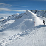
French Ski Areas Announce 2025 Summer Ski Plans
Three French ski areas have announced their opening plans in May, June and July after the winter season ends on May 4th.
Please sign in with your Snow-Forecast account details below.


Adelboden Weather (Next 3 days): The snow forecast for Adelboden is: Moderate rain (total 18.0mm), heaviest on Wed afternoon giving way to a moderate fall of snow, heaviest on Wed night. Mild temperatures (max 9°C on Tue afternoon, min 1°C on Wed night). Wind will be generally light.
Adelboden Weather (Days 4-6): Mild at first with light rain (total 2.0mm) on Sat afternoon followed by colder weather and light fall of snow, heaviest on Sat night. Freeze-thaw conditions (max 6°C on Fri afternoon, min -2°C on Sat night). Wind will be generally light.
| Resort | Snow Depth | Temp. (°C) | Wind (km/h) | Weather | ||
|---|---|---|---|---|---|---|
| Top Lift: | 0.0 m | 3 | ||||
| Middle Lift: | 4 | |||||
| Bottom Lift: | 0.0 m | 5 |
Latest snow reports near Adelboden:
Snow crystals reported from Jungfrau Mountain at 3576 metres elevation 7 kms E of Mürren but it is probably falling as rain apart from near the top of the ski area from Mürren

Tuesday 15 | Wednesday 16 | Thursday 17 | Friday 18 | Saturday 19 | Sunday 20 | Monday 21 | |||||||||||||||
AM | PM | night | AM | PM | night | AM | PM | night | AM | PM | night | AM | PM | night | AM | PM | night | AM | PM | night | |
cloudy | rain shwrs | rain shwrs | light rain | mod. rain | heavy snow | light snow | light rain | light rain | some clouds | cloudy | some clouds | cloudy | light snow | mod. snow | light snow | light snow | some clouds | light snow | light rain | light snow | |
km/h | |||||||||||||||||||||
Snow map |  |  |  |  |  |  |  | ||||||||||||||
— | — | — | — | — | 16 | 1.0 | — | — | — | — | — | — | 4 | 8 | 1.0 | — | — | — | — | 5 | |
— | 1.0 | 1.0 | 3 | 9 | — | 1.0 | 2.0 | 1.0 | — | — | — | — | 1.0 | — | — | 1.0 | — | 1.0 | 1.0 | 1.0 | |
max°C | 7 | 9 | 6 | 5 | 5 | 1 | 3 | 4 | 3 | 5 | 6 | 4 | 5 | 6 | 0 | 0 | 2 | 1 | 3 | 5 | 3 |
min°C | 5 | 9 | 4 | 5 | 2 | 1 | 1 | 3 | 2 | 3 | 5 | 2 | 3 | 1 | -2 | -1 | 1 | -1 | 1 | 4 | 1 |
3 | 9 | 1 | 3 | 1 | 1 | 1 | 3 | 2 | 3 | 3 | -1 | 0 | 0 | -2 | -1 | 1 | -4 | -3 | 2 | 1 | |
80 | 69 | 85 | 90 | 100 | 99 | 99 | 100 | 95 | 94 | 94 | 91 | 92 | 100 | 97 | 87 | 78 | 73 | 89 | 89 | 99 | |
2600 | 2750 | 2700 | 2450 | 2100 | 1900 | 2300 | 2650 | 3100 | 3100 | 3150 | 3050 | 2500 | 1900 | 1350 | 1700 | 1950 | 1350 | 2200 | 2350 | 1850 | |
6:43 | — | — | 6:41 | — | — | 6:39 | — | — | 6:37 | — | — | 6:35 | — | — | 6:33 | — | — | 6:33 | — | — | |
— | — | 8:15 | — | — | 8:17 | — | — | 8:19 | — | — | 8:20 | — | — | 8:22 | — | — | 8:22 | — | — | 8:23 | |
Moderate rain (total 18.0mm), heaviest on Wed afternoon giving way to a moderate fall of snow, heaviest on Wed night. Mild temperatures (max 9°C on Tue afternoon, min 1°C on Wed night). Wind will be generally light.
Mild at first with light rain (total 2.0mm) on Sat afternoon followed by colder weather and light fall of snow, heaviest on Sat night. Freeze-thaw conditions (max 6°C on Fri afternoon, min -2°C on Sat night). Wind will be generally light.
Latest snow reports near Adelboden:
Snow crystals reported from Jungfrau Mountain at 3576 metres elevation 7 kms E of Mürren but it is probably falling as rain apart from near the top of the ski area from Mürren
| Top snow depth: | 0 cm |
|---|---|
| Bottom snow depth: | 0 cm |
| Fresh snowfall depth: | — |
| Last snowfall: | 29 Mar 2025 |
| Snow Alerts | Create Alert |
0.2 | Bluebird Powder days Fresh snow, mostly sunny, light wind. |
|---|---|
0.8 | Powder days Fresh snow, limited sun, any wind. |
0.1 | Bluebird days Average snow, mostly sunny, light wind. |


The above table gives the weather forecast for Adelboden at the specific elevation of 1616 m. Our sophisticated weather models allow us to provide snow forecasts for the top, middle and bottom ski stations of Adelboden. To access the weather forecasts for the other elevations, use the tab navigation above the table. For a wider view of the weather, check out the Weather Map of Switzerland.
Click here to read further information on freezing levels and how we forecast our temperatures.
Overall 3.7 Based on 9 votes and 9 reviews
This year was my first time in Adelboden, Switzerland (we usually go to Austri)a. I (think I) am an advanced skier. I liked Adelboden for the possibilities. Most of the lifts were fairly new with hoods and one even had heated seats. Some tow lifts and one or two older lifts. When we were there we had lots of snow. Pistes were adequately groomed and many opportunities to go outside of the piste to get some deeper powder snow. People were friendly and the area is beautiful. What I did not like were the prices. We paid 310 Euros for a 7-day lift pass. Coffee was €5,50, a bowl of soup: €8. Parking was €5 per day (this was the first time I had to pay for this; never in Austria) and a ski locker was €8 per day per person. And above all this you have to pay 4,20F Kurtax per person per day. What you get for this amount was in no way visible for me. What I also missed were the cosy huts, on the piste, where you can sit and get something to drink. Most of them were so basic; I have seen better canteens in factories. On the bright side, it being so expensive kept people away so there were never any waiting lines at the lifts. Every disadvantage has it advantage ;-) I am not sure if we would come again to Switzerland. Maybe if the prices drop a little.
Hans from Netherlands writes:
This year was my first time in Adelboden, Switzerland (we usually go to Austri)a. I (think I) am an advanced skier. I liked Adelboden for the possibilities. Most of the lifts were fairly new with hoods and one even had heated seats. Some tow lifts and one or two older lifts. When we were there we had lots of snow. Pistes were adequately groomed and many opportunities to go outside of the piste to get some deeper powder snow. People were friendly and the area is beautiful.
What I did not like were the prices. We paid 310 Euros for a 7-day lift pass. Coffee was €5,50, a bowl of soup: €8. Parking was €5 per day (this was the first time I had to pay for this; never in Austria) and a ski locker was €8 per day per person. And above all this you have to pay 4,20F Kurtax per person per day. What you get for this amount was in no way visible for me.
What I also missed were the cosy huts, on the piste, where you can sit and get something to drink. Most of them were so basic; I have seen better canteens in factories.
On the bright side, it being so expensive kept people away so there were never any waiting lines at the lifts. Every disadvantage has it advantage ;-)
I am not sure if we would come again to Switzerland. Maybe if the prices drop a little.
The Adelboden skiing weather widget is available to embed on external websites free of charge. It provides a daily summary of our Adelboden snow forecast and current weather conditions. Simply go to the feed configuration page and follow the 3 simple steps to grab the custom html code snippet and paste it into your own site. You can choose the snow forecast elevation (summit, mid-mountain or bottom lift) and metric/imperial units for the snow forecast feed to suit your own website…. Click here to get the code.
View detailed snow forecast for Adelboden at:
snow-forecast.com


 Nearest