
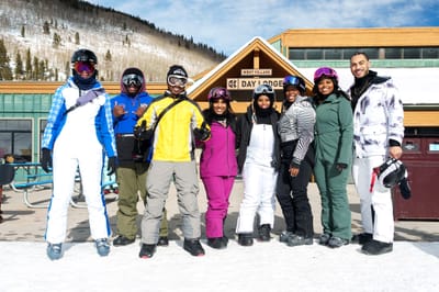
National Brotherhood of Skiers Gather in Colorado
The largest gathering of Black skiers, snowboarders and snowsports enthusiasts in the USA is getting underway in Keystone, Colorado this coming week.
Please sign in with your Snow-Forecast account details below.


Pelvoux-La Vallouise Weather (Next 3 days): The snow forecast for Pelvoux-La Vallouise is: Light rain (total 9.0mm), mostly falling on Sat afternoon. Mild temperatures (max 8°C on Sat afternoon, min 1°C on Mon night). Wind will be generally light.
Pelvoux-La Vallouise Weather (Days 4-6): Moderate rain (total 14.0mm), heaviest on Tue morning. Freeze-thaw conditions (max 7°C on Thu afternoon, min -1°C on Wed night). Wind will be generally light.
| Resort | Snow Depth | Temp. (°C) | Wind (km/h) | Weather | ||
|---|---|---|---|---|---|---|
| Top Lift: | 1.2 m | 0 | ||||
| Middle Lift: | 4 | |||||
| Bottom Lift: | 0.2 m | 8 |
Latest snow reports near Pelvoux-La Vallouise:
All lifts open, perfect snow conditions. Another glorious day. from Val Thorens
For Les Deux Alpes: Calm. Freeze-thaw conditions. No new snow. Lifts are mostly open. The pistes are icey so be careful. The off-piste has an icy crust. from Les Deux Alpes

Saturday 22 | Sunday 23 | Monday 24 | Tuesday 25 | Wednesday 26 | Thursday 27 | Friday 28 | |||||||||||||||
AM | PM | night | AM | PM | night | AM | PM | night | AM | PM | night | AM | PM | night | AM | PM | night | AM | PM | night | |
some clouds | light rain | light rain | cloudy | light rain | rain shwrs | cloudy | cloudy | cloudy | light rain | light rain | light rain | light rain | light snow | light snow | some clouds | clear | clear | cloudy | cloudy | some clouds | |
km/h | |||||||||||||||||||||
Snow map |  |  |  |  |  |  |  | ||||||||||||||
— | — | — | — | — | — | — | — | — | — | — | — | — | — | — | — | — | — | — | — | — | |
— | 2.0 | 3 | — | 2.0 | 2.0 | — | — | — | 4 | 5 | 3 | 1.0 | 1.0 | — | — | — | — | — | — | — | |
max°C | 7 | 8 | 5 | 7 | 7 | 5 | 7 | 7 | 3 | 5 | 4 | 2 | 5 | 3 | 0 | 6 | 7 | 0 | 8 | 7 | 1 |
min°C | 5 | 3 | 3 | 5 | 5 | 2 | 5 | 4 | 1 | 4 | 3 | 1 | 3 | 1 | -1 | 3 | 1 | 0 | 5 | 2 | 1 |
3 | 2 | 3 | 5 | 5 | 2 | 5 | 4 | 1 | 2 | 3 | -2 | 0 | -3 | -5 | 1 | 1 | 0 | 4 | 2 | 1 | |
86 | 76 | 96 | 82 | 90 | 95 | 80 | 70 | 92 | 86 | 94 | 95 | 80 | 77 | 90 | 69 | 63 | 73 | 56 | 59 | 63 | |
2100 | 2300 | 1950 | 2150 | 2250 | 2000 | 2150 | 2400 | 1950 | 1850 | 1950 | 1650 | 1700 | 1700 | 1300 | 1800 | 2200 | 1650 | 2300 | 2350 | 1800 | |
7:24 | — | — | 7:22 | — | — | 7:20 | — | — | 7:18 | — | — | 7:16 | — | — | 7:15 | — | — | 7:13 | — | — | |
— | 6:10 | — | — | 6:12 | — | — | 6:14 | — | — | 6:15 | — | — | 6:15 | — | — | 6:17 | — | — | 6:19 | — | |
Light rain (total 9.0mm), mostly falling on Sat afternoon. Mild temperatures (max 8°C on Sat afternoon, min 1°C on Mon night). Wind will be generally light.
Moderate rain (total 14.0mm), heaviest on Tue morning. Freeze-thaw conditions (max 7°C on Thu afternoon, min -1°C on Wed night). Wind will be generally light.
Latest snow reports near Pelvoux-La Vallouise:
All lifts open, perfect snow conditions. Another glorious day. from Val Thorens
For Les Deux Alpes: Calm. Freeze-thaw conditions. No new snow. Lifts are mostly open. The pistes are icey so be careful. The off-piste has an icy crust. from Les Deux Alpes
| Top snow depth: | 120 cm |
|---|---|
| Bottom snow depth: | 20 cm |
| Fresh snowfall depth: | — |
| Last snowfall: | 13 Feb 2025 |
| Snow Alerts | Create Alert |
0.0 | Bluebird Powder days Fresh snow, mostly sunny, light wind. |
|---|---|
0.1 | Powder days Fresh snow, limited sun, any wind. |
0.0 | Bluebird days Average snow, mostly sunny, light wind. |

The above table gives the weather forecast for Pelvoux-La Vallouise at the specific elevation of 1251 m. Our sophisticated weather models allow us to provide snow forecasts for the top, middle and bottom ski stations of Pelvoux-La Vallouise. To access the weather forecasts for the other elevations, use the tab navigation above the table. For a wider view of the weather, check out the Weather Map of France.
Click here to read further information on freezing levels and how we forecast our temperatures.
Overall 4.5 Based on 1 vote and 1 review
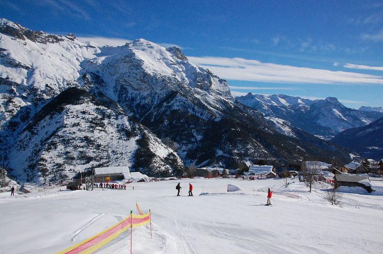
A little known resort, not far from the larger Serre Chervalier, but with pistes that are well looked after and are enough to keep a family occupied for one weeks beginner/intermediate skiing - fantastic off-piste and ski-touring. There is a second resort 10 minutes away - Puy St Vincent, which is excellent for all levels of skier(see the reviews already written) should you need more variety. The prices are lower than the big resorts and it is much more aimed at families than party animals. If you want to know more ask Alpbase.com they have a great set up renting chalets and apartments (I stayed with them in 2006/7) and will look after you very well. The valley is worth visiting in summer as well!
Chris Trevallion from France writes:
A little known resort, not far from the larger Serre Chervalier, but with pistes that are well looked after and are enough to keep a family occupied for one weeks beginner/intermediate skiing - fantastic off-piste and ski-touring. There is a second resort 10 minutes away - Puy St Vincent, which is excellent for all levels of skier(see the reviews already written) should you need more variety. The prices are lower than the big resorts and it is much more aimed at families than party animals. If you want to know more ask Alpbase.com they have a great set up renting chalets and apartments (I stayed with them in 2006/7) and will look after you very well. The valley is worth visiting in summer as well!
Click here to submit your own review of Pelvoux-La Vallouise
The Pelvoux-La Vallouise skiing weather widget is available to embed on external websites free of charge. It provides a daily summary of our Pelvoux-La Vallouise snow forecast and current weather conditions. Simply go to the feed configuration page and follow the 3 simple steps to grab the custom html code snippet and paste it into your own site. You can choose the snow forecast elevation (summit, mid-mountain or bottom lift) and metric/imperial units for the snow forecast feed to suit your own website…. Click here to get the code.
View detailed snow forecast for Pelvoux-La Vallouise at:
snow-forecast.com


 Nearest