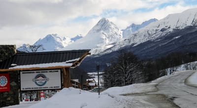
Montafon snow
Ski Austria

Montafon Snow Forecast

Weather Forecast for Montafon at 2300 m
Issued: 7 am  20 Apr 2024 (local time)

New snow in Montafon

8.7cm3.4in
Sat 20th (AM)
The snow forecast for Montafon is: A heavy fall of snow, heaviest during Sat morning. Temperatures will be well below freezing (max -8°C on Sat afternoon, min -12°C on Sun night). Wind will be generally light.

Montafon Weather (Next 3 days): The snow forecast for Montafon is: A heavy fall of snow, heaviest during Sat morning. Temperatures will be well below freezing (max -8°C on Sat afternoon, min -12°C on Sun night). Wind will be generally light.

Montafon Weather (Days 4-6): A moderate fall of snow, heaviest on Tue afternoon. Temperatures will be well below freezing (max -6°C on Thu afternoon, min -11°C on Tue night). Wind will be generally light.


Montafon Live Weather

ResortSnow DepthTemp. (°C)Wind (km/h)Weather
Top Lift: 0.0m
-9
15
light snow
Middle Lift: 
-4
10
light snow
Bottom Lift: 0.0m
1
10
light snow
Powered by Snow-Forecast.comSnow-Forecast.com
6 Day Forecast
Issued: 7 am 20 Apr 2024 / Updates in ::
Change Forecast Height
Choose Forecast
Last 6 daysScroll left for last 6 daysNow
Saturday
20
Sunday
21
Monday
22
Tuesday
23
Wednesday
24
Thursday
25
Friday
26
AM
PM
night
AM
PM
night
AM
PM
night
AM
PM
night
AM
PM
night
AM
PM
night
AM
PM
night
mod snow
light snow
light snow
light snow
light snow
light snow
light snow
light snow
light snow
light snow
light snow
light snow
light snow
light snow
light snow
light snow
light snow
light snow
cloud
light snow
light snow
mod. snow
light snow
light snow
light snow
light snow
light snow
light snow
light snow
light snow
light snow
light snow
light snow
light snow
light snow
light snow
light snow
light snow
light snow
cloudy
light snow
light snow
 km/h
15
NNW
15
NNW
5
NW
10
NW
10
N
5
E
5
NE
5
NNW
5
NNE
10
N
10
N
5
N
10
NNW
10
NNW
0
NE
0
ESE
5
SW
10
SSE
5
S
5
SSW
10
SSE
Snow map
 cm 
6
5
3
2.0
4
2.0
2.0
4
1.0
3
4
2.0
2.0
1.0
1.0
 mm 
max°C
-9
-8
-9
-9
-9
-10
-9
-8
-8
-9
-8
-9
-9
-8
-8
-8
-6
-6
-5
-3
-3
min°C
-9
-8
-11
-10
-9
-12
-10
-8
-11
-10
-8
-11
-10
-8
-10
-9
-7
-7
-6
-4
-4
chill°C 
-16
-14
-11
-10
-14
-15
-10
-8
-14
-14
-13
-16
-15
-12
-10
-9
-7
-10
-10
-7
-8
Humid% 
93
91
95
94
93
91
88
95
97
93
95
97
93
89
88
90
86
86
83
97
83
Freezing level (m
1100
1150
500
1000
1000
250
1050
1200
750
1050
1150
600
1100
1250
450
1200
1450
800
1650
1800
1350
topliftbotliftSea lvl1000m2000m3000m4000m5000m
-9-8-10-10-9-11-10-8-10-10-8-10-10-8-9-9-7-7-6-4-412-4-11-4-12-3-12-2-12-313-1353
Sunrise
6:22
6:20
6:18
6:16
6:15
6:13
6:11
Sunset
8:15
8:16
8:17
8:20
8:21
8:22
8:23

Snow Radar

Submit a report Eyeball Reporter

Latest snow reports near Montafon:

  • 18 km away from Montafon

    54 minutes ago
    weather station observation

    Rain reported from Brand at 1032 metres elevation one km S of Brandnertal (Brand und Bürserberg) but it is forecast cold enough for snow at the ski area from Brandnertal (Brand und Bürserberg)

  • 32 km away from Montafon

    54 minutes ago
    weather station observation

    Continuous light rain reported from Feldkirch at 440 metres elevation 6 kms WSW of Gröllerkopf – Übersaxen but it is forecast cold enough for snow at the ski area from Gröllerkopf – Übersaxen

  • 32 km away from Montafon

    2 hours ago
    weather station observation

    Rain reported from Feldkirch at 440 metres elevation 6 kms WSW of Gröllerkopf – Übersaxen but it is forecast cold enough for snow at the ski area from Gröllerkopf – Übersaxen

Montafon Snow Conditions

Top snow depth:0cm
Bottom snow depth:0cm
Fresh snowfall depth:28cm
Last snowfall:19 Apr 2024
Snow AlertsCreate Alert
Other resorts in Austria are reporting: powder (6) / good piste (6)

Snow History

Week 3 of April has on average:
0.3
Bluebird Powder days
Fresh snow, mostly sunny, light wind.
2.2
Powder days
Fresh snow, limited sun, any wind.
0.4
Bluebird days
Average snow, mostly sunny, light wind.