

A New Largest Ski Area in New Zealand?
The Remarkables is hoping to overtake Cardrona as New Zealand’s largest ski area under a major NZD 150 million‑plus expansion proposal lodged by owner NZSki.

Next 4 days weather summary:Moderate rain (total 16.0mm), heaviest on Fri night. Warm (max 25°C on Sat afternoon, min 17°C on Wed night). Wind will be generally light. | Days 5-7 weather summary:Heavy rain (total 70.0mm), heaviest during Sun night. Warm (max 23°C on Sun afternoon, min 14°C on Sun night). Wind will be generally light. | |||||||||||||||
Thursday 25 | Friday 26 | Saturday 27 | Sunday 28 | Monday 29 | ||||||||||||
night | AM | PM | night | AM | PM | night | AM | PM | night | AM | PM | night | AM | PM | night | |
rain shwrs | clear | some clouds | rain shwrs | clear | t-storm risk | t-storm risk | clear | t-storm risk | rain shwrs | t-storm risk | mod. rain | heavy rain | t-storm risk | rain shwrs | rain shwrs | |
km/h | ||||||||||||||||
Snow map |  |  |  |  |  |  | ||||||||||
— | — | — | — | — | — | — | — | — | — | — | — | — | — | — | — | |
mm | 1 | — | — | 3 | — | 2 | 8 | — | 2 | 16 | 1 | 9 | 31 | 3 | 3 | 2 |
max °C | 19 | 21 | 24 | 21 | 21 | 24 | 21 | 22 | 25 | 18 | 22 | 23 | 15 | 17 | 17 | 17 |
min °C | 17 | 19 | 23 | 18 | 19 | 23 | 19 | 20 | 24 | 17 | 20 | 18 | 14 | 16 | 16 | 16 |
chill °C | 17 | 19 | 23 | 18 | 19 | 23 | 19 | 20 | 24 | 17 | 20 | 18 | 13 | 16 | 16 | 16 |
Humid % | 64 | 49 | 50 | 65 | 58 | 50 | 62 | 52 | 53 | 68 | 48 | 78 | 74 | 73 | 67 | 71 |
Freeze m | 4400 | 4350 | 4600 | 4500 | 4400 | 4550 | 4550 | 4500 | 4700 | 4650 | 4500 | 4500 | 4300 | 4200 | 4250 | 4250 |
— | 5:24 | — | — | 5:26 | — | — | 5:26 | — | — | 5:26 | — | — | 5:26 | — | — | |
— | — | — | 9:19 | — | — | 9:19 | — | — | 9:19 | — | — | 9:19 | — | — | 9:19 | |
Go pro and carve into:
Avalanche information: European Avalanche Warning Services (EAWS)
Latest snow reports near Montafon:
| Top snow depth: | 0 cm |
|---|---|
| Bottom snow depth: | 0 cm |
| Fresh snowfall depth: | — |
| Last snowfall: | 16 May 2026 |
| Snow Alerts | Create Alert |
0.0 | Bluebird Powder days Fresh snow, mostly sunny, light wind. |
|---|---|
0.0 | Powder days Fresh snow, limited sun, any wind. |
0.0 | Bluebird days Average snow, mostly sunny, light wind. |
The above table gives the weather forecast for Montafon at the specific elevation of 1650 m. Our sophisticated weather models allow us to provide snow forecasts for the top, middle and bottom ski stations of Montafon. To access the weather forecasts for the other elevations, use the tab navigation above the table. For a wider view of the weather, check out the Weather Map of Austria.
Click here to read further information on freezing levels and how we forecast our temperatures.
Overall 4.1 Based on 20 votes and 3 reviews
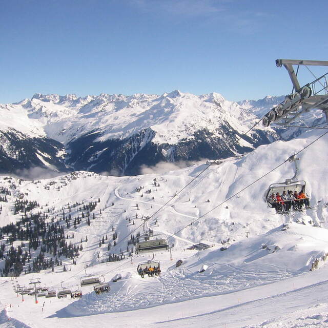
Montafon is an excellent destination in Vorarlberg. Access by car is assured also during heavy snow fall and you can choose between different parking areas in Schruns, St. Gallenkirch or Gaschurn. Offer of perfectly groomed slopes goes from easy ones in Kapell area to black ones. This season, with a lot of snow, the Black Scorpion in the back of Versettla was fantastic. But, in general, all very large slopes. Guaranteed good rides also on weekends when it is crowded. I suggest, also, the Hochjochtotal from 2400m down to 700m in Schruns or from Sennigrat to Silbertal. Restaurants and bars are available everywhere and with the sun shining nothing's better than to chill out on the terrace. A good tip is to ski during weekdays, to avoid crowded slopes and traffic jams early in the morning and later in the afternoon.
Massimo Anselmi from Italy writes:
Montafon is an excellent destination in Vorarlberg. Access by car is assured also during heavy snow fall and you can choose between different parking areas in Schruns, St. Gallenkirch or Gaschurn.
Offer of perfectly groomed slopes goes from easy ones in Kapell area to black ones. This season, with a lot of snow, the Black Scorpion in the back of Versettla was fantastic. But, in general, all very large slopes. Guaranteed good rides also on weekends when it is crowded.
I suggest, also, the Hochjochtotal from 2400m down to 700m in Schruns or from Sennigrat to Silbertal.
Restaurants and bars are available everywhere and with the sun shining nothing's better than to chill out on the terrace.
A good tip is to ski during weekdays, to avoid crowded slopes and traffic jams early in the morning and later in the afternoon.


 Nearest