
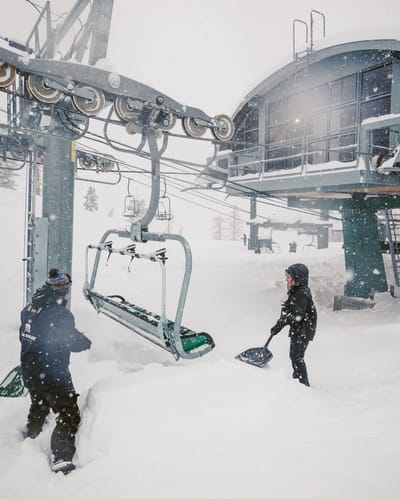
Over A Metre (40”) Of Snowfall in 24 Hours At Californian Ski Area
California has had some huge snowfalls, as forecast, over the last 24 hours.
Please sign in with your Snow-Forecast account details below.

Grainau Weather (Next 3 days): The snow forecast for Grainau is: A light covering of new snow, mostly falling on Sun afternoon. Temperatures will be below freezing (max -3°C on Sat morning, min -7°C on Sun night). Wind will be generally light.
Grainau Weather (Days 4-6): A dusting of new snow. Temperatures will be below freezing (max 0°C on Wed afternoon, min -8°C on Mon night). Wind will be generally light.
| Resort | Snow Depth | Temp. (°C) | Wind (km/h) | Weather | ||
|---|---|---|---|---|---|---|
| Top Lift: | -11 | |||||
| Middle Lift: | -6 | |||||
| Bottom Lift: | -1 |
Latest snow reports near Grainau:
Light rain reported from Flughafen Innsbruck Automatic Weather Station at 593 metres elevation only 4 kms WNW of Muttereralm but it is forecast cold enough for snow at the ski area from Muttereralm
Drizzle reported from Flughafen Innsbruck Automatic Weather Station at 593 metres elevation only 4 kms WNW of Muttereralm but it is forecast cold enough for snow at the ski area from Muttereralm
Light rain reported from Flughafen Innsbruck Automatic Weather Station at 721 metres elevation 5 kms WNW of Muttereralm but it is forecast cold enough for snow at higher elevations in the ski area from Muttereralm

Friday 14 | Saturday 15 | Sunday 16 | Monday 17 | Tuesday 18 | Wednesday 19 | Thursday 20 | |||||||||||||||
AM | PM | night | AM | PM | night | AM | PM | night | AM | PM | night | AM | PM | night | AM | PM | night | AM | PM | night | |
light snow | light snow | light snow | light snow | light snow | light snow | light snow | light snow | light snow | light snow | light snow | snow shwrs | clear | clear | clear | clear | clear | clear | clear | clear | clear | |
km/h | |||||||||||||||||||||
Snow map |  |  |  |  |  |  |  | ||||||||||||||
— | 1.0 | — | 1.0 | — | — | 1.0 | 3 | 2.0 | — | 1.0 | — | — | — | — | — | — | — | — | — | — | |
— | — | — | — | — | — | — | — | — | — | — | — | — | — | — | — | — | — | — | — | — | |
max°C | -5 | -5 | -4 | -3 | -4 | -4 | -5 | -5 | -6 | -6 | -7 | -7 | -3 | -2 | -2 | -1 | 0 | -1 | 2 | 3 | 2 |
min°C | -6 | -5 | -4 | -4 | -4 | -6 | -5 | -6 | -7 | -6 | -7 | -8 | -5 | -3 | -3 | -2 | 0 | -1 | 0 | 2 | 2 |
-6 | -5 | -7 | -7 | -4 | -6 | -8 | -9 | -10 | -10 | -12 | -13 | -9 | -3 | -3 | -2 | -2 | -1 | 0 | 2 | 1 | |
84 | 94 | 91 | 93 | 93 | 89 | 97 | 97 | 96 | 59 | 73 | 51 | 41 | 47 | 47 | 52 | 49 | 52 | 47 | 39 | 35 | |
1250 | 1250 | 1050 | 1200 | 1150 | 1050 | 1050 | 1050 | 900 | 1050 | 1100 | 0 | 1100 | 1750 | 1600 | 1600 | 2150 | 1950 | 2150 | 2700 | 2700 | |
6:31 | — | — | 6:28 | — | — | 6:26 | — | — | 6:24 | — | — | 6:22 | — | — | 6:20 | — | — | 6:18 | — | — | |
— | 6:19 | — | — | 6:20 | — | — | 6:22 | — | — | 6:22 | — | — | 6:24 | — | — | 6:25 | — | — | 6:28 | — | |
A light covering of new snow, mostly falling on Sun afternoon. Temperatures will be below freezing (max -3°C on Sat morning, min -7°C on Sun night). Wind will be generally light.
A dusting of new snow. Temperatures will be below freezing (max 0°C on Wed afternoon, min -8°C on Mon night). Wind will be generally light.
Latest snow reports near Grainau:
Light rain reported from Flughafen Innsbruck Automatic Weather Station at 593 metres elevation only 4 kms WNW of Muttereralm but it is forecast cold enough for snow at the ski area from Muttereralm
Drizzle reported from Flughafen Innsbruck Automatic Weather Station at 593 metres elevation only 4 kms WNW of Muttereralm but it is forecast cold enough for snow at the ski area from Muttereralm
Light rain reported from Flughafen Innsbruck Automatic Weather Station at 721 metres elevation 5 kms WNW of Muttereralm but it is forecast cold enough for snow at higher elevations in the ski area from Muttereralm
| Top snow depth: | — |
|---|---|
| Bottom snow depth: | — |
| Fresh snowfall depth: | 17 cm |
| Last snowfall: | 13 Mar 2025 |
| Snow Alerts | Create Alert |
1.0 | Bluebird Powder days Fresh snow, mostly sunny, light wind. |
|---|---|
1.7 | Powder days Fresh snow, limited sun, any wind. |
1.3 | Bluebird days Average snow, mostly sunny, light wind. |
The above table gives the weather forecast for Grainau at the specific elevation of 2156 m. Our sophisticated weather models allow us to provide snow forecasts for the top, middle and bottom ski stations of Grainau. To access the weather forecasts for the other elevations, use the tab navigation above the table. For a wider view of the weather, check out the Weather Map of Germany.
Click here to read further information on freezing levels and how we forecast our temperatures.
What a beautiful village to stay in for a winter holiday and extremely well priced. Rooms with breakfast from between 18 euros up to whatever you wish. I love the authenticity of Grainau, very few speak English and all are very helpful. Free bus service with the guest card, so can just jump on and in 10 mins be at the ski station. Can also use the Cog train for free, except if you need cable cars up or gondolas in Garmisch. Perfect location for a truely authentic Bavarian holiday. Delicious food too!
Louisa James from United Kingdom writes:
What a beautiful village to stay in for a winter holiday and extremely well priced. Rooms with breakfast from between 18 euros up to whatever you wish. I love the authenticity of Grainau, very few speak English and all are very helpful. Free bus service with the guest card, so can just jump on and in 10 mins be at the ski station. Can also use the Cog train for free, except if you need cable cars up or gondolas in Garmisch. Perfect location for a truely authentic Bavarian holiday. Delicious food too!
The Grainau skiing weather widget is available to embed on external websites free of charge. It provides a daily summary of our Grainau snow forecast and current weather conditions. Simply go to the feed configuration page and follow the 3 simple steps to grab the custom html code snippet and paste it into your own site. You can choose the snow forecast elevation (summit, mid-mountain or bottom lift) and metric/imperial units for the snow forecast feed to suit your own website…. Click here to get the code.
View detailed snow forecast for Grainau at:
snow-forecast.com


 Nearest