

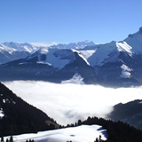
Massive Snowfall in the Alps
A huge snowfall is underway in the Alps, by far the biggest of the 24-25 season.
Please sign in with your Snow-Forecast account details below.


Chatel Weather (Next 3 days): The snow forecast for Chatel is: A dusting of snow turning to light rain (total 9.0mm) on Sun afternoon. Mild temperatures (max 5°C on Tue afternoon, min 1°C on Sun afternoon). Wind will be generally light.
Chatel Weather (Days 4-6): Moderate rain (total 12.0mm) heaviest on Wed night, then becoming colder with a dusting of snow on Wed night. Freeze-thaw conditions (max 7°C on Wed afternoon, min 0°C on Thu night). Wind will be generally light.
| Resort | Snow Depth | Temp. (°C) | Wind (km/h) | Weather | ||
|---|---|---|---|---|---|---|
| Top Lift: | 0 | |||||
| Middle Lift: | 2 | |||||
| Bottom Lift: | 6 |
Latest snow reports near Chatel:

Sunday 20 | Monday 21 | Tuesday 22 | Wednesday 23 | Thursday 24 | Friday 25 | Saturday 26 | |||||||||||||||
AM | PM | night | AM | PM | night | AM | PM | night | AM | PM | night | AM | PM | night | AM | PM | night | AM | PM | night | |
light rain | light snow | rain shwrs | cloudy | rain shwrs | rain shwrs | cloudy | cloudy | some clouds | rain shwrs | light rain | light snow | snow shwrs | rain shwrs | snow shwrs | some clouds | clear | clear | some clouds | cloudy | cloudy | |
km/h | |||||||||||||||||||||
Snow map |  |  |  |  |  |  |  | ||||||||||||||
— | 2.0 | — | — | — | — | — | — | — | — | — | 2.0 | — | — | — | — | — | — | — | — | — | |
1.0 | 2.0 | 2.0 | — | 3 | 1.0 | — | — | — | 1.0 | 2.0 | 5 | 1.0 | 3 | — | — | — | — | — | — | — | |
max°C | 2 | 4 | 4 | 3 | 4 | 3 | 4 | 5 | 5 | 5 | 7 | 5 | 2 | 3 | 2 | 3 | 7 | 5 | 6 | 8 | 6 |
min°C | 2 | 1 | 1 | 1 | 4 | 1 | 2 | 5 | 3 | 3 | 5 | 1 | 1 | 3 | 0 | 1 | 6 | 3 | 3 | 7 | 4 |
2 | 1 | -1 | -2 | 2 | 1 | 2 | 4 | 3 | 3 | 3 | -3 | -2 | 0 | -2 | -2 | 4 | 3 | 3 | 6 | 4 | |
95 | 86 | 83 | 77 | 85 | 87 | 75 | 75 | 83 | 75 | 61 | 97 | 80 | 77 | 82 | 79 | 63 | 71 | 54 | 52 | 61 | |
2100 | 2250 | 1900 | 2150 | 2250 | 2050 | 2300 | 2450 | 2300 | 2400 | 2550 | 2000 | 2000 | 2150 | 1800 | 2250 | 2800 | 3100 | 3000 | 2850 | 2550 | |
6:37 | — | — | 6:35 | — | — | 6:33 | — | — | 6:33 | — | — | 6:31 | — | — | 6:28 | — | — | 6:28 | — | — | |
— | — | 8:24 | — | — | 8:27 | — | — | 8:28 | — | — | 8:29 | — | — | 8:30 | — | — | 8:31 | — | — | 8:32 | |
A dusting of snow turning to light rain (total 9.0mm) on Sun afternoon. Mild temperatures (max 5°C on Tue afternoon, min 1°C on Sun afternoon). Wind will be generally light.
Moderate rain (total 12.0mm) heaviest on Wed night, then becoming colder with a dusting of snow on Wed night. Freeze-thaw conditions (max 7°C on Wed afternoon, min 0°C on Thu night). Wind will be generally light.
Latest snow reports near Chatel:
| Top snow depth: | — |
|---|---|
| Bottom snow depth: | — |
| Fresh snowfall depth: | — |
| Last snowfall: | 17 Apr 2025 |
| Snow Alerts | Create Alert |
0.2 | Bluebird Powder days Fresh snow, mostly sunny, light wind. |
|---|---|
0.5 | Powder days Fresh snow, limited sun, any wind. |
0.2 | Bluebird days Average snow, mostly sunny, light wind. |


The above table gives the weather forecast for Chatel at the specific elevation of 1701 m. Our sophisticated weather models allow us to provide snow forecasts for the top, middle and bottom ski stations of Chatel. To access the weather forecasts for the other elevations, use the tab navigation above the table. For a wider view of the weather, check out the Weather Map of France.
Click here to read further information on freezing levels and how we forecast our temperatures.
Overall 4.4 Based on 58 votes and 66 reviews
Bij uitstek het skigebied voor lange tochten en veel afwisseling. Chatel ligt in het hart van het gebied, waardoor je makkelijk in Zwitserland en Avoriaz komt. De Apres ski is gemoedelijk en gezellig, niet uitbundig met hollandse hits, maar dat is wat mij betreft een pluspunt. De barretjes, winkels en zeker ook de restaurants zijn van goed niveau. Mooi prijsniveau en van lokaal tot Italiaans etc. Zowel op de pistes (wel reserveren), als in het dorp (ook daar beter reserveren. Wij komen er zeker terug!
B from Netherlands writes:
Bij uitstek het skigebied voor lange tochten en veel afwisseling. Chatel ligt in het hart van het gebied, waardoor je makkelijk in Zwitserland en Avoriaz komt. De Apres ski is gemoedelijk en gezellig, niet uitbundig met hollandse hits, maar dat is wat mij betreft een pluspunt. De barretjes, winkels en zeker ook de restaurants zijn van goed niveau. Mooi prijsniveau en van lokaal tot Italiaans etc. Zowel op de pistes (wel reserveren), als in het dorp (ook daar beter reserveren. Wij komen er zeker terug!
The Chatel skiing weather widget is available to embed on external websites free of charge. It provides a daily summary of our Chatel snow forecast and current weather conditions. Simply go to the feed configuration page and follow the 3 simple steps to grab the custom html code snippet and paste it into your own site. You can choose the snow forecast elevation (summit, mid-mountain or bottom lift) and metric/imperial units for the snow forecast feed to suit your own website…. Click here to get the code.
View detailed snow forecast for Chatel at:
snow-forecast.com


 Nearest