

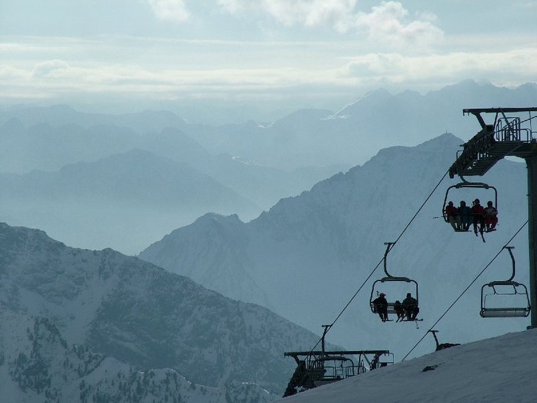
Massive Snowfall in the Alps
A huge snowfall is underway in the Alps, by far the biggest of the 24-25 season.
Please sign in with your Snow-Forecast account details below.


Champoluc Weather (Next 3 days): The snow forecast for Champoluc is: Moderate rain (total 11.0mm) heaviest on Tue night, then becoming colder with a dusting of snow on Wed night. Freeze-thaw conditions (max 5°C on Tue afternoon, min -1°C on Wed night). Wind will be generally light.
Champoluc Weather (Days 4-6): Light rain (total 7.0mm) at first, then becoming colder with a dusting of snow on Sat night. Freeze-thaw conditions (max 6°C on Fri afternoon, min -1°C on Sat night). Wind will be generally light.
| Resort | Snow Depth | Temp. (°C) | Wind (km/h) | Weather | ||
|---|---|---|---|---|---|---|
| Top Lift: | -2 | |||||
| Middle Lift: | 2 | |||||
| Bottom Lift: | 5 |
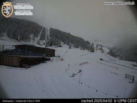
Latest snow reports near Champoluc:

Tuesday 22 | Wednesday 23 | Thursday 24 | Friday 25 | Saturday 26 | Sunday 27 | ||||||||||||||
night | AM | PM | night | AM | PM | night | AM | PM | night | AM | PM | night | AM | PM | night | AM | PM | night | |
rain shwrs | clear | light rain | rain shwrs | rain shwrs | rain shwrs | snow shwrs | clear | clear | clear | clear | clear | some clouds | some clouds | mod. rain | snow shwrs | clear | clear | rain shwrs | |
km/h | |||||||||||||||||||
Snow map |  |  |  |  |  |  |  | ||||||||||||
— | — | — | — | — | — | 1.0 | — | — | — | — | — | — | — | — | 4 | — | — | — | |
1.0 | — | 1.0 | 3 | 1.0 | 3 | 2.0 | — | — | — | — | — | — | — | 7 | — | — | — | 1.0 | |
max°C | 2 | 3 | 5 | 4 | 4 | 5 | 3 | 1 | 3 | 1 | 4 | 6 | 4 | 5 | 5 | 2 | 3 | 4 | 2 |
min°C | 0 | 1 | 5 | 2 | 2 | 4 | -1 | -1 | 3 | 0 | 1 | 6 | 3 | 3 | 3 | -1 | 0 | 4 | -1 |
-2 | 1 | 5 | 2 | 2 | 2 | -5 | -6 | 0 | -4 | -2 | 6 | 1 | 3 | 2 | -5 | -3 | 2 | -4 | |
77 | 69 | 79 | 83 | 74 | 80 | 79 | 61 | 58 | 65 | 43 | 59 | 64 | 52 | 90 | 75 | 42 | 55 | 57 | |
2200 | 2600 | 2750 | 2500 | 2600 | 2750 | 2050 | 2250 | 2550 | 2100 | 2650 | 2950 | 2850 | 2850 | 2600 | 2100 | 2450 | 2650 | 2100 | |
— | 6:31 | — | — | 6:30 | — | — | 6:28 | — | — | 6:26 | — | — | 6:24 | — | — | 6:22 | — | — | |
— | — | — | 8:23 | — | — | 8:24 | — | — | 8:25 | — | — | 8:28 | — | — | 8:29 | — | — | 8:30 | |
Moderate rain (total 11.0mm) heaviest on Tue night, then becoming colder with a dusting of snow on Wed night. Freeze-thaw conditions (max 5°C on Tue afternoon, min -1°C on Wed night). Wind will be generally light.
Light rain (total 7.0mm) at first, then becoming colder with a dusting of snow on Sat night. Freeze-thaw conditions (max 6°C on Fri afternoon, min -1°C on Sat night). Wind will be generally light.
Latest snow reports near Champoluc:
| Top snow depth: | — |
|---|---|
| Bottom snow depth: | — |
| Fresh snowfall depth: | 11 cm |
| Last snowfall: | 20 Apr 2025 |
| Snow Alerts | Create Alert |
0.4 | Bluebird Powder days Fresh snow, mostly sunny, light wind. |
|---|---|
1.3 | Powder days Fresh snow, limited sun, any wind. |
0.6 | Bluebird days Average snow, mostly sunny, light wind. |


The above table gives the weather forecast for Champoluc at the specific elevation of 2146 m. Our sophisticated weather models allow us to provide snow forecasts for the top, middle and bottom ski stations of Champoluc. To access the weather forecasts for the other elevations, use the tab navigation above the table. For a wider view of the weather, check out the Weather Map of Italy.
Click here to read further information on freezing levels and how we forecast our temperatures.
Overall 4.2 Based on 24 votes and 23 reviews
Went in Feb 2025 Still deserted most days, no queues anywhere, except on a Saturday if its sunny, then it gets very busy. Don't let the piste map put you off. They have regraded several pistes. Black C1 down to the village used to be a red. It is still an easy red, definitely not a black. Black C6 likewise, apart from the very top, which can be tricky in poor conditions, is also really a red.
bradley from United Kingdom writes:
Went in Feb 2025
Still deserted most days, no queues anywhere, except on a Saturday if its sunny, then it gets very busy.
Don't let the piste map put you off. They have regraded several pistes. Black C1 down to the village used to be a red. It is still an easy red, definitely not a black. Black C6 likewise, apart from the very top, which can be tricky in poor conditions, is also really a red.
The Champoluc skiing weather widget is available to embed on external websites free of charge. It provides a daily summary of our Champoluc snow forecast and current weather conditions. Simply go to the feed configuration page and follow the 3 simple steps to grab the custom html code snippet and paste it into your own site. You can choose the snow forecast elevation (summit, mid-mountain or bottom lift) and metric/imperial units for the snow forecast feed to suit your own website…. Click here to get the code.
View detailed snow forecast for Champoluc at:
snow-forecast.com


 Nearest