Powder Returns: Fresh Snowfall and Storms Transform North America’s Ski Resorts
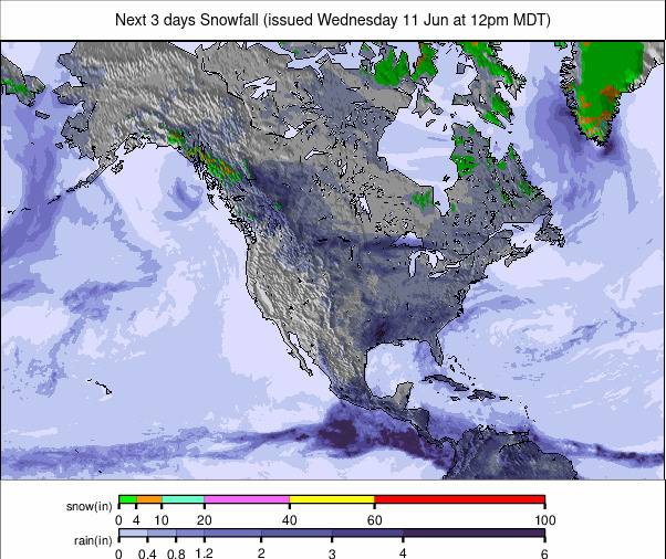
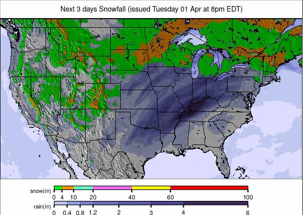
Updated March 5, 2025: Fresh snow hits the Rockies with up to 20” (50cm) at Snowbird, while California braces for a 16” (40cm) dump.
- Rockies reloaded: Fresh snowfall brings powder boost across the region
- West Coast storm incoming with up to 16” expected in California’s resorts
- Midwest’s last winter blast with foot-deep snowfall before a sunny weekend
- East Coast delivers as Vermont resorts see biggest snowfalls in the U.S.
- Western Canada basks in spring sun as snow depths hold strong
NORTH AMERICA OVERVIEW
It's been a largely dry week for much of North America after last week's heavy falls in the Pacific Northwest. Springtime is also beginning to make its presence felt with rising temperatures leading to some thawing and also to what would have been snowfall a few weeks ago, instead arriving as rain or sleet. The main weather factor though has been sunshine and as more or less all ski slopes are open across the continent conditions are pretty good, overall, when it's not raining at least, pretty much everywhere. That said we have seen some decent falls in the Rockies over the past 24 hours, with 8” (20cm) accumulations reported as far south as Arizona.
ROCKIES REPORT
Snowfalls returned to the Rockies at the start of this week after a fairly warm and sunny end to last. Temperatures were climbing up into the 40s at resort bases which has had some impact on snow levels and snow quality although most ski areas in the region have plenty of snow lying meaning no real impact on the amount of terrain open at least. Snowfalls over the past few days have mostly been in the 2-4 inch (5-10cm) per-24-hour area, so nothing too exciting for most, but still enough for a good powder top-up on higher slopes. Some resorts actually did better though, with Aspen (45/68” / 112/170cm), Breckenridge (65/65” / 163/163cm) and Vail (73/73” / 183/183cm) in Colorado reporting about 8” (20cm) each and the same for the Arizona Snowbowl. Snowbird (108/108” / 270/270cm) in Utah claims 20” (50cm) since Sunday.
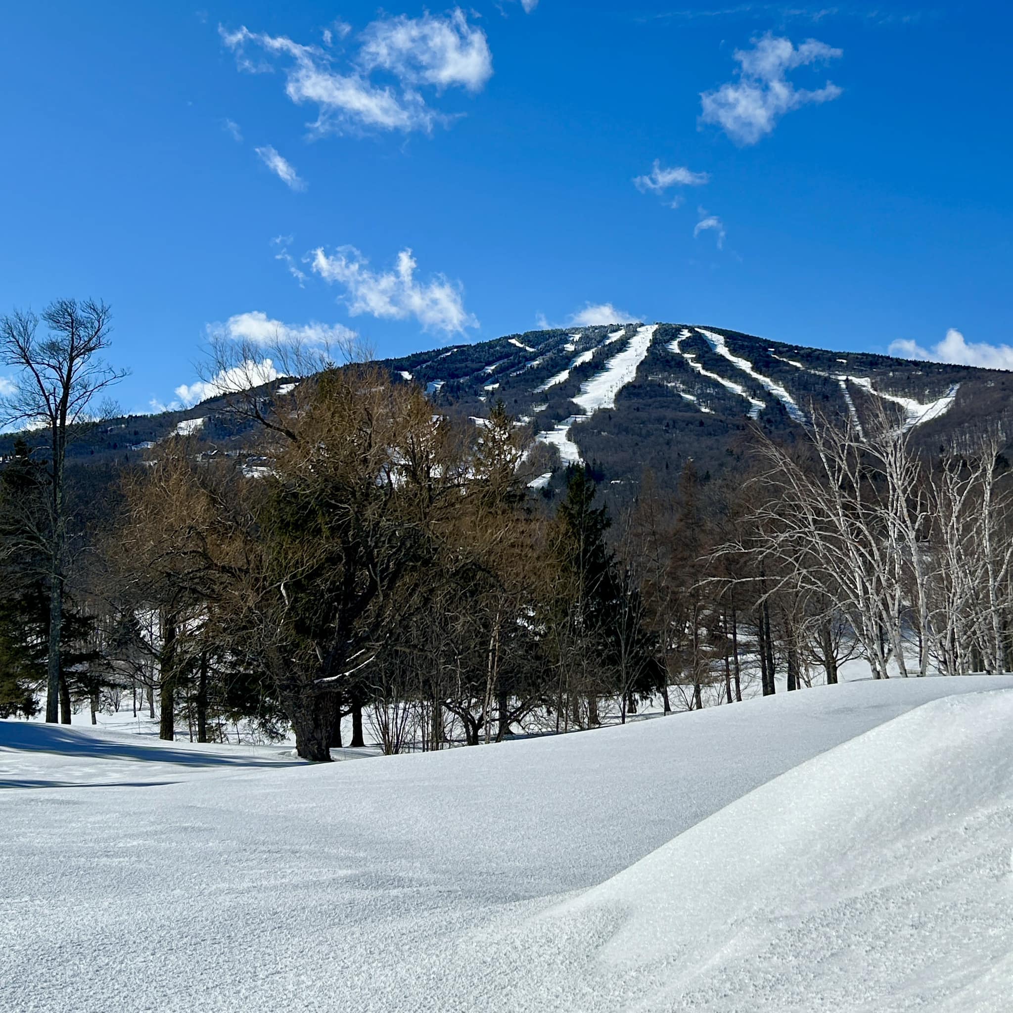
ROCKIES FORECAST
Staying unsettled with light snowfall is expected through the latter half of the week. Temperatures are largely below freezing, but getting a few degrees into positive numbers at resort bases.
WEST COAST REPORT
It's been a fairly dry week, comparatively speaking, on the West Coast with plenty of sunshine in California and relatively light snowfalls up in the Pacific Northwest. However, a front moving in as we publish this week’s report is expected to dump up to 16” (40cm), mostly in California, where Mammoth Mountain (220/390cm / 88/156”) is already posting the deepest snow in the country and North America (and indeed the world, outside of Japan).
WEST COAST FORECAST
A snowy Wednesday/Thursday along the west coast with 10-40cm (4-16") accumulations expected, heaviest in the south. Temperatures stay cold in most areas, with lows in the teens Fahrenheit overnight on high slopes, and highs getting just a few degrees above freezing overnight.
MIDWEST REPORT
Warmer weather over the past week in the Midwest has led ski areas there to reassure their customer base that on their slopes the snow is still lying and everything remains open. Most Midwestern ski areas do tend to close their seasons through March, but for the majority, it's not until the end of the month with some remaining open into April and some years a few even into May. That said, temperatures have been climbing into the 40s in the afternoons even on ski slopes, so there’s definitely a spring feel in the air. Forecast snow has also been falling as sleet and rain on some lower slopes in Minnesota and Michigan. Wisconsin’s Trollhaugen (12/48” / 30/45”) was among areas closing this week during rain showers to allow crews to regroom and improve conditions ahead of the weekend. Michigan’s Marquette Mountain (24/72” / 60/180cm) is posting the region’s deepest snow.
MIDWEST FORECAST
Temperatures have been falling away and we are set to see a last(?) blast of winter midweek with temperatures down into the teens, strong winds and up to a foot (30cm) of snowfall expected in 36 hours for some parts of the Midwest. Drier, sunnier and warmer weather is expected after that though for the remainder of this week, however, temperatures are currently forecast to drop back down into the teens and more snowfall arrive at the weekend.
EAST COAST REPORT
The Northeast has once again seen some of the biggest snowfalls in the US (and the world, outside Japan), over the last week. Nothing huge but then falls have been low worldwide over the last seven days. Vermont saw some of the biggest falls with Smugglers Notch (15/50” / 37/125cm) posting a 12” accumulation. Jay Peak (36/85” / 90/212cm) reported the same over a 72-hour period over the weekend. The news wasn’t 100% good as a spike in warm temperatures at one point brought periods of sleet or rain to some lower slopes and strong winds were also a factor at times, but for most, it meant the ongoing flow of fresh snow to enjoy.

EAST COAST FORECAST
Continuing unsettled with temperature fluctuations means there’s a mic of snow showers, sleet and rainfall in the mix as well as more gusty to strong winds at times.
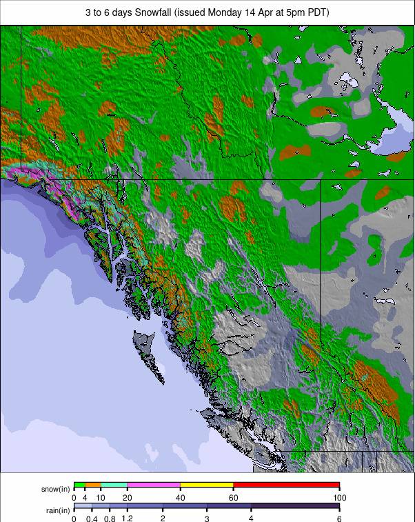
WESTERN CANADA REPORT
Springtime is here in western Canada, with warmer temperatures (although not THAT warm) and some centres extending their opening hours by 30 minutes or so in the afternoons to make the most of the increased daylight. After last week’s big snowfalls, the past few days have seen drier weather and plenty of sunshine, although a weak front is currently bringing some snowfall – just a few centimetres/an inch or so – to the region. All centres in Alberta and BC are pretty much fully open and reporting healthy snow depths. Canada's deepest is at Mt Washington (205/395cm / 82/158") on Vancouver Island.
WESTERN CANADA FORECAST
It’s looking like there will be a dry and sunny end to the week, with temperatures ranging from -15C still on higher slopes overnight to daytime highs of +3 to +6C.
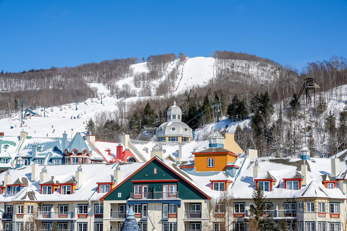
EASTERN CANADA REPORT
A mixed picture in eastern Canada – in most ways conditions continue to be the best they’ve been all season, with almost all areas now fully open and with fairly healthy snow depths. There have also been some fresh snow showers giving the slopes a refresh. The only downside at present is rising spring temperatures meaning that sleet and rain are falling midweek, although that’s due to return to snowfall later this week. Mont Tremblant (155/275cm / 62/130”) continues to post by far the deepest snow in the region and is almost 100% open.
EASTERN CANADA FORECAST
The warmer, wetter weather should move on by the end of Wednesday, leaving clear skies and falling temperatures through Thursday before a fresh band of precipitation, this one expected to be falling as snow, moves through to the end of the week.


