Late-season jackpot for France and Italy with metre-plus snowfalls reported
Updated April 23, 2025: Europe’s wildest snowstorm in years dumped 5 feet (155 cm) in 36 hours—some resorts even shut down. Avalanche danger? Maxed out. Read the full report here.

- Western Alps hit by heaviest snowfall in decades, avalanche risk peaked at max
- Saas Fee and Zermatt buried under 160 cm snow, resorts briefly cut off
- Most European ski areas now closed, but high-altitude resorts extend into May
- Scandinavia holding strong with deep snow and near-Arctic late-season conditions
EUROPE OVERVIEW
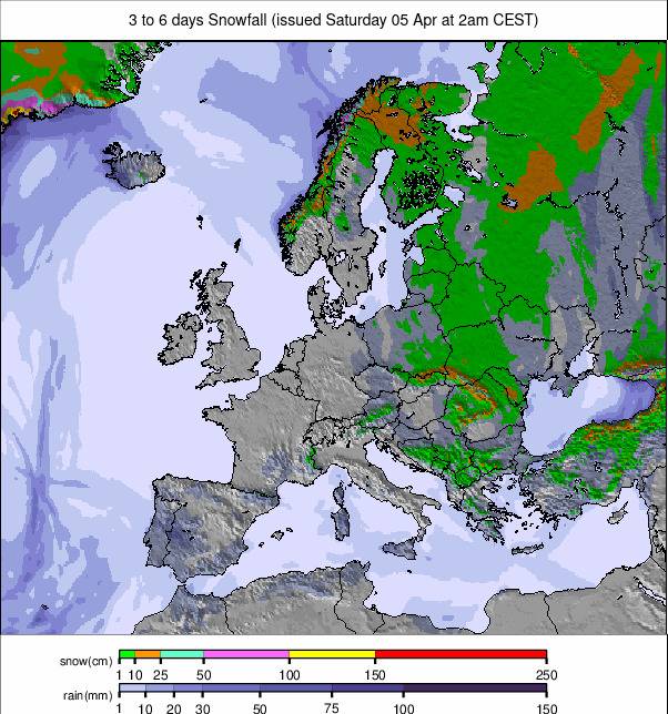
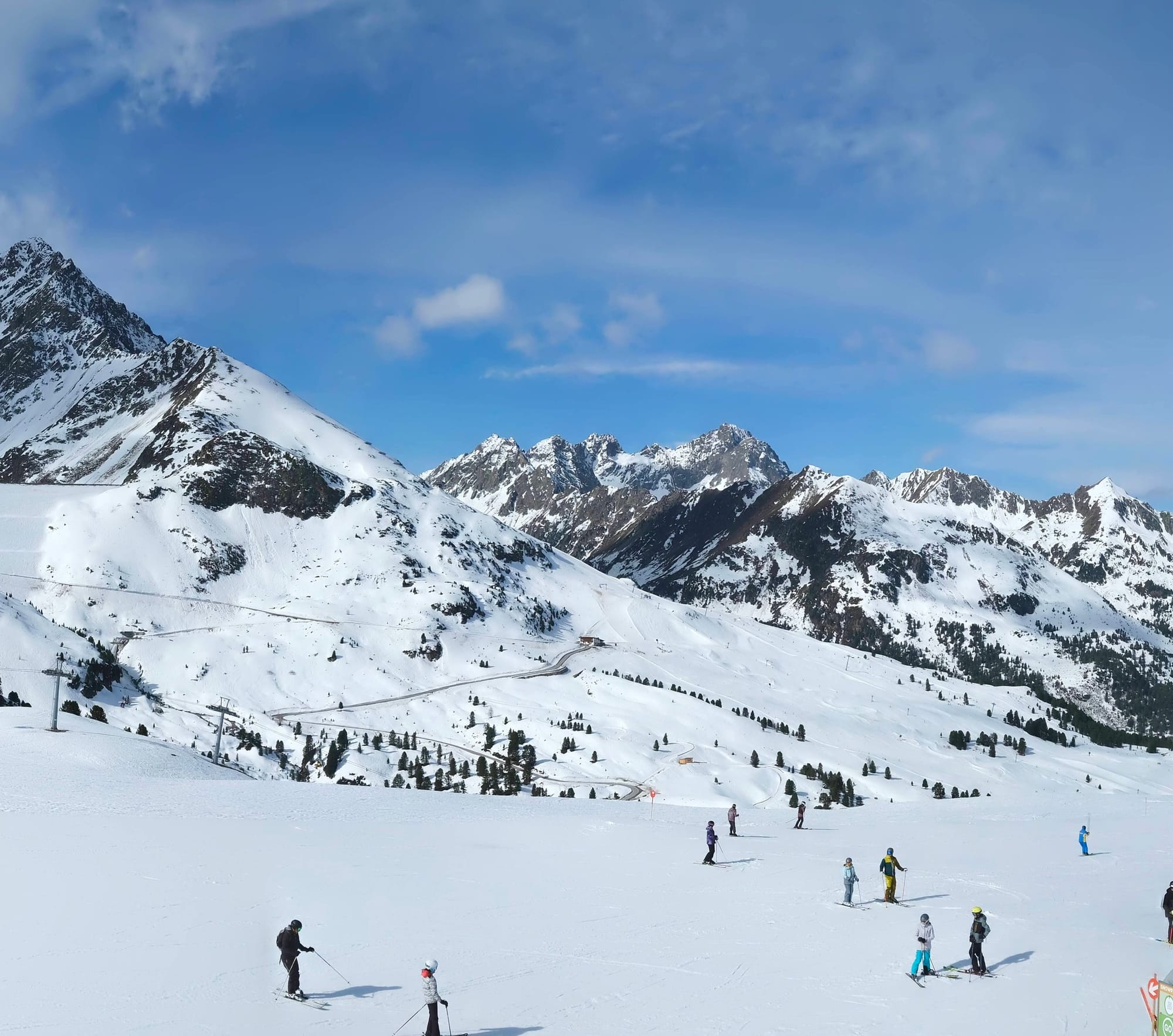
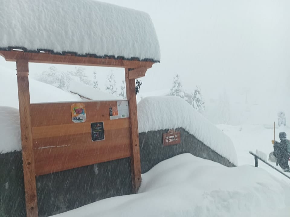
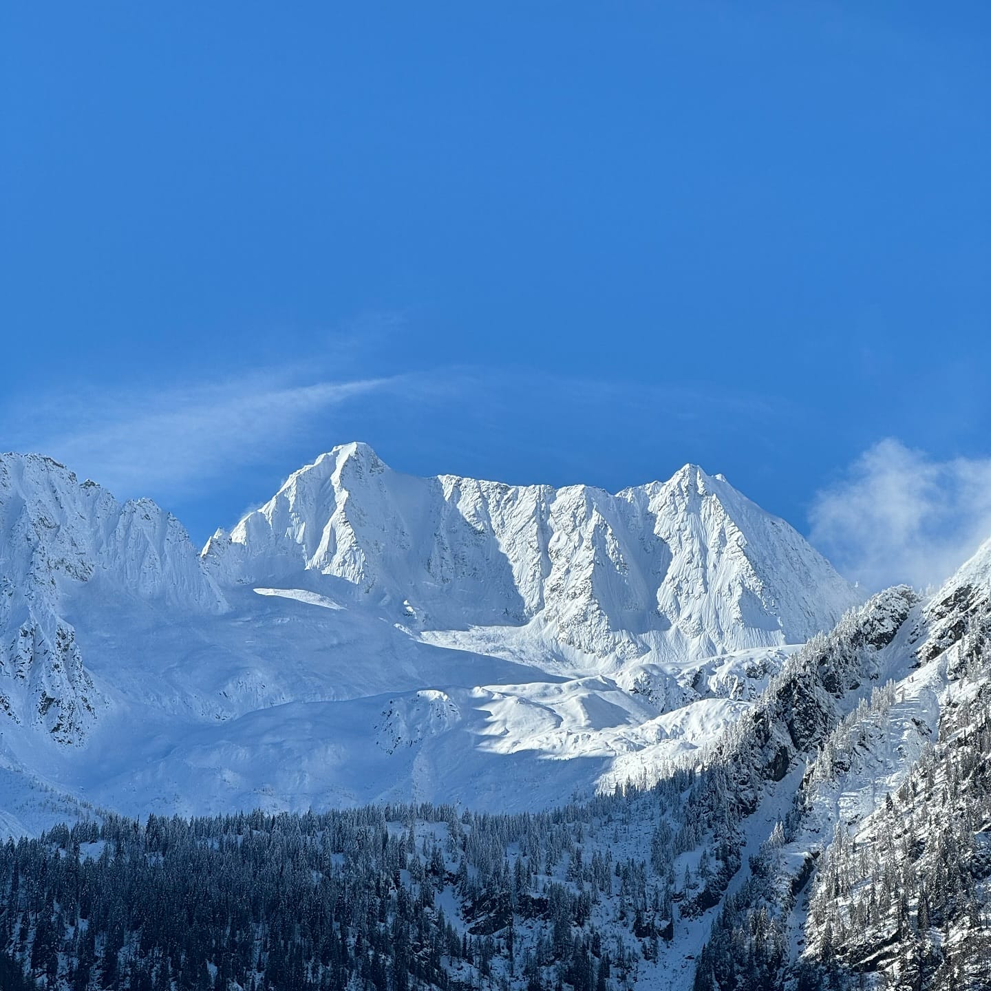
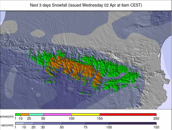
It all happened before last weekend, but the snowfall that impacted the Western Alps was the heaviest of the season by some distance, depositing up to 155 cm (5 feet) of snow in under 36 hours. That amount of snowfall, of course, brought lots of safety and practical issues. For a while, the most impacted resorts issued "stay indoors" orders due to the extreme avalanche danger. Some Swiss resorts were cut off, reporting the most intense snowfall, some claimed, since 1986. Power lines also went down, and the avalanche danger hit the rare maximum of 5 out of 5. By Friday, though, slopes were starting to reopen, although maximum caution was urged due to the ongoing high avalanche danger. Resorts like Val Thorens, after reporting a 110 cm 36-hour forecast, were heralding the fact that they were still open for another fortnight and now had fabulous snow conditions for late-season arrivals. Of course, Val Thorens and the few hundred areas elsewhere in Europe still open after Easter are the exception, with 95% of ski areas now closed for the season across the continent. Outside the Alps and Scandinavia, only a handful of places are still operating as we approach the final weekend of the month. The ski season is believed to be over now in Eastern Europe, Scotland, and the Pyrenees, with most of the few ski areas that had remained open up to the Easter weekend closing for the 24–25th once that was over. Other than the big drama of the huge snowfall in the Western Alps, it’s been a much more normal late April week in most parts of the continent, although the Pyrenees, Western Alps, and northern Scandinavia all saw some good snowfalls of around 30 cm in the past seven days. The season appears to be over in Scotland and Eastern Europe, although Slovakia's Jasna has announced that it plans to reopen its lifts this coming Saturday and Sunday.
AUSTRIA REPORT
Much of Austria missed the huge snowfalls up to last weekend that hit a little further west, but the country’s glaciers did get decent accumulations, typically around the 50 cm (20”) mark, to give powder conditions for the Easter weekend and build a bigger base for their May—and in a few cases, June—skiing weeks ahead. Otherwise, accumulations were mostly in the 10–20 cm (4–8") range, with rain rather than snow below 2,000 m. About a dozen Austrian ski areas remain open, with the Stubai (20/260 cm / 8/104”) now posting the country’s deepest snow after being one of those reporting a 50 cm (20”) fall before the weekend. It’s open through to 11th May.
AUSTRIA FORECAST
Rather overcast skies in many areas for the next few days, with valley temperatures reaching +20°C or higher, but on higher slopes where skiing continues, the temperature range is more like -5°C to +5°C through the 24-hour cycle above 1,800 m. Light snowfall (2–6 cm / 1–3") is possible daily. Sunny weather is forecast to end the week and start the next.
FRANCE REPORT
The Thursday snow stats for French ski areas were difficult to believe. Dozens of ski areas posted over 1 metre (40”) 24-hour snowfall totals, and by Friday morning, with the sunshine returning, those numbers had reached up to 155 cm (62”) in little more than 36 hours. These were not numbers you associate with the Alps and equated to much of what many areas had received in total over the previous 3–4 months. Tignes (150/270 cm / 60/108”) posted one of the biggest 48-hour accumulations of 155 cm (62”). It went into lockdown on Thursday, asking people to stay indoors due to the extreme avalanche danger. By Friday, though, the sunshine was back, temperatures were rising, slopes were reopening, and snow was thawing at lower elevations. The avalanche danger remained extremely high, so extreme caution and sticking to open pistes was the official advice. Les Arcs (25/320 cm / 10/128”) also reported a 155 cm (62”) accumulation and moved back to the top of Europe’s deepest snow table. Other big winners were Val d'Isère (115/234 cm / 46/94”), like Tignes, open until May 4th, and lots of other resorts posted more than a metre (40”), including Chamonix, Courchevel, Flaine, La Plagne, Les Menuires, and Val Thorens.
FRANCE FORECAST
Remaining below freezing above 3,000 m, so still wintry weather on glaciers. Light snowfall continues, with a few centimetres (an inch or so) expected over the next few days on high ground. Much warmer at lower elevations, with +20°C or higher in lower valleys in the afternoons. Sunnier on Thursday/Friday with more unsettled weather expected at the weekend.
ITALY REPORT
Italy also saw some big snowfalls in the Western Alps, which continued into the weekend and moved right across the north of the country. However, it was the Wednesday–Thursday accumulations in the far west of the country that were remarkable. As in France, they led to temporary slope closures due to the avalanche danger. Of the still-open areas, the biggest falls were reported by Cervinia (35/165 cm / 14/66") with 85 cm (34") and La Thuile (10/250 cm / 4/100") with 80 cm (32") in 36 hours. By Saturday morning, snow was falling more heavily further east, with Passo Tonale (100/150 cm / 40/60") posting 25 cm (10") in 24 hours, and the Eastern Dolomites’ Cortina d’Ampezzo (10/90 cm / 4/36”) reporting 20 cm (8”). It’s got its deepest snow of the season to date and still has about 30% of its terrain open, with plans to keep its highest runs open until the start of May. It's been sunny with lighter rain/sleet/snow showers since the weekend.
ITALY FORECAST
Sunshine and showers continue through the rest of this week, with the freezing point generally between 2,000 and 2,500 m. Temperatures are climbing well into double figures above freezing below 1,500 m in the afternoons, but still getting a few degrees below freezing at altitude overnight for freeze–thaw conditions. A few centimetres of snowfall are expected most days on high slopes, but it should be drier at the weekend.
SWITZERLAND REPORT
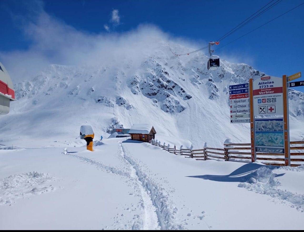
Swiss ski areas also saw some spectacular snowfalls at the end of last week, heaviest in the Valais and wider Western Swiss region, but extending into Central Switzerland and, by the weekend, across the country. Thursday saw resorts including Saas Fee (85/420 cm / 34/168”) and Zermatt (80/100 cm / 32/40”) cut off by the heavy snowfall. Power lines were down, the avalanche danger was at maximum, and not only were all ski slopes closed, but people were being advised to stay indoors for safety reasons. Things did start to ease fairly quickly from Friday as the sunshine returned. Saas Fee actually posted one of the biggest snowfall totals anywhere—165 cm (66”) by Saturday—and jumped to the deepest reported base in Europe by a metre. Trains started running regularly again to Zermatt by Saturday, although its slopes remained closed until Easter. There are a dozen Swiss centres still open, about half of them planning to close after this Sunday.
SWITZERLAND FORECAST
Swiss ski areas may see some decent snowfall above 2,000–2,500 m altitudes, with 10–20 cm (4–8”) accumulations forecast. Temperatures at lower elevations are much too warm for snowfall now, though. It’s looking like a drier end to the week, with more snowfall forecast on high slopes at the weekend.
PYRENEES REPORT
The ski season in the Pyrenees is more or less over, with the last of the big ski areas closing after the Easter weekend. After the largely dry first three-quarters of the season, the final centres open went out on a high, reporting up to 50 cm (20”) of snowfall up to Easter. There are ski areas still open in the wider region, though, with Europe’s most southerly resort, Spain’s Sierra Nevada (30/200 cm / 12/80”), intending to stay open into May. It also saw fresh snowfall at the end of last week and overnight lows below freezing on its higher slopes, but it’s down to about half its runs still open and reports freeze–thaw conditions.
PYRENEES FORECAST
Mostly sunny weather is expected for the rest of this week, with valley highs reaching +20°C, but overnight lows still getting below freezing on the highest peaks. A weak front should pass through at the weekend, but it looks sunny again next week too.
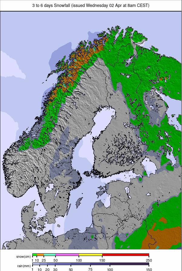
SCANDINAVIA REPORT
Scandinavian ski areas continue to post some of the best conditions in Europe as we reach the final few weeks of the season for most. There’s been quite a temperature range between southerly and northerly parts of the region, with +10°C reached in the south, but overnight lows of -20°C still reported at Riksgränsen (75/186 cm / 30/75”), which still has a month of its season left to run and is now posting the region’s deepest snow. Most have seen a mixture of sunshine and snow showers this week, the latter heavier in the north. Unlike other regions, about 80% of Scandinavian areas were still open up to the Easter weekend, although a chunk of them did close on Monday. Still, most of the leading centres remain open. The region’s largest area, Sweden’s Åre (25/42 cm / 10/17"), continues to offer the largest amount of skiable terrain.
SCANDINAVIA FORECAST
Some very cold weather and snowfall continue up in the Arctic Circle, where temperatures will range from -2°C to -20°C, with snowfall of 2–10 cm (1–4") daily expected. It’s drier and warmer in more southerly parts of Scandinavia, although still cooler than all but the high Alps.