60cm Snowfall Blankets Europe, Creating Prime Powder Conditions
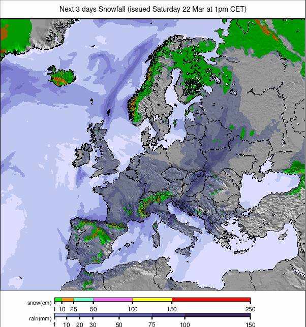
Updated March 19, 2025: Europe’s ski season is thriving, with up to 60cm (2ft) of fresh snow blankets the Alps, powdery peaks and sunny skies. More snow is incoming — click for details!
- Spring Arrives: Lower Slopes Thaw as High Resorts Stay Snowy
- French Alps Avalanche Risk Raised After Deep Snowfall
- Scandinavia Holds Perfect Winter Conditions with Fresh Snow
- Scottish Ski Season Wavers as One Resort Closes, Another Reopens
EUROPE OVERVIEW
The snowfall that began in southwestern Europe last week has continued spreading across most of the continent, with some areas reporting snow totals of up to 60cm (2ft) by Monday morning. Since then, skies have cleared across the Alps, creating excellent powder conditions on higher slopes. As we approach astronomical spring, alongside meteorological spring already in effect, the shifting seasons are becoming evident. Lower-lying slopes are receiving little of the recent snowfall, experiencing more sleet or rain instead. Some ski areas at lower altitudes (below 2,000m) anticipate their final week of the 24-25 winter season. However, many resorts will remain open into April, with some extending operations into May and beyond. Elsewhere in Europe, the Pyrenees are experiencing their best month of the season, boasting the highest terrain availability following additional snowfall. Scandinavian ski resorts are maintaining excellent conditions thanks to low temperatures, while Eastern Europe enjoys abundant sunshine. In Scotland, one ski center has concluded its 24-25 season, but another has reopened some terrain.
AUSTRIA REPORT
Following a snowy weekend, Austria is now basking in sunshine, with afternoon temperatures reaching +5°C at 2,000m and up to +15°C in valleys. Overnight temperatures continue to drop below freezing at all altitudes, leading to classic spring freeze-thaw conditions. Some Austrian resorts are entering their final weeks of operation, with several closing lower-lying terrain rather than struggling to maintain them. The expansive SkiWelt (50/80cm / 20/32") remains approximately 75% open, still offering over 200km (125 miles) of runs.
AUSTRIA FORECAST
Sunny conditions will persist through Thursday before a more unsettled pattern begins. Temperatures will drop slightly over the weekend, with cloud cover increasing and snowfall expected to return by Sunday.
FRANCE REPORT
Last week’s snowfall in the southern French Alps extended over five days, concluding on Sunday. Some resorts, such as Serre Chevalier (35/160cm / 14/64”), reported a total of 60cm (24”). Val d'Isère (100/155cm / 40/62") and several other high-altitude areas received around 50cm (20") of fresh snow, with snowfall reaching valley floors. Powder conditions prevailed at the beginning of the week, although initial visibility was limited due to low clouds, which later cleared. Off-piste skiers were advised of an increased avalanche danger level of 3 out of 5 (‘considerable’).
FRANCE FORECAST
A few more days of sunshine are expected before cloud cover increases on Thursday or Friday. Light snow showers may return over the weekend, primarily on Sunday. Temperatures will drop slightly but will continue following a freeze-thaw cycle.
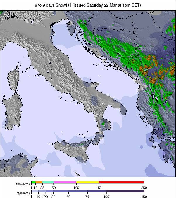
ITALY REPORT
Italian ski resorts experienced some of their best snowfalls of the season last weekend, with snowfall occurring across the country—an uncommon occurrence this season. Val Gardena (65/110cm / 26/44") in the Dolomites recorded one of the highest accumulations at 40cm (16”), while Arabba (25/70cm / 10/28") received 25cm (10”). Further west, Cervinia and other eastern resorts enjoyed three days of powder conditions. The fresh snowfall caused World Cup Downhill ski races in La Thuile to be reclassified as Super-Gs. Since the start of the week, conditions have been dry and sunny, providing ideal conditions for skiing.
ITALY FORECAST
Mostly sunny conditions will persist across Italian ski regions for the next 24-48 hours. However, cloud cover is expected to build as a new front approaches later this week, bringing a temperature drop and increasingly heavy snowfall over the weekend.
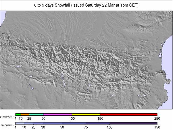
PYRENEES REPORT
The Pyrenees have experienced yet another excellent week of snowfall, marking three consecutive weeks of fresh snow after an extended period of mostly dry weather. This has created some of the best conditions of the winter, with powder snow reported throughout the region, even reaching as far south as Europe’s southernmost ski area in Sierra Nevada, Spain. Additionally, France’s Gavarnie/Gèdre (30/200cm / 12/80”) is the first resort in the region to post a two-metre (80”) base this season. The amount of open terrain has also hit a seasonal record, with Andorra’s Grandvalira (110/170cm / 44/68”)(including Pas de la Casa and Soldeu) offering over 200km (125 miles) of skiable slopes for the first time this season. Recently, the sun has made a return, bringing slightly milder temperatures, though more snow is predicted in the coming days.
PYRENEES FORECAST
There’s no real end to the unsettled conditions although there will be periods with clear, sunny skies. But we’ll continue to see snow showers adding 5-10cm most days to most areas. It looks like there’ll be heavier snowfall to start next week too but that’s too far off for certainty at this point.
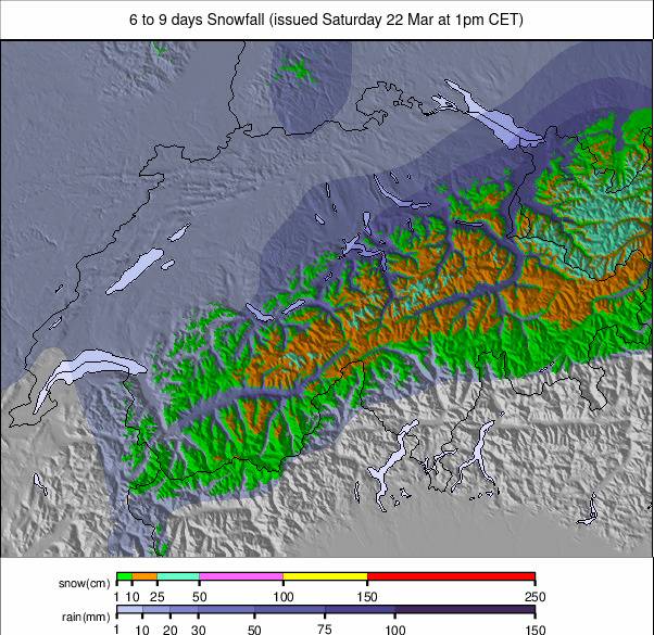
SWITZERLAND REPORT
Swiss ski resorts enjoyed a snowy end to last week, with Laax (5/120cm / 2/48") recording the highest accumulation—60cm (2ft) over 72 hours leading up to Sunday. Most Swiss resorts benefited, particularly at higher elevations, reporting powder conditions through the weekend and early this week. Andermatt (66/160cm / 26/64") and Saas-Fee (50/250cm / 20/100") each received 40cm (16”). While sunshine has returned to most of the country, the southeast (including Arosa and St. Moritz) is still experiencing some cloud cover and light snowfall. Conditions have cooled since the snow front passed, with freezing levels around 1,800m in the afternoons and nighttime lows dropping below -10°C on high slopes, with subzero temperatures extending to valleys.
SWITZERLAND FORECAST
Sunny conditions will continue for much of Switzerland over the next 24-48 hours before increasing cloud cover and a slight temperature drop ahead of the weekend. Light snowfall is expected initially, with the potential for heavier accumulations early next week, though forecasts remain uncertain at this stage.
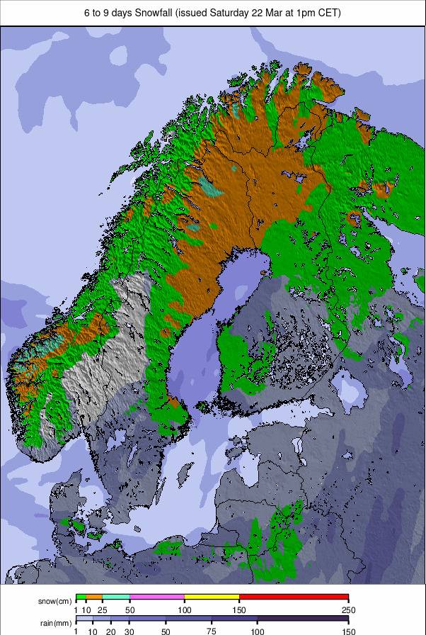
SCANDINAVIA REPORT
Scandinavian ski resorts continue to enjoy excellent conditions, with consistently low temperatures preserving recent snowfall. Norway’s Hemsedal (90/120cm / 36/48") and Sweden’s Åre (50/90cm / 20/36") both reported light snow showers at the beginning of the week, adding a fresh layer to well-established bases. Finland’s Levi (60/80cm / 24/32") has also maintained strong snow coverage, benefiting from cold overnight temperatures preventing significant melt.
SCANDINAVIA FORECAST
Cold conditions will persist through the week, with intermittent light snow showers expected across Norway and Sweden. Finland will see drier conditions but continued low temperatures, preserving snow quality.
EASTERN EUROPE REPORT
Ski resorts in Eastern Europe, including those in Slovakia, Poland, and Bulgaria, have benefited from stable weather this past week. Bulgaria’s Bansko (40/100cm / 16/40") reported good skiing conditions, though lower runs are starting to show signs of springtime melting. Slovakia’s Jasná (50/90cm / 20/36") remains in good shape, with morning conditions firming up before softening in the afternoon.
EASTERN EUROPE FORECAST
Sunshine and mild temperatures will persist in the coming days, leading to a gradual decline in snow conditions at lower elevations. Higher-altitude resorts will maintain better coverage, with potential for light snowfall early next week.
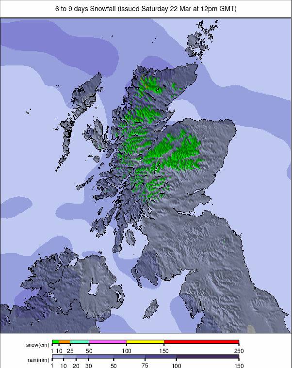
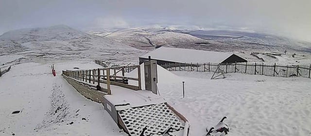
SCOTLAND REPORT
Scotland’s ski season remains inconsistent, with one ski area recently closing for the season while another has reopened limited terrain following fresh snowfall. Cairngorm Mountain (10/50cm / 4/20") saw light snow earlier this week, allowing for some improved skiing conditions. However, warmer temperatures are leading to rapidly changing conditions.
SCOTLAND FORECAST
A mix of sunshine and occasional light rain or snow showers is expected over the next few days. The outlook remains uncertain for continued operations, depending on further snowfall and temperature trends.