Snowstorm Hits Pyrenees as Spring Weather Arrives in Europe
Updated March 5, 2025: Spring sunshine dominates across Europe, but heavy snow is expected in the Pyrenees. Will the Alps catch up with more snow?
- Spring Sun Dominates Alps, But Pyrenees Brace for Major Snow Dump
- Austria & France Enjoy Powder Weekend Before Warmer, Springlike Conditions Set In
- Pyrenees Poised for Biggest Snowfall of the Season—Over 1m Expected
- Scandinavia Sees Mixed Bag—Sun, Snow, and Thawing Bases
- Scottish Resorts Hold On as Machine-Made Snow Keeps Slopes Open
EUROPE OVERVIEW
After the snowfalls in the Alps in the middle of last week we’ve had a return to predominantly sunny conditions across most of western Europe since the weekend, with initially low, largely subzero temperatures at the weekend becoming something much more spring-like over the past few days. And springtime it is, at least by the meteorological measure of the seasons, so the start of freeze-thaw conditions (well, they’d already started on lower slopes last month) should not be a surprise. The past few springtimes have seen some of the heaviest snowfalls of the ski seasons on the Alps. It remains to be seen if things change and that's how things end up this spring, for now, the deepest snow lying at around 3 metres is not very inspiring compared to the 5-6 metre depths we saw at the start of March only a few years ago. The first 10 days or so of March look like they'll be mostly sunny and warm in valleys so the early signs aren’t that promising although there’s heavy snow forecast for the Pyrenees at least. Whatever happens over the coming month or so though, most of the continent’s destination ski areas have 90% or more of their slopes open and look well set to see it through to the ends of their seasons in April and May.
AUSTRIA REPORT
Austrian ski areas saw some snowfall in the middle of last week which continued through to the weekend, since when we’ve had predominantly sunny conditions across the country. The snowfalls were in the 10-45cm (4-18”) bracket with those along the southern borders of Austria posting some of the biggest falls this time, topped by Nassfeld (10/120cm / 4/48”) which reported 45cm (18”), one of the biggest accumulations in the Alps from the past seven days. Since Saturday it's been mostly sunshine everywhere with temperatures starting cold, but progressively climbing higher, with highs around +11C reached in valleys below 1,000m altitudes, so it is very springlike there. Most of the country's larger resorts remain fully open though, albeit with lower slopes now white ribbons on green valley sides.
AUSTRIA FORECAST
Mostly sunny weather is set to continue in Austria through the remainder of this week and into next. In the country's lower valleys, towards 600m altitudes, we'll see the first +15Cs of the year so that's going to impact the lower snowpack.
FRANCE REPORT
The forecast snow that was already starting to fall as we published last week’s report turned out a little more substantial than expected with streets turning white down to resort level in the Portes du Soliel and many other areas. Tignes (135/205cm / 54/82”) posted a 30cm (12”) accumulation and Chamonix (20/300cm / 8/120”) 20cm (8”). The skies cleared at the weekend but it stayed cold, with temperatures remaining below freezing down to low levels, all the ingredients of great powder conditions. It has stayed sunny since too, with temperatures climbing again though.
FRANCE FORECAST
Sunny weather continues through the remainder of this week and into the weekend with just a sign of the weather changing and temperatures dropping in the latter half of the weekend. Until then it'll be freeze-thaw with temperatures fluctuating between -12C overnight up to 3,000m to +12C in the afternoons down at 1000m altitudes.
ITALY REPORT
Italy has also enjoyed a predominantly sunny week after the snowfall in the middle of last week. Andalo (70/110cm / 28/44”) in Trentino posted the most snowfall in Europe for the final part of last week, with 47cm (19") in 72 hours, leading to powder conditions for the weekend. Other ski areas in Trentino also reported some weekend snowfall when most of the rest of the country (and the Alps) were sunny and dry. Valley temperatures in Italy too have been getting up to double figures in the afternoons but so far the hard-packed bases, though not more than half a metre thick in some cases, are holding up to the spring warmth and most Italian areas remain fully open for the start of March.
ITALY FORECAST
Looking largely sunny and remaining dry on Italian slopes for the remainder of this week and into the weekend too. Temperatures remain in the -10 to +10C range, the snowline moving between 1000m and 2500m altitudes so standard springtime freeze-thaw conditions with the snow in its best shape in the mid-morning and up at altitude.
SWITZERLAND REPORT
Most ski areas in Switzerland have also seen almost constant sunny weather following the snowfall in the middle of last week. There was something of a powder weekend here as well, as temperatures stayed low following accumulations of up to 30cm (12") on Wednesday/Thursday last week, with the west of the country seeing marginally bigger accumulations. Leysin (10/150cm / 4/60"), Champery (40/140cm / 16/56”) and Glacier 3000 (10/240cm / 4/96”) were among the bigger beneficiaries. There was some light snowfall through the weekend but they could mostly be measured in millimetres. Temperatures have started climbing again since the start of the week.
SWITZERLAND FORECAST
There's little change to the sunshine of the past week in the forecast for the remainder of this week and through the weekend. It remains wall-to-wall sunshine across Switzerland, perhaps just a chance of more clouds bubbling up into the weekend. Temperatures will continue to reach double figures in the afternoons in valleys, with lows up high getting just below freezing overnight.
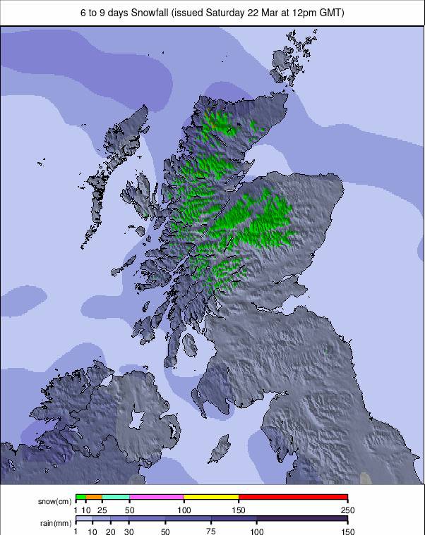
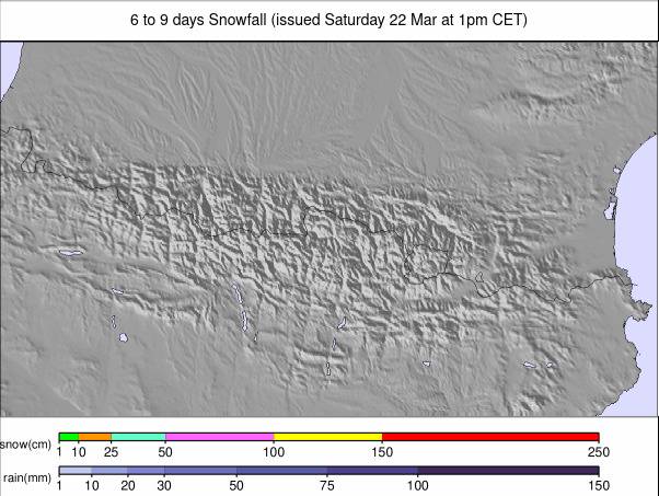
PYRENEES REPORT
Whilst the Alps have had a largely dry week, especially since the weekend, the Pyrenees have continued to see snow showers over much of the past seven days, as more unsettled weather swirls around more southerly parts of the continent. There haven't been any spectacular accumulations, and most of the snow is falling on higher terrain, but most areas have seen 2-20cm (1-4 inches) daily, keeping slope cover fresh. The freezing point has been moving between 1,000 and 2,000m altitudes. The best conditions continue to be in France, where several areas are 100% open, including Piau Engaly (110/180cm / 44/72”) which has the region’s deepest snowpack. Andorra’s Grandvalira (75/125cm / 30/50”) has 90% of its slopes open, the most of the season and the most in the region.
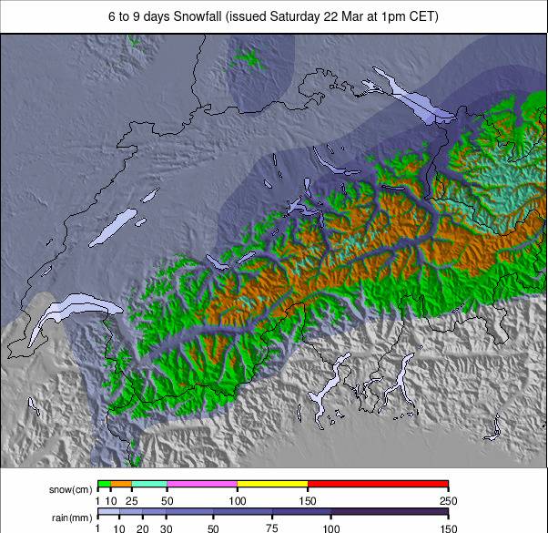
PYRENEES FORECAST
It currently looks like the Pyrenees are set to see significant snowfall through the latter half of this week, potentially the biggest of the season so far, with 20-40cm (8-16") accumulations expected daily right through the weekend, meaning 1m (40") plus totals by early next week if it arrives as models currently predict. Temperatures will be a few degrees on either side of freezing.
SCANDINAVIA REPORT
Mixed conditions in Scandinavia with plenty of sunshine but also snow showers, heaviest once again on the region’s west coast in Norway. Temperatures have been fluctuating a good deal too from lows around -15C to highs closer to +8C which has meant, at the warmer end, resulting in some rain. The deepest snow depth reported in the region, at Norway’s Myrkdalen (80/180cm / 32/72”), has actually dropped 10cm (4”) over the last week. Overall though, even if it’s not one of the best seasons for snow cover, most Scandi centres continue to report 70-90% of their slopes open.
SCANDINAVIA FORECAST
A mix of sunshine, cloud, dry weather and wet as temperatures fluctuate between -8 and +8C. Those positive numbers mean precipitation will be rain and sleet rather than snow for some ski areas midweek, although it should be snowfall still for most. Only light showers either way.
EASTERN EUROPE REPORT
Many parts of Eastern Europe saw snowy weather at the weekend with 10-20cm (4-8”) accumulations reported from as far south as Bansko in Bulgaria (40/170cm, 16/68”) where it bolstered lower base depths. However warmer temperatures in the north have hit base depths at the largest centre, Slovakia's Jasna (30/60cm / 12/24") which have lost nearly half their depth at resort level. It’s still close to full operations though. Since the weekend the sunny conditions further west have continued into the region, bringing dry weather and progressively rising temperatures, here too reaching +10C in valleys and getting above freezing.
EASTERN EUROPE FORECAST
Full on springtime across the region with overnight lows on high slopes only just getting down towards freezing point, but daytime highs in valleys getting up top +10 to +15C. Full on sunshine across the region so inevitable springtime thawing is on the way.
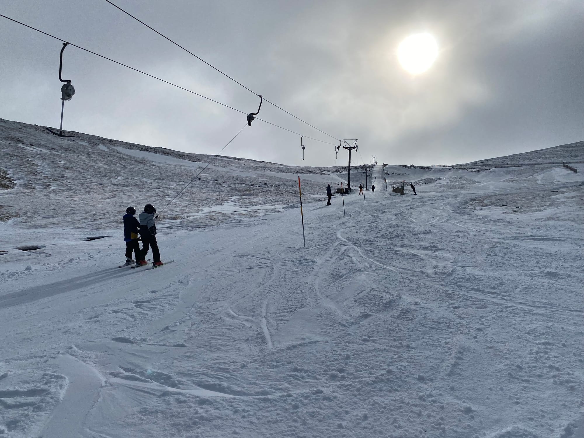
SCOTLAND REPORT
Scottish centres are hoping to rebuild natural bases after a thaw over the weekend before last wiped out much of what snow there was. Initially, the accompanying strong winds and heavy rain also impacted even the small areas of all-weather snow-machine-made-snow that four of the five centres operate, with The Lecht forced to close for several days whilst they made fresh. But still, recent low temperatures and natural snowfall have left things looking much better. Just not quite good enough for natural terrain to reopen yet, with centres saying more snow is needed and the weekend weather largely dry and settled. Overnight lows have continued to be subzero down to valley bottoms, but daytime highs continue to climb towards double figures above freezing, so what natural snow there is, is currently quite high up. Glencoe, Glenshee, Cairngorm and The Lecht all have some terrain open thanks to the machine-made snow. Cairngorm though has also managed to open some natural terrain from its newly re-accessible funicular top station, serviced by the Ptarmigan tow. Nevis Range has not managed to open this year.
SCOTLAND FORECAST
Unfortunately, temperatures look set to remain rather warm for the week ahead with valley highs getting above 10C most days in most areas. So showers will most likely be rain to high levels, with some hill snow possible overnight as temperatures drop.