
Ski Hire by Intersport
Click here for discount

Flachau-Reitdorf Weather (Next 3 days): The snow forecast for Flachau-Reitdorf is: Mild with moderate rain (total 19.0mm) on Sat morning, Becoming colder with a light covering of snow, mostly falling on Mon night. Freeze-thaw conditions (max 4°C on Sat afternoon, min -4°C on Sat night). Wind will be generally light.
Flachau-Reitdorf Weather (Days 4-6): Moderate rain (total 18.0mm) heaviest on Tue afternoon, then becoming colder with a dusting of snow on Tue night. Freeze-thaw conditions (max 5°C on Thu afternoon, min -2°C on Wed night). Wind will be generally light.
| Resort | Snow Depth | Temp. (°C) | Wind (km/h) | Weather | ||
|---|---|---|---|---|---|---|
| Top Lift: | 0.0 m | -7 | ||||
| Middle Lift: | -2 | |||||
| Bottom Lift: | 0.0 m | 2 |
Latest snow reports near Flachau-Reitdorf:
Light rain showers reported from Obertauern (automatic) at 1742 metres elevation one km N of Obertauern but it is forecast cold enough for snow at the ski area from Obertauern
Intermittent light rain reported from Bischofshofen at 550 metres elevation 8 kms S of Werfenweng but it is forecast cold enough for snow at the ski area from Werfenweng
Intermittent light rain reported from Bischofshofen at 550 metres elevation 6 kms NW of Wagrain but it is forecast cold enough for snow at the ski area from Wagrain

Saturday 20 | Sunday 21 | Monday 22 | Tuesday 23 | Wednesday 24 | Thursday 25 | Friday 26 | |||||||||||||||
AM | PM | night | AM | PM | night | AM | PM | night | AM | PM | night | AM | PM | night | AM | PM | night | AM | PM | night | |
light snow | light rain | light snow | light rain | light rain | light snow | cloudy | light rain | light snow | light snow | light rain | light snow | light snow | light rain | light snow | light rain | light rain | rain shwrs | cloudy | light rain | rain shwrs | |
km/h | |||||||||||||||||||||
Snow map |  |  |  |  |  |  |  | ||||||||||||||
1.0 | — | 2.0 | — | — | 1.0 | — | — | 2.0 | — | — | 2.0 | 1.0 | — | 1.0 | — | — | — | — | — | — | |
3 | 5 | — | 1.0 | 4 | — | — | 3 | 3 | 1.0 | 4 | — | 2.0 | 4 | — | 1.0 | 3 | 3 | — | 2.0 | 1.0 | |
max°C | 3 | 4 | 0 | 3 | 4 | 1 | 3 | 4 | 3 | 3 | 4 | 1 | 2 | 4 | 1 | 3 | 5 | 3 | 6 | 8 | 4 |
min°C | 2 | 3 | -4 | 0 | 3 | -2 | 0 | 4 | 0 | 1 | 3 | -1 | 1 | 3 | -2 | 1 | 5 | -2 | 3 | 8 | 2 |
1 | 0 | -4 | 0 | 0 | -2 | 0 | 3 | 0 | 1 | 0 | -3 | -1 | 1 | -2 | 1 | 4 | -5 | 1 | 8 | 0 | |
91 | 80 | 98 | 81 | 89 | 93 | 78 | 93 | 96 | 90 | 94 | 98 | 91 | 93 | 99 | 86 | 92 | 96 | 81 | 82 | 93 | |
1150 | 1250 | 650 | 1200 | 1200 | 700 | 1150 | 1350 | 850 | 1250 | 1250 | 800 | 1100 | 1200 | 700 | 1200 | 1500 | 800 | 1700 | 1950 | 1550 | |
6:07 | — | — | 6:05 | — | — | 6:03 | — | — | 6:01 | — | — | 6:01 | — | — | 5:58 | — | — | 5:56 | — | — | |
— | — | 8:02 | — | — | 8:04 | — | — | 8:05 | — | — | 8:07 | — | — | 8:07 | — | — | 8:09 | — | — | 8:10 | |
Mild with moderate rain (total 19.0mm) on Sat morning, Becoming colder with a light covering of snow, mostly falling on Mon night. Freeze-thaw conditions (max 4°C on Sat afternoon, min -4°C on Sat night). Wind will be generally light.
Moderate rain (total 18.0mm) heaviest on Tue afternoon, then becoming colder with a dusting of snow on Tue night. Freeze-thaw conditions (max 5°C on Thu afternoon, min -2°C on Wed night). Wind will be generally light.
Latest snow reports near Flachau-Reitdorf:
Light rain showers reported from Obertauern (automatic) at 1742 metres elevation one km N of Obertauern but it is forecast cold enough for snow at the ski area from Obertauern
Intermittent light rain reported from Bischofshofen at 550 metres elevation 8 kms S of Werfenweng but it is forecast cold enough for snow at the ski area from Werfenweng
Intermittent light rain reported from Bischofshofen at 550 metres elevation 6 kms NW of Wagrain but it is forecast cold enough for snow at the ski area from Wagrain
| Top snow depth: | 0 cm |
|---|---|
| Bottom snow depth: | 0 cm |
| Fresh snowfall depth: | 12 cm |
| Last snowfall: | 19 Apr 2024 |
| Snow Alerts | Create Alert |
0.0 | Bluebird Powder days Fresh snow, mostly sunny, light wind. |
|---|---|
0.1 | Powder days Fresh snow, limited sun, any wind. |
0.0 | Bluebird days Average snow, mostly sunny, light wind. |
The above table gives the weather forecast for Flachau-Reitdorf at the specific elevation of 762 m. Our sophisticated weather models allow us to provide snow forecasts for the top, middle and bottom ski stations of Flachau-Reitdorf. To access the weather forecasts for the other elevations, use the tab navigation above the table. For a wider view of the weather, check out the Weather Map of Austria.
Click here to read further information on freezing levels and how we forecast our temperatures.
Overall 4.6 Based on 6 votes and 9 reviews
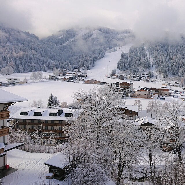
We visited Flachau-Reitdorf, (which is one of the major centres of the "Ski Amade" region in Austria) from 31st December to 7th January 2012 and had a superb time. The resort benefits from being a short 50 minutes drive from Salzburg airport, so by catching an early flight on the Saturday, we were skiing by noon and at the end of the holiday we were still on the slopes at 13.00, still with plenty of time to catch the 16.25 flight home! 8 days skiing for a week's trip - excellent value!! Very little snow had fallen across the Alps until mid December 2011, so I was worried we would be hill walking rather than enjoying skiing, but the resort website gave a categoric "100% snow guarantee", so I felt more optimistic, especially whenever the temperature dropped, they turned on their extensive network of snow cannons. So luckily when we arrived there was loads of snow (170cm at the top and 70cm in the resort). The pistes were immaculately groomed, with one or two black run pistes deliberately left untouched so that you could enjoy the powder snow conditions. The ski pass was pricey, 256 euros for 8 days skiing, but the ticket does allow you to enjoy up to 860 km of pistes and 270 lifts in the “ski Amade” region that includes the ski resorts of Wagrain, Filzmoos, Zauchensee, Flachauwinkl, Kleinarl, Schladming and 18 other ski centres! We stayed in a self catering apartment in Reitdorf, (about 2 km from the slopes), with a lovely family, Theresa and Patrick Pilcher (haus.rupert.pichler@sbg.at ) We used a hire car to get to Flachau-Reitdorf from the airport and also to access the other nearby ski centres. Despite all the snow falling whilst we were there, the Austrians are brilliant at clearing the roads throughout the day and night, so there is no problem driving to the ski slopes which all have large, well organised (free) parking. The only down-side of Flachau-Reitdorf appeared to be the free ski-bus system that appeared to be a little slow and inconsistent, especially during the middle of the day, so overall I would strongly recommend hiring a car from the airport. Flachau-Reitdorf is not a high altitude resort, so there is always concern about enough snow, but as mentioned above, the use of snow cannons in the resort is verging on obsessive. For example, despite 40cm of snow falling one day when we were there, they still turned the snow cannons on! The pistes are mostly red and blue runs with a few black runs, so the resort generally suits intermediate but also ski beginners. If you are a true "black run junky" there are areas of off-piste to keep you entertained, but there is no hiding from the fact that the resort has a shortage of black runs. Overall, we had a superb family holiday and whole heartedly recommend Flachau-Reitdorf to you. Guy Pocock
Guy Pocock from United Kingdom writes:
We visited Flachau-Reitdorf, (which is one of the major centres of the "Ski Amade" region in Austria) from 31st December to 7th January 2012 and had a superb time. The resort benefits from being a short 50 minutes drive from Salzburg airport, so by catching an early flight on the Saturday, we were skiing by noon and at the end of the holiday we were still on the slopes at 13.00, still with plenty of time to catch the 16.25 flight home! 8 days skiing for a week's trip - excellent value!!
Very little snow had fallen across the Alps until mid December 2011, so I was worried we would be hill walking rather than enjoying skiing, but the resort website gave a categoric "100% snow guarantee", so I felt more optimistic, especially whenever the temperature dropped, they turned on their extensive network of snow cannons. So luckily when we arrived there was loads of snow (170cm at the top and 70cm in the resort). The pistes were immaculately groomed, with one or two black run pistes deliberately left untouched so that you could enjoy the powder snow conditions.
The ski pass was pricey, 256 euros for 8 days skiing, but the ticket does allow you to enjoy up to 860 km of pistes and 270 lifts in the “ski Amade” region that includes the ski resorts of Wagrain, Filzmoos, Zauchensee, Flachauwinkl, Kleinarl, Schladming and 18 other ski centres!
We stayed in a self catering apartment in Reitdorf, (about 2 km from the slopes), with a lovely family, Theresa and Patrick Pilcher (haus.rupert.pichler@sbg.at ) We used a hire car to get to Flachau-Reitdorf from the airport and also to access the other nearby ski centres. Despite all the snow falling whilst we were there, the Austrians are brilliant at clearing the roads throughout the day and night, so there is no problem driving to the ski slopes which all have large, well organised (free) parking. The only down-side of Flachau-Reitdorf appeared to be the free ski-bus system that appeared to be a little slow and inconsistent, especially during the middle of the day, so overall I would strongly recommend hiring a car from the airport.
Flachau-Reitdorf is not a high altitude resort, so there is always concern about enough snow, but as mentioned above, the use of snow cannons in the resort is verging on obsessive. For example, despite 40cm of snow falling one day when we were there, they still turned the snow cannons on! The pistes are mostly red and blue runs with a few black runs, so the resort generally suits intermediate but also ski beginners. If you are a true "black run junky" there are areas of off-piste to keep you entertained, but there is no hiding from the fact that the resort has a shortage of black runs.
Overall, we had a superb family holiday and whole heartedly recommend Flachau-Reitdorf to you.
Guy Pocock
The Flachau-Reitdorf skiing weather widget is available to embed on external websites free of charge. It provides a daily summary of our Flachau-Reitdorf snow forecast and current weather conditions. Simply go to the feed configuration page and follow the 3 simple steps to grab the custom html code snippet and paste it into your own site. You can choose the snow forecast elevation (summit, mid-mountain or bottom lift) and metric/imperial units for the snow forecast feed to suit your own website…. Click here to get the code.
View detailed snow forecast for Flachau-Reitdorf at:
snow-forecast.com


 Nearest