
Ski Lessons by SkiBro
BOOK NOW
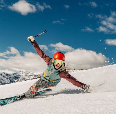
Ski lessons in Alpe d'Huez
Book now


Alpe d'Huez Weather (Next 3 days): The snow forecast for Alpe d'Huez is: Moderate rain (total 13.0mm), heaviest on Fri afternoon. Freeze-thaw conditions (max 11°C on Sat afternoon, min -2°C on Thu morning). Wind will be generally light.
Alpe d'Huez Weather (Days 4-6): Moderate rain (total 17.0mm), heaviest on Sun afternoon. Very mild (max 14°C on Mon afternoon, min 5°C on Sun night). Wind will be generally light.
| Resort | Snow Depth | Temp. (°C) | Wind (km/h) | Weather | ||
|---|---|---|---|---|---|---|
| Top Lift: | 0.0 m | -12 | ||||
| Middle Lift: | -6 | |||||
| Bottom Lift: | 0.0 m | -2 |
Latest snow reports near Alpe d'Huez:
Snowing in Val Thorens. from Val Thorens
Great snow conditions throughout area. Snowing lightly, refreshing pistes. from Val Thorens

Thursday 25 | Friday 26 | Saturday 27 | Sunday 28 | Monday 29 | Tuesday 30 | Wednesday 1 | |||||||||||||||
AM | PM | night | AM | PM | night | AM | PM | night | AM | PM | night | AM | PM | night | AM | PM | night | AM | PM | night | |
clear | clear | some clouds | light rain | mod. rain | light rain | cloudy | cloudy | light rain | light rain | mod. rain | some clouds | cloudy | light rain | light rain | cloudy | light rain | light rain | light rain | light rain | light rain | |
km/h | |||||||||||||||||||||
Snow map |  |  |  |  |  |  |  | ||||||||||||||
— | — | — | — | — | — | — | — | — | — | — | — | — | — | — | — | — | — | — | — | — | |
— | — | — | 1.0 | 6 | 1.0 | — | — | 5 | 5 | 6 | — | — | 1.0 | 1.0 | — | 2.0 | 2.0 | 2.0 | 3 | 4 | |
max°C | 4 | 8 | 4 | 6 | 7 | 5 | 8 | 11 | 8 | 8 | 10 | 8 | 12 | 14 | 10 | 13 | 12 | 9 | 11 | 11 | 9 |
min°C | -2 | 7 | 2 | 4 | 5 | 3 | 4 | 11 | 5 | 6 | 8 | 5 | 8 | 13 | 6 | 8 | 11 | 6 | 8 | 10 | 7 |
-2 | 6 | 2 | 3 | 4 | 1 | 2 | 10 | 3 | 4 | 7 | 3 | 7 | 13 | 4 | 7 | 11 | 5 | 8 | 10 | 6 | |
45 | 44 | 73 | 81 | 97 | 83 | 64 | 60 | 86 | 90 | 74 | 71 | 70 | 71 | 83 | 70 | 73 | 84 | 77 | 90 | 85 | |
1550 | 2000 | 1650 | 1900 | 1900 | 1850 | 2250 | 2500 | 2300 | 2500 | 2700 | 2450 | 2750 | 2950 | 3050 | 2850 | 2750 | 2650 | 2650 | 2700 | 2500 | |
6:33 | — | — | 6:31 | — | — | 6:30 | — | — | 6:28 | — | — | 6:26 | — | — | 6:24 | — | — | 6:24 | — | — | |
— | — | 8:34 | — | — | 8:35 | — | — | 8:37 | — | — | 8:37 | — | — | 8:38 | — | — | 8:39 | — | — | 8:42 | |
Moderate rain (total 13.0mm), heaviest on Fri afternoon. Freeze-thaw conditions (max 11°C on Sat afternoon, min -2°C on Thu morning). Wind will be generally light.
Moderate rain (total 17.0mm), heaviest on Sun afternoon. Very mild (max 14°C on Mon afternoon, min 5°C on Sun night). Wind will be generally light.
Latest snow reports near Alpe d'Huez:
Snowing in Val Thorens. from Val Thorens
Great snow conditions throughout area. Snowing lightly, refreshing pistes. from Val Thorens
| Top snow depth: | 0 cm |
|---|---|
| Bottom snow depth: | 0 cm |
| Fresh snowfall depth: | 10 cm |
| Last snowfall: | 23 Apr 2024 |
| Snow Alerts | Create Alert |
0.0 | Bluebird Powder days Fresh snow, mostly sunny, light wind. |
|---|---|
0.1 | Powder days Fresh snow, limited sun, any wind. |
0.0 | Bluebird days Average snow, mostly sunny, light wind. |
The above table gives the weather forecast for Alpe d'Huez at the specific elevation of 1100 m. Our sophisticated weather models allow us to provide snow forecasts for the top, middle and bottom ski stations of Alpe d'Huez. To access the weather forecasts for the other elevations, use the tab navigation above the table. For a wider view of the weather, check out the Weather Map of France.
Click here to read further information on freezing levels and how we forecast our temperatures.
Overall 4.0 Based on 70 votes and 109 reviews
В феврале вернулись из недельного отпуска в Alpe D'Huez. Ездили компанией, у всех были разные интересы и запросы, но доволен остался каждый, это было здорово для всех. Во-первых, мы были очень удивлены, что трассы были не слишком заняты, и мы не стояли в очереди на подъемники. Снег был хорошим - чего еще можно желать! Еда очень вкусная и разнообразная, шведский стол. Сервис отличный, персонал очень отзывчивый. Вообще, в целом, впечатления от отдыха остались только хорошие, потому что в КлабМед они предусмотрели буквально каждую мелочь для любого гостя. Высший балл.
Manul from Russia writes:
В феврале вернулись из недельного отпуска в Alpe D'Huez. Ездили компанией, у всех были разные интересы и запросы, но доволен остался каждый, это было здорово для всех. Во-первых, мы были очень удивлены, что трассы были не слишком заняты, и мы не стояли в очереди на подъемники. Снег был хорошим - чего еще можно желать!
Еда очень вкусная и разнообразная, шведский стол. Сервис отличный, персонал очень отзывчивый. Вообще, в целом, впечатления от отдыха остались только хорошие, потому что в КлабМед они предусмотрели буквально каждую мелочь для любого гостя. Высший балл.
The Alpe d'Huez skiing weather widget is available to embed on external websites free of charge. It provides a daily summary of our Alpe d'Huez snow forecast and current weather conditions. Simply go to the feed configuration page and follow the 3 simple steps to grab the custom html code snippet and paste it into your own site. You can choose the snow forecast elevation (summit, mid-mountain or bottom lift) and metric/imperial units for the snow forecast feed to suit your own website…. Click here to get the code.
View detailed snow forecast for Alpe d'Huez at:
snow-forecast.com


 Nearest