 Ski Turkey
Turkey has the potential to be one of the world’s leading ski nations and its rulers know that, like Russia, China and Iran they are developing new ski areas in the more remote and politically sensitive areas – in Turkey’s case the East of the country in particular – with the aim of driving economic growth and employment in the region.
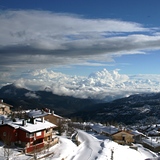
Because although it is best known to British tourists for its sunshine and beaches, Turkey is in fact a largely mountainous country, with some very high peaks in the East. So the country's 20 or so ski areas offer a very diverse mixture – some are close to the sea so you can combine a beach and snow holiday, some are in areas famous from antiquity with 6000 year old archaeological remains to explore in your après ski hours; others are highly fashionable.
Turkey’s original resort, Uludağ, remains its most fashionable and there are plans to upgrade its fragmented lift system.
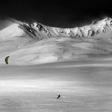
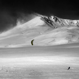
However the big success story in Turkish skiing of the past decade has been Mt Palandöken to the East above the ancient city of Erzurum. This installed modern chairlifts and a gondola around 2000 and looked set to make it big in the Western European market thanks to low prices and a big vertical with runs up to 17km long. But then Gulf War 2 began and the Western Corporations pulled out. However Mt Palandöken is now enjoying something of a peace dividend and hosted the University Winter Games – a prestigious global winter sports contest, in 2011.
-
8:52 am 17 Mar 2012
-
8:54 am 9 Feb 2010
-
-
8:52 am 17 Jan 2013
Turkey: latest snow conditions round-up
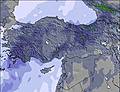
Summary of forecast snowfall and ski conditions for resorts in Turkey. Fresh snow is forecast at 17 resorts. Powder is reported at 0 resorts and 0 are reporting good piste conditions.
All resorts

Ski resorts of Turkey, alphabetically


|
|||||||||||||||||||||||||||||
|---|---|---|---|---|---|---|---|---|---|---|---|---|---|---|---|---|---|---|---|---|---|---|---|---|---|---|---|---|---|
| Resort |

|
snow depth top and bottom |
 on-piste |
 off-piste |
 Last Snow |
Next 9 Days 0–3 | 3–6 | 6–9 snow (cm) |
 Next 5 days weather forecast.
Freezing level (m) |
||||||||||||||||||||||
| Sun | Mon | Tue | Wed | Thu | |||||||||||||||||||||||||
|
(3060 m — 5163 m) snow report 2 days ago |
|
|
|||||||||||||||||||||||||||
|
(177 m — 1676 m) |
|
|
|||||||||||||||||||||||||||
|
(1993 m — 2524 m) snow report 2 days ago |
|
|
|||||||||||||||||||||||||||
|
(1400 m — 1699 m) |
|
|
|||||||||||||||||||||||||||
|
(1527 m — 2156 m) snow report 29 days ago |
|
|
|||||||||||||||||||||||||||
|
(1735 m — 2150 m) snow report 14 days ago |
|
|
|||||||||||||||||||||||||||
|
(1809 m — 2418 m) snow report 14 days ago |
|
|
|||||||||||||||||||||||||||
|
(1825 m — 1980 m) |
|
|
|||||||||||||||||||||||||||
|
(2001 m — 3001 m) snow report 13 days ago |
|
|
|||||||||||||||||||||||||||
|
(1740 m — 2970 m) snow report 5 days ago |
|
|
|||||||||||||||||||||||||||
|
(1899 m — 2499 m) snow report 14 days ago |
|
|
|||||||||||||||||||||||||||
|
(1859 m — 2225 m) snow report 6 days ago |
|
|
|||||||||||||||||||||||||||
|
(1300 m — 1699 m) snow report 6 days ago |
|
|
|||||||||||||||||||||||||||
|
(1600 m — 2034 m) snow report 5 days ago |
|
|
|||||||||||||||||||||||||||
|
(2100 m — 3100 m) snow report 2 days ago |
|
|
|||||||||||||||||||||||||||
|
(1050 m — 3340 m) snow report 2 days ago |
|
|
|||||||||||||||||||||||||||
|
(1999 m — 2399 m) |
|
|
|||||||||||||||||||||||||||
|
(2098 m — 2632 m) snow report 2 days ago |
|
|
|||||||||||||||||||||||||||
|
(1399 m — 2799 m) snow report 2 days ago |
|
|
|||||||||||||||||||||||||||
|
(1199 m — 2699 m) snow report 2 days ago |
|
|
|||||||||||||||||||||||||||
|
(1767 m — 2322 m) snow report 15 days ago |
|
|
|||||||||||||||||||||||||||
|
(1130 m — 2300 m) |
|
|
|||||||||||||||||||||||||||
|
(1740 m — 2335 m) snow report 5 days ago |
|
|
|||||||||||||||||||||||||||
|
(2051 m — 2251 m) snow report 3 days ago |
|
|
|||||||||||||||||||||||||||

 Nearest